
List members , this is astonishing news about Antarctica . A must read :-
UPDATED 28 AUGUST, 2021 - 02:00 WILLIAM JAMES VEALL
Astonishing Human Heads: Do Satellite Photographs Now Prove Existence of Humans on Antarctica…6000 Years Ago? – Part I
Accurate geographical and cartographical information concerning the continent of Antarctica has only really been uncovered since AD 1822. However, in direct contradiction, ancient maps reveal Antarctica completely free of glaciation thousands of years beforehand.
According to experts in ancient cartography and oceanography, only a very advanced maritime culture exploring Antarctica after the end of the last Ice Age, 11000 years ago, could possibly have created such maps. So, who was this suddenly, incredibly advanced civilization?
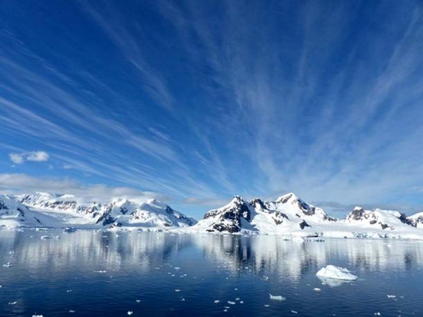
The beautiful but formidable landscape of Antarctica. ( Public Domain )
The failure to find an acceptable answer to this cartographic mystery led to speculation that ancient maps were produced by highly advanced aliens, because to produce maps of huge continental land masses, they could only be plotted accurately from an aerial perspective using surveying equipment especially designed for the purpose!
So, aliens excluded, which highly technically advanced cartographers could traverse our planet many thousands of years before the likes of Columbus, et al? Where did they come from and how did they come to possess the expertise and navigational ability to sail vast oceans and, most importantly, to record their findings on maps alleged to have been the sources of information passed on to ‘modern’ explorers like Columbus, Cook, Magellan or Vasco da Gama, for example.
Surprising Satellite Photography Reveals Antarctica’s Distant Past
To quote an example, there is the 16th Century ‘Buache’ map which he (Buache) claims to have been made by a very ancient civilization which accurately mapped the continent of Antarctica completely free of its one-mile deep ice cap. However, with no concrete proof to substantiate his claims, experts suspect Buache's map was probably the product of a vivid imagination. But was it? We shall see later.
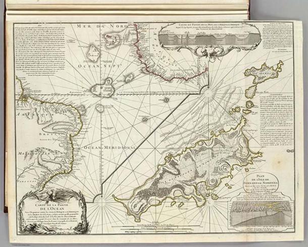
“Map of the Southern Lands contained between the Tropic of Capricorn and the Antarctic Pole, where the new discoveries made in 1739 to the south of the Cape of Good Hope may be seen” by Philippe Buache. ( Public Domain )
Author, space archaeologist, and independent researcher, William James Veall has taken advantage of Antarctica's present narrow extension of coastal deglaciation and used remote sensing satellite photography to expose a number of absolutely astonishing human heads and animal portraits together with inscriptive material clearly demonstrating someone had touched down on at least three separate areas of Antarctica coastline in the distant past.
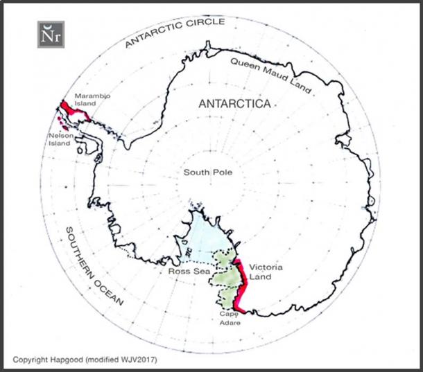
FIGURE 1: Modern map of Antarctica indicating the section of the Ross Sea coastline, the subject of Space Archaeologist William James Veall's probing by remote sensing satellite (in red) and the extended ice-free section of the Ross Sea coastline as shown on the AD 1512 maps of Oronteus Finaeus (marked green).
William Veall continues: Many readers of Ancient Origins already know I use the technique of remote sensing satellite photography to expose ground-based imagery: rock sculptures, intaglios, pictographs, petroglyphs and epigraphy symbols. Currently, I am also involved in using satellite technology for the extremely important service of detection, preservation and protection of archaeological sites world-wide from theft and acts of vandalism. (GlobalXplorer)
- Remote Sensing Satellite Uncovers Astonishing New Evidence of Viking Presence in Newfoundland, Canada
- Sea-Farers from the Levant the first to set foot in the Americas: proto-Sinaitic inscriptions found along the coast of Uruguay
- The Buache Map: A Controversial Map That Shows Antarctica Without Ice
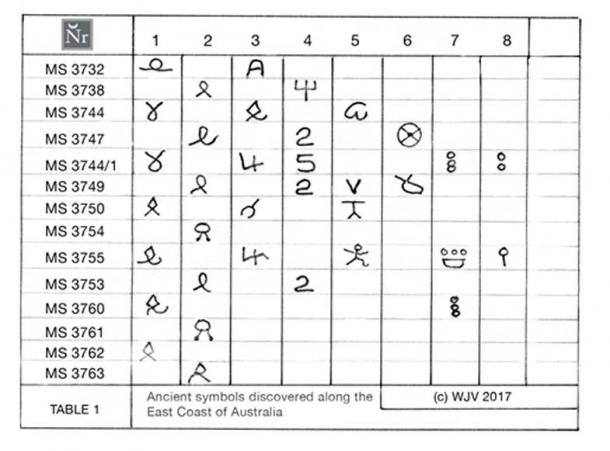
Utilizing this same technique, I have been very successful tracing the coastline 'hops' of trans-oceanic voyagers around South America, the seaboard of North East America, Newfoundland, the West Coast of Africa, Uruguay and even down the eastern coast of Australia (see table 1) with some most incredible revelations.
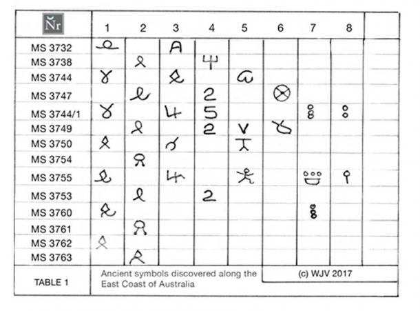
FIGURE 2: Table 1. Ancient symbols discovered along the eastern coastline of Australia by William James Veall, March 2017. (Copyright WJV 2017)
Was Antarctica Once Ice-Free?
Following the rather fruitful foray along the east coast of Australia I decided to chance my luck and put to the test the statement made by the Greek geographer, cartographer and mathematician, Marinus of Tyre who in 400 BC reported he had knowledge of an ancient map depicting Antarctica free of ice.
Logically, the nearest point of any trans-oceanic contact with Antarctica using the eastern Australian coastline as a guide would be to cross the South Atlantic, sail into the Antarctic circle, and come ashore at some point roughly in the region of Wilkes Land; the same area selected by Ross in AD 1840-1843.
It is not unreasonable to assume on the premise that the extreme eastern Australian seaboard runs southwards following roughly the 153º anti-meridian that ancient explorers would have 'coast hopped' this meridian in easily measured steps of latitude known in ancient navigational parlance as 'running the latitudes' in conjunction with certain overhead constellations, thus enabling them to cross the oceans until they reached the continent of Antarctica.
After a preliminary scanning of most of the Antarctic perimeter, a deglaciated section of the Ross Sea region appeared to be the only area that might yield sufficient arcti-factual data to make this 'shot in the dark' have any real significance to answer the question: Are there any signs of indigenous or external activity which may account for the fact that various ancient sea maps purport to show all or parts of the Antarctica coastline free of ice?
So firstly, how did Marinus of Tyre learn of the existence of ‘Antarctica’ in 400 BC and secondly, did Buache really have access to ancient maps which allowed him to construct what he claimed to be a true representation of the continent of Antarctica... minus its covering of frozen ice and snow?
Apparently, it was Aristotle who told Marinus of the existence of a continent named 'Terra Australis' surrounding the South Pole. Marinus then marked the world map he was compiling from other ancient maps with this same title. But, most fascinating of all, his map showed Terra Australis (Antarctica) without the traditional ice shield. However, the ancient maps Marinus allegedly used mysteriously 'disappeared' so we have no way of verifying his story.
By the same token; this does not explain how other ancient cartographers, like Oronteus Finaeus and Hadji Ahmed could also claim they had access to maps 6,000 years old (4000 BC) depicting the continent of Antarctica completely free of an ice cap. From where did their maps originate and who compiled them? I believe I may have chanced upon an answer.
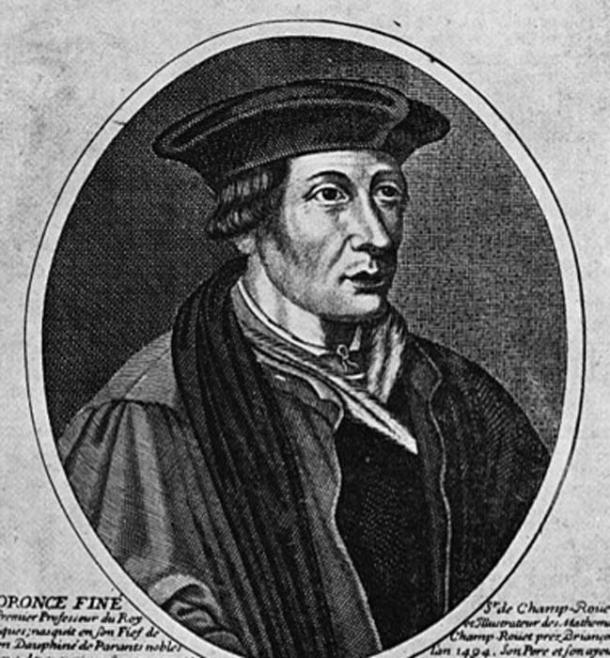
Oronteus Finaeus (or Oronce Finé), ( Public Domain )
Searching the Explorers’ Sea Route
I must confess, prior to my Antarctica 'shot in the dark'—apart from knowing Antarctica housed the South Pole... and a few penguins—I really had no preconceived ideas about this ice-coated region at the southernmost tip of Planet Earth. Imagine my surprise to discover quite by chance I had followed the now familiar 'modern' explorers’ sea route to Antarctica and coincidentally landed my remote sensing satellite probe virtually at the same anchorage chosen by Amundsen (1911-1912) and Scott (1910-1913).
Rounding Cape Adare and into the Ross Sea, I scanned the eastern coastline along a stretch where the Ross Sea borders Victoria Land. Quite coincidentally, a section of deglaciated shoreline had retreated a little inland leaving a roughly two-kilometer (1.24-mile) stretch exposed, albeit, some places still covered with traces of glaciation. According to the most recent scientific surveys, the Eastern Antarctica ice shield has, even over just the last twenty years, begun to melt at an alarming rate suspected to be as a result of global warming.
I had barely crossed the halfway mark along the Ross Sea shoreline when I had the shock of my life!
Human Heads
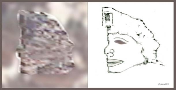
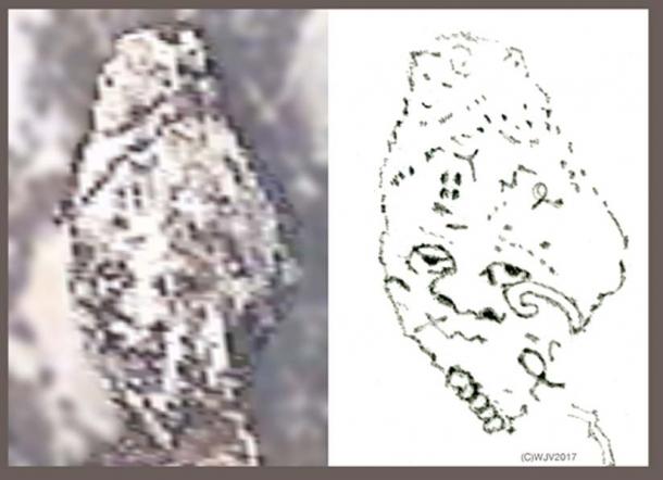
The satellite had captured very clearly a human head image (portrait) staring out from the rocky terrain. (Figures 7 and 7a) This was not supposed to happen: the presence of Mankind in any form, prehistoric or otherwise had never ever been detected on Antarctica—a continent currently believed to have been ice covered for eight to nine million years, and would logically be virgin territory free of any prehistoric indigenous inhabitants until well after the end of the great Ice Age, 12,000 years ago.
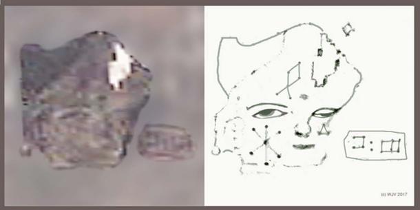
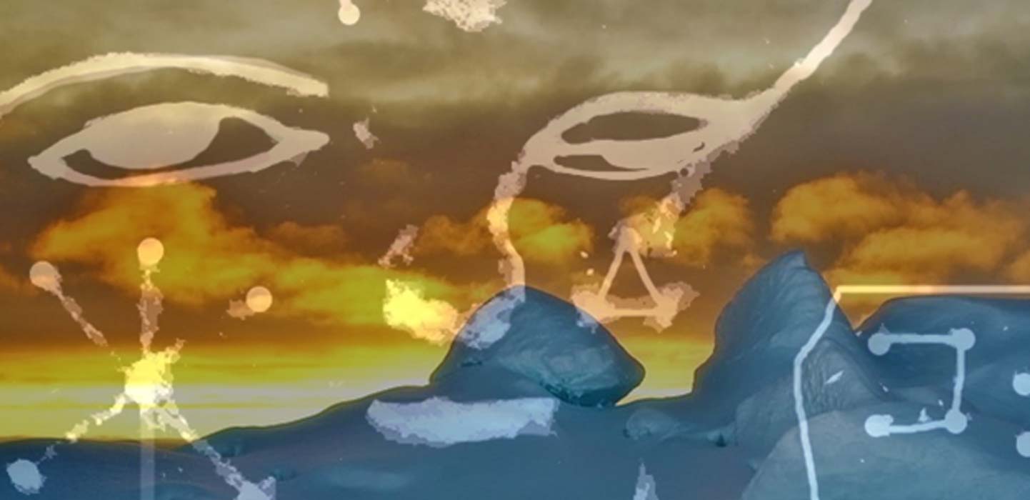
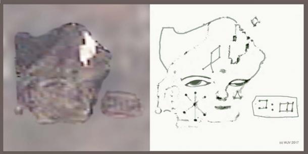
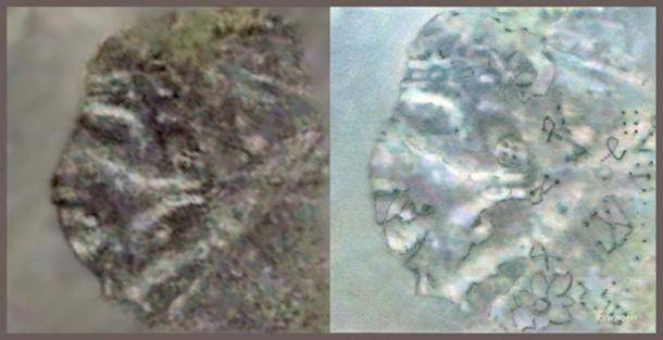
FIGURES 7 and 7a: The very first portrait I discovered on Antarctica; this amazing figure wearing a tricorn hat is carved into a deglaciated rock surface, some 25 meters in height x 32 meters width, it features a human head, Caucasian in appearance, with gentile facial features and lightly epicanthic, expressive eyes. The left cheek (facing) is pecked with a Cretan style 'star'; the forehead with a diamond point GIS. Beneath the right eye (facing) is a small pecked triangle. Just opposite are pecked two Linear A characters.
Research carried out by Reading University in the UK strongly suggests an advanced civilization did exist many thousands of years before the Egyptians, Sumerians or Babylonians; this culture of Black Peoples (the Kiffian Era) due to climatic changes were driven south from their homelands of the "Green Sahara" (9000 – 4000 BC) to eventually merge their allegedly quite advanced technology with the less developed peoples in the southern regions, Egypt, for example. (see References: ' Black Mummy of the Green Sahara' - an excellent video).
Scanning the Ross Sea rocky coastline eventually exposed some forty or so human head portraits, including animal heads and, including those in Table 2, nearly one hundred pecked symbols. My method of analysis has been developed over many years studying literally hundreds of satellite imagery situations across the mountains and deserts of the world, enabling the creation of extremely critical rules for precise imagery interpretation.
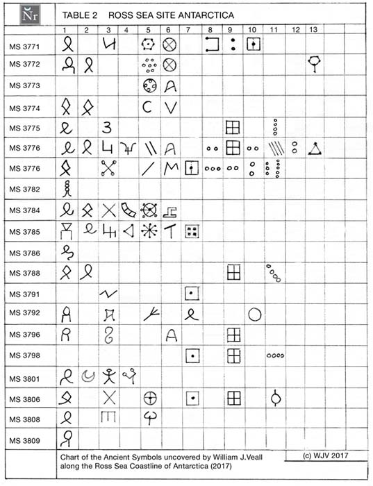
FIGURE 3: Table 2 Chart depicting the ancient symbols uncovered along the Ross Sea coastline of Antarctica by Space Archaeologist, William James Veall in April 2017. (Copyright WJV 2017)
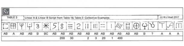
FIGURE 4: Table 3: Comparing Linear A and Linear B scripts from Tables 1 and 2.
[Authors note: The backgrounds to Figures 5 to 12 have been lightly diffused to improve image clarity, but this original satellite imagery has not been retouched in any way. The added silhouette is not intended to be a 'portrait' but simply an aid to identifying the pose of the satellite image. Figs 5 to 12 are published under the Google Earth 'Permissions of Fair Use'.]
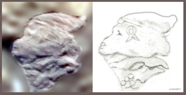
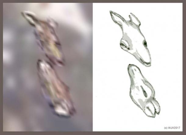
FIGURES 5 and 5a: A petroglyph, located on Marambio Island in the north-west corner of the Antarctic, has a most unusual monkey-face profile, subtending the head of an eagle. The head is marked with an open loop GIS symbol on the left cheek. Three circles (stones) are conjoined at the rear of the eagle's head. A date perhaps?
Which particular culture used this motif as its signature icon to announce its presence on Antarctica? The head is 34 meters high by 50 meters wide (111.5 feet by 164 feet), the Eagle 18 meters high by 39 meters in length (59 feet by 128 feet). The two conjoined 'Gods' appear to represent Hanuman, the all-powerful Hindu Monkey God and the Eagle, the Hindu God, Garuda … but in the ANTARCTIC?
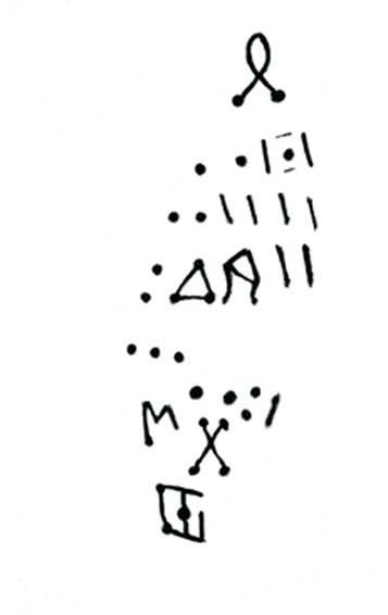
FIGURE 6: I originally ignored this rock-strewn debris but careful maneuvering of the remote sensing camera shot exposed a pattern of rocks seemingly set in the form of an ancient legend embedded into the seashore. Unfortunately, the seaward portion of the text is now submerged under (melt) water. Exposed size 50 meters in length x 25 meters (164 by 82 feet) wide.
Was this message a Dedication to celebrate a long-held dream of stepping ashore on Planet Earth's most iconic land mass; acting as a counterweight to balance Global Earth with another great land mass in the north—the Arctic? I believe so.
The characters appear very similar to the Minoan Linear A 'accountancy' script, circa 1800 – 1400 BC; this is immensely interesting because the 'dots and dashes' just might translate into chronological data, in other words - announcing the arrival and date of European mans' first footfall on the continent of Antarctica?
- The Mysterious Holes of Peru: A Pre-Columbian Domestic Water Source for Trans-Oceanic Travelers? Part I
- Does Socos Pampa Geoglyph Reveal Nasca Lines Were Made Centuries Before Nasca Culture?
Interestingly, Table 3 quite clearly depicts characters are both Linear A and B types, whereas virtually all the subsequent inscriptive material (see table 2) along the Ross Sea coastline is 'pecked' in a more advanced alphabet of Phoenician genre. Thus, by inference, the landing must have taken place well before 1200 BC because after that time the Phoenician genre (1100 BC) began to dominate 'writing'.
One further fact that might confirm that the message was a 'Dedication of Arrival' ; the triangle symbol gives an exact latitude 72 21 04 00 S and longitude 170 15 37 00E. In my experience, a triangle followed by a capital 'A' almost always signified a geodetic of importance.
Further, why set this co-ordinate on a fragile shoreline when all others are carved into the cliff face? Answer: many years earlier the coastline was greatly extended, as proven by both the Oronteus Finaeus and Buache ancient maps (see Figure 1 map, green extension).
FIGURES 7 and 7a: The very first portrait I discovered on Antarctica; this amazing figure wearing a tricorn hat is carved into a deglaciated rock surface.
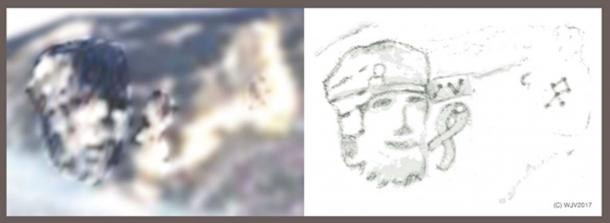
FIGURES 8 and 8a: This figure, 23 meters high x 20 meters in width is clearly of 'Native' ancestry. The head appears to have an unusual projecting jawline. A gnomon records the 170.16.26.00 longitude co-ordinate of this particular image.
Reading the back history of Antarctica, references clearly state that there was never any indigenous flora and fauna of any kind present on the continent because the land mass had been completely covered in an ice sheet for at least nine million years... before even prehistoric Man.
Space archaeologist and independent researcher, William James Veall is Director of Nascodex and Consultant to
Regards


