List members , this is an astonishing new discovery .
I can tell you , even locals there don't really know anything much about the origin of these Geoglyphs . That just adds to their enigmatic mystery...!
**I will add a couple of observations here for a better perspective - the legendary Vedic river Saraswati which dried up thousands of years ago , once used to flow through this very region , right along the present day India-Pakistan border...the ancient Indus Valley site of Mohenjo Daro (now in Pakistan) by the Indus river , is barely 200Km away from these ENORMOUS petroglyphs...hmm , definitely some food for thought !!
***43 Megaliths have also been found in this border region of India's Jaisalmer . Such prehistoric Megaliths are also found in Balochistan and Sindh provinces of Pakistan .
French Scientists Find Geoglyphs, 43 Megaliths In Jaisalmer Villages | Jaipur News - Times of India.
https://www.ancient-origins.net/news-history-archaeology/thar-desert-geoglyphs-0015375

UPDATED 27 MAY, 2021 - 22:47 SAHIR
World’s Largest Geoglyphs Found in India’s Thar Desert
The Thar Desert, or the Great Indian Desert, is a part of India’s national heritage, located in the western state of Rajasthan, spread over a whopping 77,220 square miles (200,000 square kilometers). Two independent researchers from France conducted a meticulous survey of the desert using Google Earth and drones leading to the identification of 8 Thar Desert geoglyph sites in the Jaisalmer district. The clear-cut geometrical lines and arranged motifs of the Thar Desert geoglyphs are now the largest ever graphical depictions by humans in the world!
Ancient Medicinal Mint Has Untapped Potential, New Research Reveals
"So far, these geoglyphs, the largest discovered worldwide and for the first time in the Indian subcontinent, are also unique as regards their enigmatic signs,” Carlo and Yohann Oetheimer write in their study published in the journal Archaeological Research in Asia . The previous record was held by “The Marree Man” in Australia, which is 4,200 meters (2.6 miles) long, but the discovery in the Thar Desert covers an area of 100,000 square meters, easily surpassing all prior records.
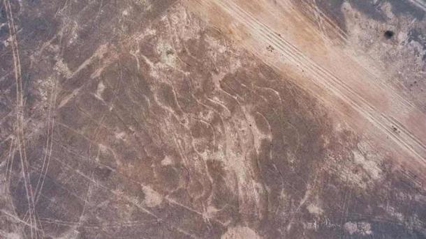
An aerial view of one section of the immense Thar Desert geoglyphs in the desert of Rajasthan, India. (Carlo Oetheimer and Yohann Oetheimer / Archaeological Research in Asia )
The Immense Thar Desert Geoglyphs: Found With Drones
Geoglyphs are land or rock art motifs, which are very large and generally bigger than 4.4 yards (4 meters). The Nazca lines in Peru (500 BC – 500 AD) are the world’s most famous geoglyphs.
- Ten Amazing and Mysterious Geoglyphs from the Ancient World
- Ancient Geoglyphs of Kazakhstan: The Mysterious Markings in Danger of Destruction
But the Thar Desert geoglyphs are so immense that their creators were unlikely themselves to have ever gotten a full picture of the entire art landscapes they made, according to Science Alert .
Using drone technology and data collected in the field “the exceptional character of the graphic patterns near the village of Boha” were revealed. The two distinctly tremendous figures, titled Boha 1 and Boha 2, respectively, depict “a giant spiral adjacent to an atypical serpent shaped drawing” connected together “with a cluster of sinuous lines.”

Huge geoglyphs etched into the Thar Desert. (Carlo Oetheimer and Yohann Oetheimer / Archaeological Research in Asia )
The Thar Desert geoglyphs lines are etched into the ground, 10 centimeters (4 inches) deep, and ranging from 20-50 centimeters (8-20 inches) in width. Boha 1, the giant asymmetrical spiral, is made from a single looping line running for 7.5 miles (12 kilometers), over an area 792 yards (724 meters) long by 220 yards (201 meters) wide.
On the southwest side of Boha 1 lies Boha 2 a serpentine figure recognized by a huge 6.8-mile (11-kilometer) line that forms the outer body of the serpent. A smaller spiral is located within Boha 2, as well as boustrophedon-style line sequences, a style of drawing in which alternate lines are reversed.
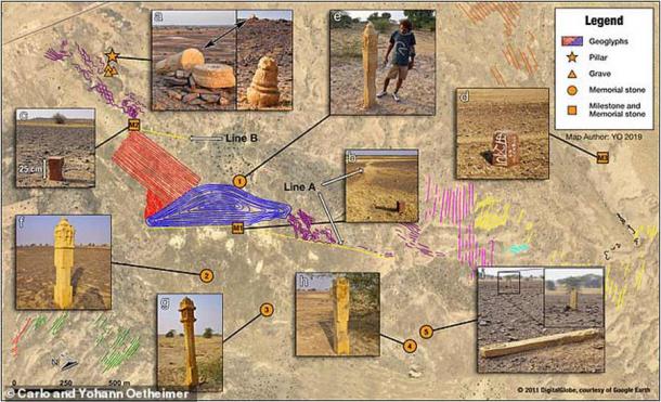
The Hindu memorial stones located around the Thar Desert geoglyphs suggest an advanced form of mathematics, design and planimetry related to the glyphs near them. (Carlo Oetheimer and Yohann Oetheimer / Archaeological Research in Asia )
Thar Desert Geoglyphs: Cultural or Religious Site?
The other Thar Desert geoglyphs are also magnificent but likely of lesser importance. Boha 3 is a series of meandering lines 30 miles (48 kilometers) in length, which the research duo suspect extended to 50 miles (80 kilometers) when first “drawn.”
- Some Giant Geoglyphs in Jordan are Older than the World Famous Nazca Lines
- Blythe Intaglios: The Impressive Anthropomorphic Geoglyphs of the Colorado Desert
"The giant spiral and serpentine figure are definitely the major points of interest, closely connected to Boha 3, suggesting that all the other geoglyphs were created as a framework for this set. Due to their spatial contiguity, patterns 1, 2, and 3 can be perceived as a sequential project.”
Although they are of interest due to their immense size, the Thar Desert geoglyphs are only believed to be 150 years old, and possibly linked to the Hindu memorial stones surrounding them, though their function and meaning are yet to be learnt or understood. Even the source of these geoglyphs and the artist behind them are unknown to the researchers, who hypothesize that it could be a yet-unknown cultural practice or an undiscovered spiritual art form .
“Because of their uniqueness, we can speculate that they could represent a commemoration of an exceptional celestial event observed locally. We remain convinced that these unique geoglyphs are closely connected to their geographical and cultural context, and possibly contain a universal message linked to the Sacred and the cosmos,” the researchers stated, suggesting religious, astrological or cosmological meanings.
At the same time, it would be important to acknowledge the world of possibilities that either of these speculations could lead to including a keen understanding of mathematics, design and planimetry by the creator(s). Planimetry is the study of plane measurements like angles, distances, and areas, independent of those features that are elevated, like roads, rivers, and lakes.
Going forward, it is important to note the role of technology, including drones and Google Earth, in this find and how these technologies can benefit future archaeologists, historians and scholars. The combination of Google Earth satellite tech, drone technology, and field research may reveal other fascinating historical and cultural things that are hidden from plain sight.
Top image: Lines in the sands of the Thar Desert caused by nature’s wind patterns are endless and natural, but the recently discovered Thar Desert geoglyphs are the largest in the world made by human hands. Source: Patrick Ranz / Adobe Stock
Regards
