Basically, we are looking at the phenomenon of hidden, underground pyramids.
And what is the implication of this on what seem to be pyramids on the Moon, if they are not all as obvious as the ones in Egypt? The ones in the crater Aristillus are even arranged in straight lines, of all things!
There are always tunnelways below these constructions that nobody finds the end to, at least this has been the case in Egypt.
Pyramids
The
pyramidal shape of these structures are not typically brought to your attention
in science class in school, nor do you see reports about ...
Another one from Loren. Remember that tunnel systems are typically reported below pyramids. This suggests that pyramids are markers to underground worlds.
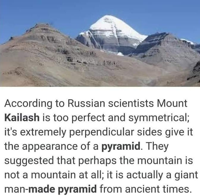
I had send this image of Mount Kailash a little while ago, on this very thread. But the one immediately above is a closeup, and the smaller temple in front of it is very visible. And it is very obvious that the smaller temple in front of it is a man-made, or a celestial made, construction. The pyramid in Egypt is a pip squeak by comparison.
What must be below it! The tunnel systems and cavern worlds must be stunning.
Yes, these are very interesting. I've seen similar conjectures from other various places before. There is even much to be discovered in places like North America I have heard and believe where landmarks and underground structures have been hidden for many hundreds or thousands of years...
Sometimes I drive by "hills" and various places that just seem too perfect or peculiar to be nothing more than natural land formations from "glaciers."
@deandddd , @Soretna , here's an article I found about a Russian researcher's detailed work on Mount Kailash and the Global network of Pyramids - you may find this very interesting :-
When a Russian doctor tried to crack the mystery of the abode of Lord Shiva
Mount Kailash is sacred for Hindus, Buddhists and Jains. Source: Ondřej Žváček/wikipedia
Dr Ernst Muldashev, a Russian ophthalmologist based in Ufa, came up with a theory that Mount Kailash in Tibet is actually an ancient manmade pyramid that is surrounded by smaller pyramids and is linked to pyramids in Giza and Teotihuacan.
Standing at 6718 metres above sea level, Mount Kailash in Tibet is considered sacred by Hindus, Buddhists and Jains. Hindus believe that Lord Shiva, the destroyer of evil, sits in perpetual meditation on the mountain. Tibetan Buddhists believe that the Buddha Demchok, who represents supreme bliss, lives on the mountain.
No human has managed to scale Mount Kailash. There have been many legends of people dying in the attempt to climb the mountain. The Chinese authorities, knowing the religious sensitivity of the matter, have officially banned alpinists from attempting a climb.
Russians, like Indians, have been fascinated with the mountain for a long time. Nicholas Roerich wrote about Mount Kailash and one of his most famous paintings portrays the path to the mountain.
There are several legends about Russian climbers in the 19th and early 20th centuries trying to scale the mountain and vanishing. A Siberian mountaineer once told me about a group of climbers who climbed beyond a particular point and suddenly aged by a few decades. According to his story, they died of old age a year later!
Roerich believed in the existence of a mystical kingdom called Shambala in the vicinity of Mount Kailash. Some Hindu sects refer to Shambala as Kapapa, and believe that perfect people reside there.
In 1999, Russian ophthalmologist Ernst Muldashev decided to go on an expedition to Tibet to try and discover the secrets of Mount Kailash. His team comprised of experts in geology, physics and history.
The team met several Tibetan lamas and spent several months around the foot of the sacred mountain.
Manmade pyramid?
Muldashev’s team came to the conclusion that Mount Kailash is actually a massive man-made pyramid that was built in ancient times. He claimed that it was surrounded by many smaller pyramids and could be the centre of all paranormal activities.
Dr Ernst Muldashev. Source: Mikhail Fomichev/TASS
“In the silence of the night, there often were strange gasping sounds in the belly of the mountain,” Muldashev, author of ‘Where Do We Come From?,’ wrote in an academic paper. “One night both my colleagues and I distinctly heard the noise of a falling stone that undoubtedly came from the interior (of the mountain).” He suggested that some beings lived inside the pyramid.
“In Tibetan texts it is written that Shambhala is a spiritual country that is located in the north-west of Kailash,” Mulsashev wrote. “It is hard for me to discuss this topic from a scientific point of view. But I can quite positively say that Kailash complex is directly related to life on Earth, and when we did a schematic map of the ‘City of the Gods,’ consisting of pyramids and stone mirrors, we were very surprised – the scheme was similar to the spatial structure of DNA molecules.”
Mohan Bhatt, a Sanskrit scholar based in Mumbai, says the Ramayana also refers to the sacred mountain as a pyramid. There are also references to the moutain in the vedas he adds. “The ancient texts refer to the mountain as a cosmic axis,” he says.
Muldashev believes that the pyramids were built by ancient and advanced people who knew about the laws of subtle energy. He wrote that the mountain is the most important part of a system of ancient monumental structures and is directly connected with the main pyramids of the earth such as the pyramids of Giza and Teotihuacan.
Onwards to the Past, a Russian-English bilingual website explores this theory in great details.
The Chinese authorities were quick to dimiss Muldashev’s claims.
A year after his expedition to Tibet, Muldashev claimed to have successfully transplanted a human eye into a blind woman using a harvested cornea and retina combined with an alloplant is an experimental, chemically processed biomaterial primarily made from deceased human flesh. These claims have also been dismissed by doctors in the UK.
Muldashev, who was born in 1948, runs the Alloplant Russian Eye and Plastic Surgery Center in Ufa.
Tailpiece
As an agnostic person who has no clue about the mysteries of the universe, I don’t know what to make of these claims about Mount Kailash. It does make me happy to know that the Chinese government respects the sentiments of Hindus and Buddhists worldwide and will not let anyone try and scale Mount Kailash- which is also referred to as a Stairway to Heaven.
Kailash is a sacred Tibetan mountain shrouded in mystery and legends. Perhaps, this is the only currently peak which no man has gone before. Approach Kailash not only prohibited, but dangerous. In the immediate vicinity of mountains time flows much faster, and people have gone to the mountain, often not returned.
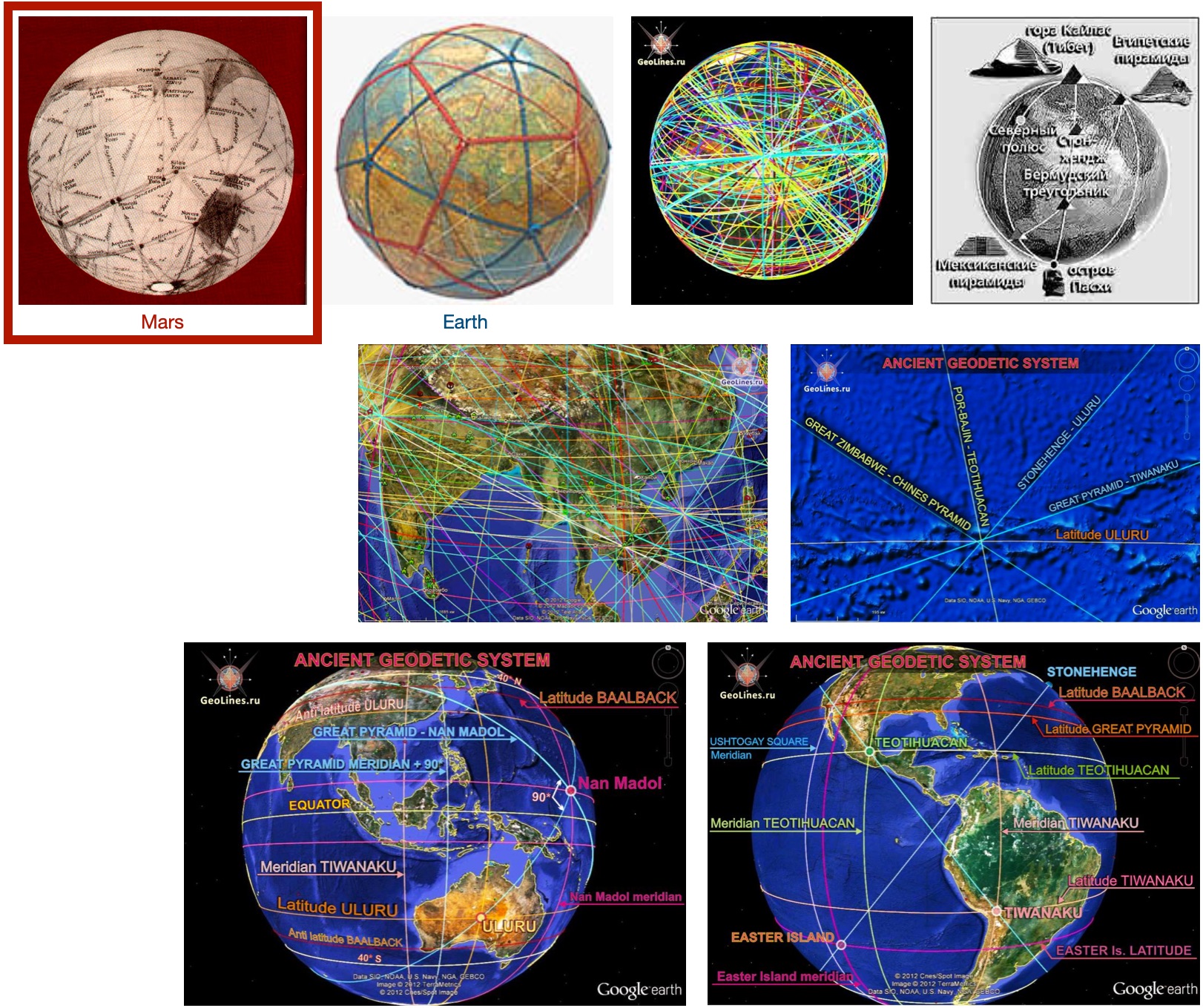
Kailash has a pyramidal shape, close to the right, and there is little doubt that this is the pyramid. For the first time that the Pyramid Kailash can be linked with other pyramids on our planet began to speak in the 80s. Indefatigable researcher Ernest Muldashev proposed his own system of pyramids and described it in his book «In search of the city of the Gods». But probably because in those days there was no program Google Earth, to build the lines he had to use a globe and thread, and «system» to put it mildly, was conditional. But in the main he was right. The Kailas Mountain really is the important point of the System Ancient Monumental Structures (SAMS), it is directly connected with the main pyramids of Earth and other key objects.
But probably would be correct to say on the contrary, this ancient structures and pyramids are associated with the mount Kailash, because it existed long before the pyramids. No doubt that, via a certain points, the System of connected to the mount Kailash.
Look at the location Kailash relative to other objects. The first thing we see is the location Кайласа on the Meridian of Teotihuacan. Meridian Mexican pyramids on the reverse side of the Earth passes through the Sacred mountain with an error of less than 14 km.
Therefore (see the article «Geodesy meridians») Meridian Kailash - Teotihuacan is separated from the Meridian of the Great Pyramid (GP) at 50 degrees East along the equator. In addition, point Kailash divides the segment on the Meridian Teotihuacan in the ratio 5:13. This means that from mount Kailas to antipode Teotihuacan over an arc of the Meridian - 50(50,5) degrees, and to the complex Teotihuacan - 130(to 129.3) degrees.
Moreover, the equator divides the distance between the antipode of Teotihuacan and mount Kailas in the ratio 2:3. And this point Kailash lies at the latitude of 31* in the daytime that on 1 degree above the latitude of the Great pyramid. Next, we consider the interaction point of Kailash with Тriangles of Giza. Perm point of this system is equidistant from Kailash and Mohenjo-Daro, and is the apex of an equilateral triangle formed by these points. In this triangle side PERM - KAILASH is 3640 km, and is the base for a distance of Triangles Giza.
Also the base of the triangle - Kailash - Mohenjo-Daro, length 1,346 km, is exactly 12 degrees along the arc of the globe. Thus, the distance from Mohenjo-Daro to Kailash is exactly 1/30 of the circumference of the Earth. The line itself Kailash - Mohenjo-Daro also has very interesting properties, which we will discuss later. Now pay attention to the side of Perm - Kailash. This line passes through exactly Turgojak lake with an island Vera, which are the famous megaliths. And island Vera also equidistant from Kailash and from Mohenjo-Daro, forming another equilateral triangle with sides of 3160 and 3157 km respectively.
This combination of triangles once again confirms the validity of the construction point of Perm in the triangle of Giza, moreover absolutely independent manner, using point - Kailash. But let's go further. Now the side of the triangle island Vera - Kailash becomes the basis for another isosceles triangle with a vertex in another mysterious place Russia - Fortress Por-Bajin, which is equidistant from the island Vera and Kailash. Distances are 2530 and 2546 km respectively. Completes combination of triangles Kailash is a unique isosceles triangle, the presence of which completely eliminates the random arrangement of all these objects.
It turned out that of Kailas, in turn, are equidistant Por-Bajin and White Pyramid (Qianling Tomb) - the biggest pyramid in China. Together, they form an isosceles triangle with the apex at Kailash. In the middle line of the triangle, it is his height, is the direction of the Great Zimbabwe in Africa - a key point of SAMS.
Moreover the base of the triangle that is Line of Por-Bajin - White pyramid is the direction to yet other reference point systems - Uluru.
The image below shows how the whole system looks triangles Kailash.
Now back to the line of Mohenjo-Daro - Kailash. In the picture above we see that in fact, the continuation of this line is the side of the triangle Kailash - White Pyramid. But this is not the case. It is known that in China hundreds of pyramids and all of them compactly located south of the city Xian. White pyramid (Qianling Tomb), which forms a right triangle with the Kailas and Por-Bajin located further south and a little farther north.
It turned out that the line (orthodromy) Mohenjo-Daro - Kailash is tangent to the latitude of Baalbek (ie, reaches its maximum breadth at the latitude of Baalbek), and touch is just near the main cluster of Chinese pyramids.
The line crosses the latitude of Baalbek simultaneously with the meridians of the Nazca lines and Tiwanaku. All these nuances are best seen on the interactive map at the end of this page.
In addition the line crosses the tropics on the meridian of Nan Madol, latitude of Teotihuacan on the meridian GP 135* (90*+45*), the meridian of Lalibela on the latitude of Angkor, latitude the Nazca geoglyphs (15*) on the perpendicular to the meridian of Uluru.
It is easy to see that in this construction appear almost share the same objects that interact with each other. If we remember that the road dead at Teotihuacan precisely oriented towards the Mohenjo-Daro, it will be further evidence of a direct link between these historical buildings. Line of Kailash - Great Zimbabwe, is the height of an isosceles triangle, and also has very interesting properties, is clearly related to the 45-degree parameters of the Earth.
This image is centered on the meridian, deferred by 45 degrees to the east of the Great Pyramid. Line of Kailash - Great Zimbabwe crosses the meridian at this "anti" latitude of Easter Island. Meridian GP +35 degrees crosses the line at the "anti" latitude Samaipata, the meridian of GP+55* on latitude of Baalbek.
Of course, on the back side of the planet line crosses of latitude of real objects. Latitude 45 degrees, line intersects with on the meridian of Tiwanaku, and the meridian of Baalbek on the latitude of the Nazca lines.
In addition, the line of Kailash - Great Zimbabwe is crossed by "anti" the latitude of Great Zimbabwe and the perpendicular to the meridian of Nan Madol, on which is situated the city of Mohenjo-Daro.
You might also notice that the middle line of the triangle Island Verа - Por-Bajin - Kailash intersects with the meridian of GP+45* on the 45th latitude and the meridian at GP+35*, line Perm - Mohenjo-Daro intersects with the breadth of Baalbek.
In this article, we looked at one more subsystem equilateral triangles that form along with Kailas key sites and its interaction with the main system. It turned out that Mount Kailas, thanks to the Island Verа, Por-Bajin and Chinese pyramids connects of Giza Triangles with Western triangles by combining them into a single system of ancient monumental structures (SАMS).
If we assume that such an inter arrangement of objects random, it is contrary to common sense. But the fact of having a legitimate system in the location of ancient structures looks even more fantastic. If you accept it, will have to reconsider the very basis of our history. But, nevertheless, it is. In a word, "Believe your eyes" .
Author: GeoLines.ru At full or partial copying the direct link is obligatory.
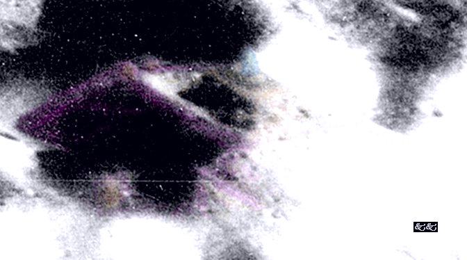
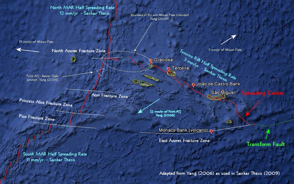
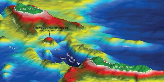
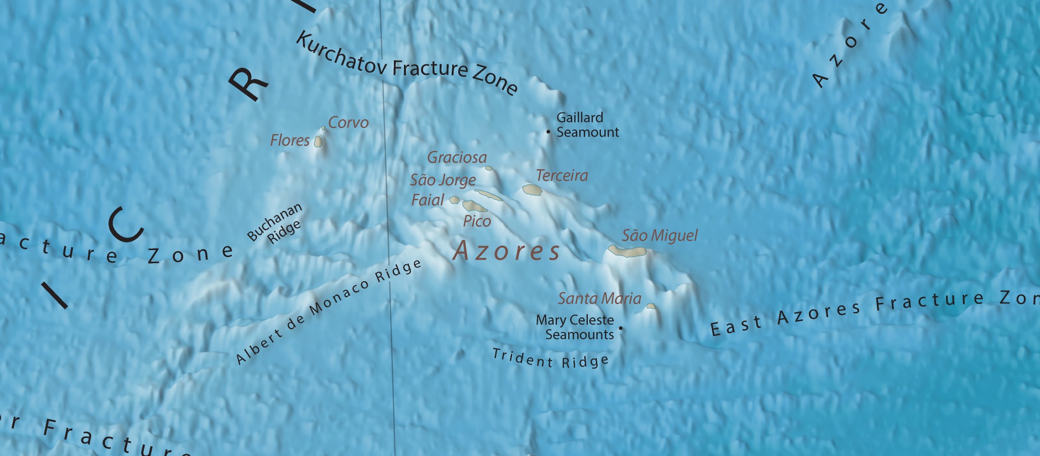
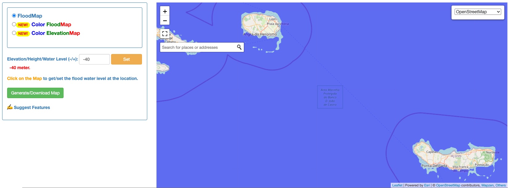
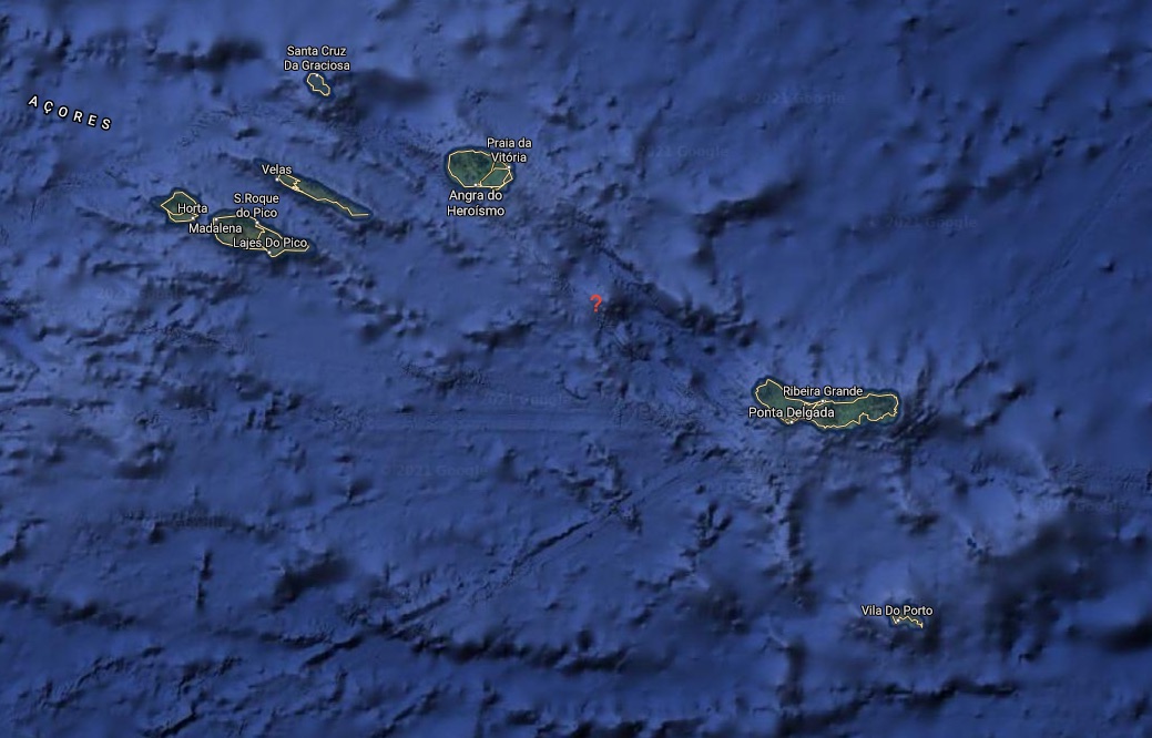
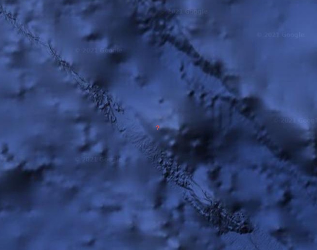
Dean, I found your observation regarding the "giant underwater pyramid" in the Azores to be quite remarkable. This is at or near an underwater volcano supposedly called "Bank De Joao de Castro" (aka "Banco D. João de Castro" aka " Dom João de Castro Bank"). Location between São Miguel and Terceira (reference location maps):
It is apparently (approximately) 40 meters (131 feet) below the ocean's surface. This surprised me somewhat in that that is not that deep below the surface and seems to correlate with other depths we've looked at that I think have to do with Atlantis / the Richat Structure in Mauritania and Frisland / Friesland.
I find it interesting/peculiar that https://www.floodmap.net/ is not showing anything anomalous at this depth since the heights are so variable in this region, so I have to believe that floodmap.net may not be as reliable as I'd hoped before:
I find the images and seeming depth and "fault lines" to be exceptionally interesting here. Very likely to be regions of entrance into the cavern world zone and perhaps interconnected further with the giant evidence of these islands, etc. as previously discussed.
Some estimates say the following: "The pyramid is allegedly 60m high and has a base of 8000 square metres... It was discovered by sailor Diocleciano Silva via bathymetry readings (these are actually a really concept – it’s the study of the underwater depth of lake or ocean floors) and is currently being seriously investigated by these researchers with the assistance of the Portuguese Navy." And they believe "that the area has been underwater for 20,000 years since the last ice age..."
A fascinating analysis of these underwater features , @Soretna .
Folks , at the end of my earlier post in this thread , you may have noticed 3 Links to further articles...well , ALL 3 have their access BLOCKED - hmm...some food for thought as to why they are blocked :)) So , let me apply our reverse psychology here - they are blocked as they are true !!
Yes , thanks @Soretna , I figured that a simple text search might work instead of clicking on those original links...the information contained in these links is ABSOLUTELY PRICELESS !!
***I think this information should be taught in ALL schools & colleges - kids will understand the true nature of our planet much better that way :))
Quite often you can go to Archive.org and use the "WayBackMachine" search function for sites that appear to now be offline, deleted, or otherwise not able to be visited:
If you use the second search down on Archive.org this is where you put book authors, titles, and other content (media) for which you may be search that is NOT a URL for a web site:
So @deandddd you're talking about visually comparing these images of the Mars "canals" vs the 1st archived page with lines on Earth that connect ancient monuments?:
You know, the monuments are usually pyramids, and pyramids accumulate and concentrate energies from within the planet.
And places where energies flow out don’t always have pyramids on top. The cave at São Tomé das Letras in Brazil is so deep that not even an Army expedition found its end; it found branch-offs! There is a slight upslope in front of the cave, and a vehicle in neutral starts to move up the slope. The outflow is causing weightlessness.
Perhaps there are energy flows, energy lines, from point to point; on Mars, too. And perhaps these energy lines show up to our eyes, and in photographs.
Which would imply that the photons are being reflected, and not attracted and absorbed.
I’m just brainstorming. Any perspectives, Sidhartha?

 KAILASH and the SYSTEM of PYRAMIDS.


")