List members ,this article below provides a fairly detailed description of what lies beneath California :-
https://www.thelivingmoon.com/45jack_files/03files/Endangered_Earth_Subsidence_01.html
Endangered Earth
Subsidence
San Joaquin Valley, California
..
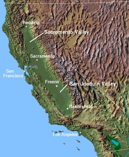
California Central Valley © 2004 Matthew Trump
The World's Largest Sink Hole?
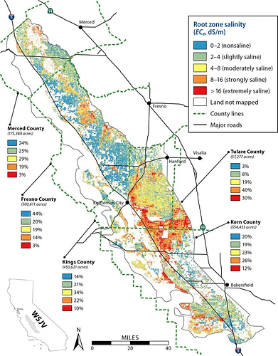
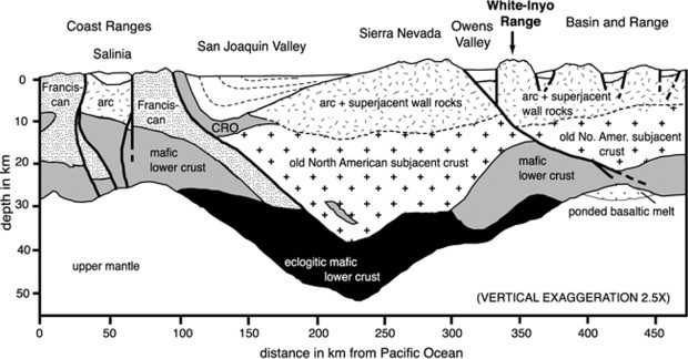
Looking at the above map you can clearly see that the California Central Valley is a long depression. It was formed eons ago by subduction, IE sinking into the Earth. In the article below we first ran into this story that California was riddled with under water caverns that were filled with water and some that had oil or gases on top.
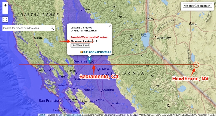
In our search for the "Porous Earth" we have already uncovered hundreds of miles of subterranean cave systems that literally are found under every nation on Earth. Now in the report below it details the caverns from a US Navy point of view... and coincides with our other research on the Submarine base at Hawthorne Nevada and the report below supports that study. We then started on a hunt for some real geological evidence, which we will present below...
The Underground Empire - Branton -- File No. 008
In March of 1980, John J. Williams, a New Mexico "Patriot" who published the anti-Communist oriented "REBEL MAGAZINE" (at the time available from: Consumertronics Co., c/o John J. Williams. Pres., 2011 Crescent Dr., P.O. Drawer 537., Alamogardo, NM 88310) revealed some incredible details on an alleged subterranean system which the Navy had been exploring below the western United States. The report appeared in issue No. 6 of his magazine, and was later reproduced in the Fall, 1985 (#164) issue of SEARCH Magazine, at the time edited by Marjorie Palmer, widow of the late Ray Palmer. The article, titled 'CALIFORNIA FLOATS ON OCEAN?', revealed the following:
"Some time ago, I heard a man on a TV interview-show briefly mention that parts of California and neighboring states are floating on the Pacific Ocean! He was a high ranking Naval officer on a top- secret nuclear submarine that has been (and is) exploring and mapping these enormous caverns and passage-ways underneath the West for over 10 years now.
"A friend of mine finally tracked the man down. He is now living quietly in retirement and asked that no details pointing to him be revealed as he does not want publicity and government attention. After writing this article, I destroyed my files on him. This is his story..."
Williams explains that not "all" of the areas in question are actually "resting" or "floating" on the ocean, however there are allegedly many subterranean cavities below the western U.S., and they are not limited to California, and many of them consist of very large water-filled aqua-systems. These have been explored via nuclear submarines to several hundred miles inland, particularly in the region of southern California and the southern Oregon - northern California area. Williams continues:
"...When he retired several years ago, in spite of about 10 years of intensive Naval study, the Navy had not gotten even a handle on their exacts and dimensions. Today, the story may be different.
"He makes the following statements from his observations:
"1. The passageways are labyrinthine with widths from a few
to thousands of feet (caverns), averaging roughly about a 100
feet.
"2. Much like dry caverns do, heights and depths vary a
great deal and in some cases, two or more caverns or
passageways pass over or under each other at different
depths.
"3. Most of the entrances lie just off the Continental Shelf
(ie. in the Continental Slope - Branton).
"4. Most of the entrances are too small for submarine
investigation; and many that are large enough lie in waters
that are too deep.
"5. Some of the caverns (in S. California) are topped with
oil while some others are filled with gases believed to
approximate our atmosphere (in very ancient times).
"6. The San Joaquin Valley is essentially a portion of the
original cavernous area that collapsed eons ago due to it's
sheer weight.
"7. What is being passed off as the 'San Andreas Fault' are
large, unsupported chambers that are in the process of
collapsing. When the BIG ONE finally hits, many scientists
in the know believe that most of California will break off
like a cold Hershey bar and slide into the ocean! (it is
postulated by some that an ancient land-mass which some
believe may have been connected to what is now California,
broke off and sunk into the ocean during an ancient cataclysm
- Branton)
"8. (We are deleting this section due to the possibility of
undue stress and fear which may result from it's disclosure.
Also, because of recent international events which may have
resulted in a solution to this problem. We will merely state
that it involves a scenario similar to that which was
portrayed in a James Bond movie, and which concerned
underground caverns, silicon valley, nuclear weapons, and the
San Andreas fault - Branton).
"9. A WELL-KNOWN U.S. nuclear submarine lost its way in
these passages and disappeared forever. It was reported to
have been lost IN OPEN SEA ELSEWHERE to keep the American
people in total ignorance and to justify an enormous pay-off
to an eccentric U.S. billionaire (who died in recent years)
for providing the fictitious "recovery" effort.
"I have no reason to doubt the man. I can't tell for sure whether or not these caverns and passageways exist or to their extents. The story does sound a bit fantastic but I have no reason to doubt the man. I have seen copies of documentation that at least prove that he was a high ranking Naval officer (nuclear submarine duty) and a distinguished scientist. In fact, his scientific background and reputation are impeccable. He definitely cannot be labeled as a crackpot, lunatic or publicity-seeker. I would very much like more information on this topic..."
The Geological Proof
Long Beach California
..
Oil Girl
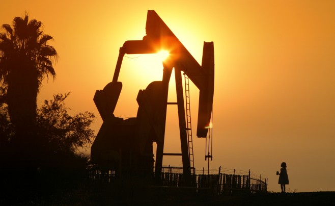
A couple years ago when L.A. had those terrible fires, the sky turned literally orange. I was in Long Beach near the oil pumps. I was walking up this dirt road and this shot revealed itself to me. My intention was to only get the sun behind the oil pump, but then friend's daughter ran ahead and into the shot, and turned it into something I could have never planned. By Patrick Shipstad © 5 March 2007 JPG Magazine
Any one that has ever visited Long Beach California has seen the oil pumps all over the city, near the beaches and even in the port. Where is all this oil coming from? Those very underground chambers mentioned above. Below is an excerpt from the History of Long Beach... the part most pertinent to our study...
In the late 1930s, oil was discovered under Long Beach harbor. Its production helped Long Beach recover from the Depression and provided revenue to support expansion and modernization of the harbor as well as enriching individuals who owned land in the area. As a result when land near the oil field began to sink, those who were profiting from pumping the oil out from under the land resisted any suggestion that there could be a link between oil production and subsidence. They hired experts to defend their position. As the subsidence continued, those whose property was damaged by the sinking, but who were not benefiting from the oil production, hired experts to determine what was really causing the sinking.
While the controversy continued, the land kept sinking. It sunk like a big bowl and the bottom of the bowl was more than 25 feet below its previous elevation. Some warned that if the sinking continued, the ocean might inundate the city. The Navy Shipyard was near the bottom of the bowl and the Navy didn't own the mineral rights of the Shipyard so they were suffering damage but receiving no benefit so in 1958 the Navy sued all of the oil operators. Although the suit was never litigated or settled, it helped to convince many people that a proposed solution, pumping water into the fault blocks where the oil had been taken out, should be implemented. And that solution stopped the sinking.
The production of oil from under the harbor led geologists to explore the area under the tidelands and submerged lands off Long Beach and oil was discovered to be there as well. This discovery led to a struggle between the city, to whom the state had granted the tidelands in 1911, and the state and federal governments over control of the oil revenue. Eventually the state and city were forced to divide the money.
SOURCE: The Virtual Oral/Aural History Archive
![]()
So there we have our first piece of proof... Long Beach is held up by water as they use sea water to replace the oil they take out. The land sank 25 feet in only a few years.
But what about San Joquin Valley?
San Joaquin Valley, California
Subsidence Overview
..
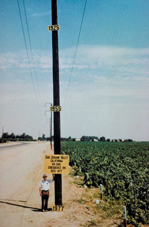
Image from USGS, 1977
They say a picture is worth a thousand words. This illustration shows how much the Valley sank from 1925 to 1977. The photograph above illustrates subsidence in the San Joaquin Valley, California. In the photo, USGS scientist, Joe Poland shows subsidence between 1925 and 1977 due to fluid withdrawel and soil consolidation
Excerpt from
Association of Environmental & Engineering Geologists
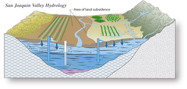
Land subsidence can result from fluid (e.g. groundwater, petroleum) withdrawal in weakly consolidated materials. The loss of fluid causes consolidation of the empty pore spaces, which means that any voids in the soil previously filled with fluid are compressed by the mass of the overlying materials, effectively decreasing the soil volume and resulting in land subsidence. Examples of places experiencing land subsidence due to fluid withdrawel and subsequent soil consolidation include: the San Joaquin Valley, California; Houston, Texas; Phoenix, Arizona; and Venice, Italy.
Geologists and engineers work together to develop computer models of areas undergoing subsidence and monitor fluid removal and subsidence rates in those areas. To avoid damage to new development, geologists identify and study areas containing materials undergoing, or susceptible to, subsidence, then provide recommendations for minimizing or preventing future subsidence. - SOURCE
There are many causes of Subsidence, collapses of natural caverns, collapses of man made tunnels such as mining operations, natural sink holes created when underground rivers wash away the soil beneath, and pumping out of oil pockets and more important, under ground aquifers.
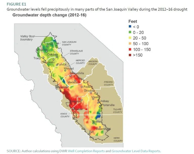
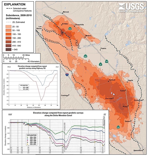
All in all the Earth is VERY Porous indeed. So as this group of enginners shows us, the San Joaquin Valley first created by subsidence eons ago... has sunk over 30 feet in 50 years and is still sinking. Considering how important this area is to food production in the USA, this is very serious
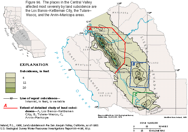
Subsidence due to compaction of fine-grained sediments began in the San Joaquin Valley in the 1920's and in the Sacramento Valley in the 1950's. The area most affected has been in the southern and western parts of the San Joaquin Valley (fig. 93). Approximately one-half of the valley, or about 5,200 square miles, had subsided at least 1 foot by 1977; the total volume of subsidence was greater than 17 million acre-feet. The land surface declined nearly 30 feet from the 1920's to the late 1970's in an area southwest of Mendota (fig. 94). Importation of surface water and reduction in ground-water withdrawals during the 1970's slowed or stopped the decline of ground-water levels. In many cases, this allowed recovery to pre-1960's water levels and prevented further land subsidence.
..
Ground Water Atlas of the United States - Segment 1 California Nevada
A recent U. S. Geological Survey (USGS) report (Galloway and others, 1999) shows that sustainable development of our land and water resources depends on improved scientific understanding and detection of subsidence. The report features nine illustrative case studies that demonstrate the role of subsurface water in human-induced land subsidence (http://pubs.usgs.gov/circ/circ1182). More than 80 percent of the identified subsidence in the United States is a consequence of human impact on subsurface water, and is an often overlooked environmental consequence of our land and water-use practices. The increasing development of our land and water resources threatens to exacerbate existing land-subsidence problems and initiate new one (fig.1).
Land subsidence is a gradual settling or sudden sinking of the Earth's surface owing to subsurface movement of earth materials. Subsidence is a global problem and, in the United States, more than 17,000 square miles in 45 States, an area roughly the size of New Hampshire and Vermont combined, have been directly affected by subsidence. The principal causes are aquifer-system compaction, drainage of organic soils, underground mining, hydrocompaction, natural compaction, sinkholes, and thawing permafrost (National Research Council, 1991). Three distinct processes account for most of the water-related subsidence--compaction of aquifer systems, drainage and subsequent oxidation of organic soils, and dissolution and collapse of susceptible rocks.
-
SOURCE: Land Subsidence in the United States December 2000
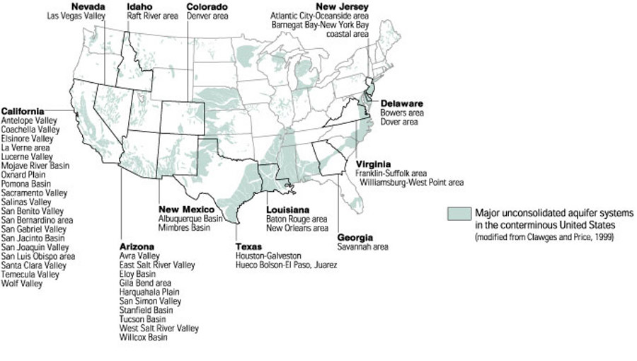
Some Major Aquifers in the USA
.''
Some of the areas where subsidence has been attributed to the compaction of aquifer systems caused by ground-water pumpage. Credit: USGS
Papers:
- USGS Fact Sheet-165-00 - PDF
- Late Neogene Paleogeography and Paleobathymetry of the San Joaquin Basin - PDF
- USGS - Largest human alteration of the Earth’s surface - PDF
- Delta Subsidence in California - The sinking heart of the State - PDF
- Subsidence: That Sinking Feeling - PDF
- NASA - Rapid subsidence over oil fields measured by SAR interferometry
International Association of Hydrological Sciences Proceedings 1976 - PDF
Regards

