continued from Part 1...
Complex super-sonic wave-forms – laboratory.
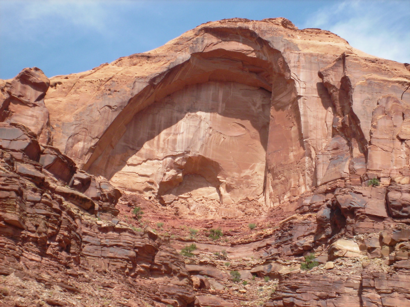
The interior of the dome is the sputtered remnants of lightning diffused mesas and pinnacles, preferentially left behind as the landscape around lifted away in the most intense region of electric field in the eye of the storm.
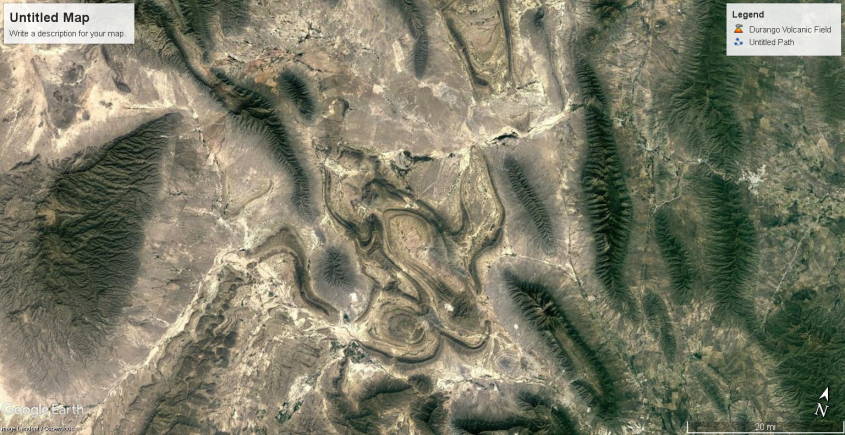
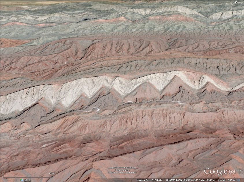
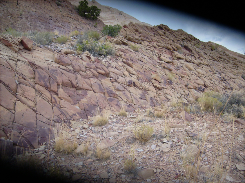
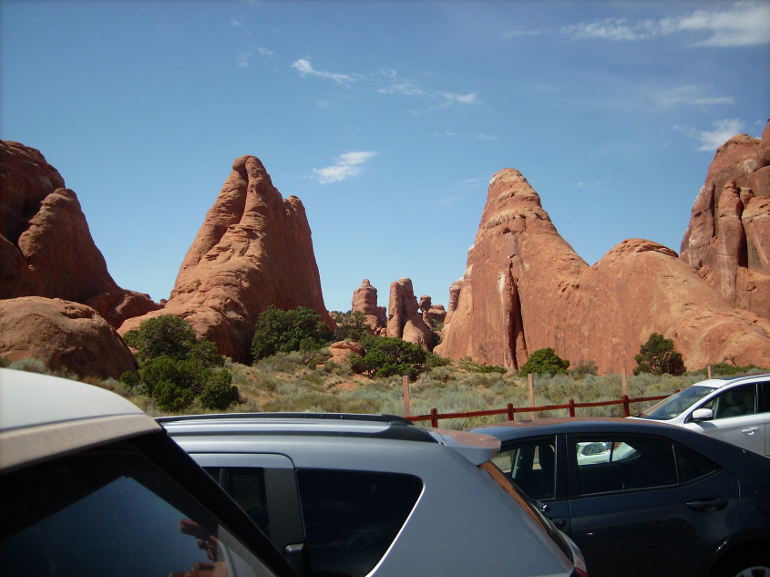
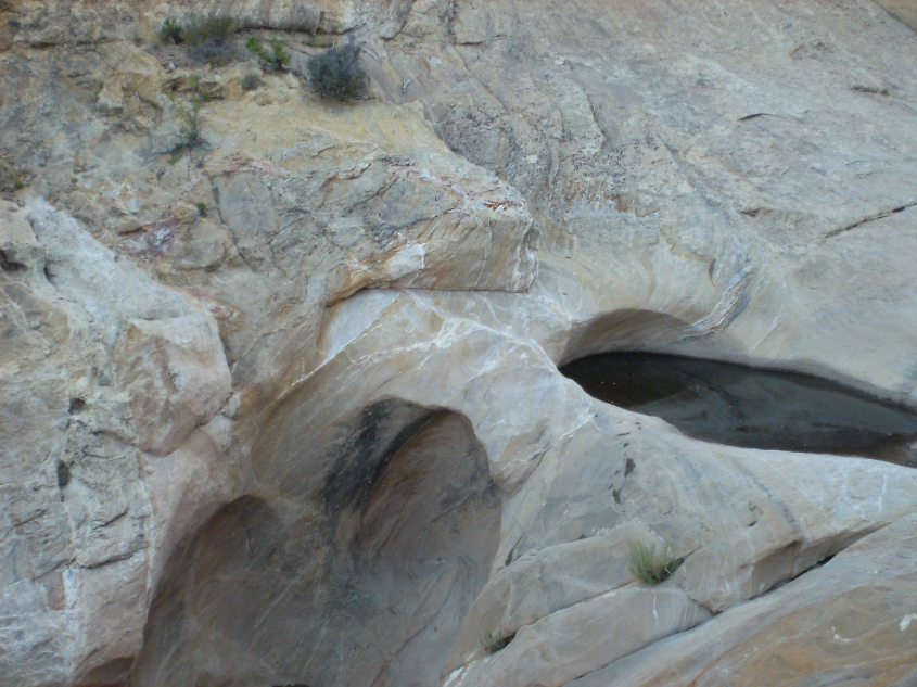
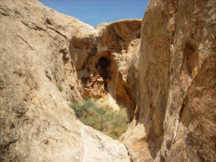
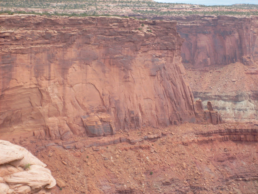
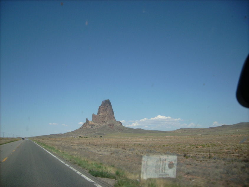
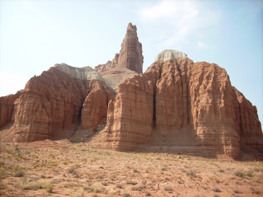
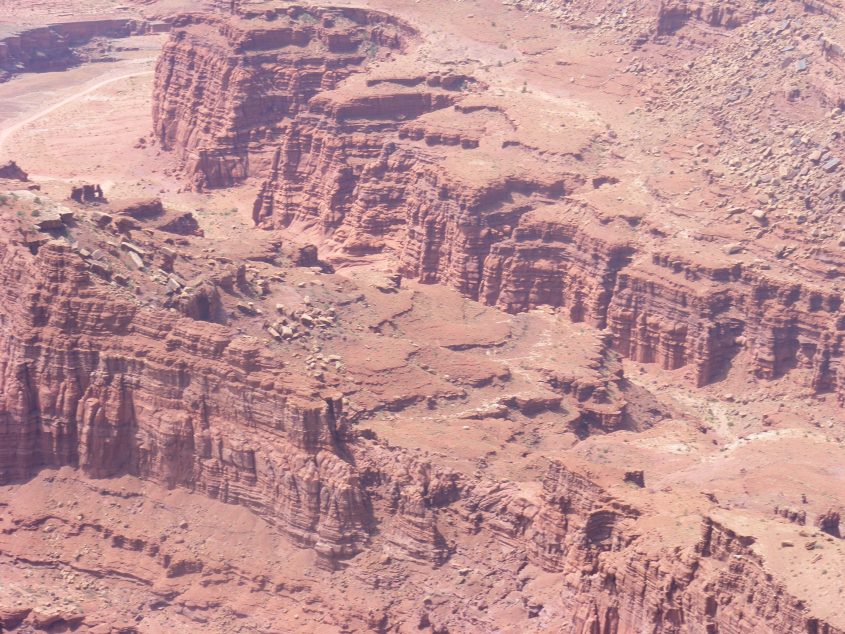
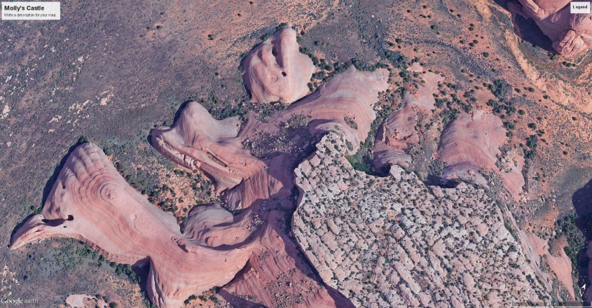
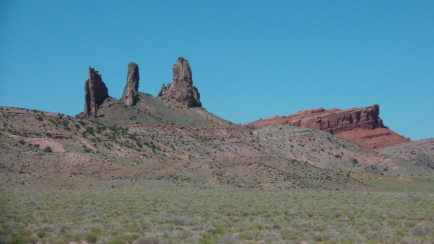
Monument Valley
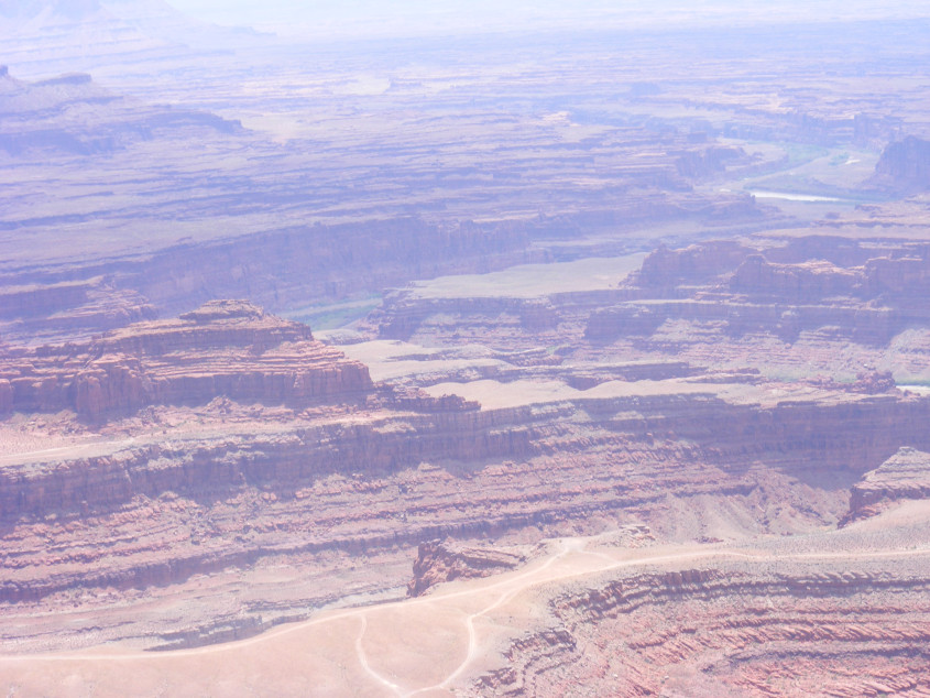
The downdraft leg of the Monument Valley updraft lies in the bend of the San Juan River, as it passes through the Four Corners region.
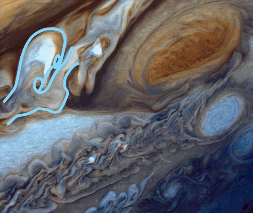
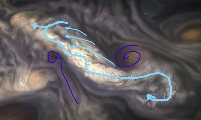
Annotated to distinguish the features, the same eye-glass shape is evident where this coronal loop connects with Earth, but the shape is skewed to the ambient counter-clockwise rotation of the entire storm system. The downdraft lies at 90 degrees to the updraft because this is “ground zero” for the eye of the storm.
The frame is broken, but the lenses are intact. Downdraft at 90 degrees to updraft. In the broader perspective, one can see the circular rotation imprint continues along Black Mesa and defines the eye of the storm.
Note, the San Juan River arcs around the downdraft after it passes through the center of the updraft, just as the tributary of the Green wrapped around the Capitol Reef downdraft crater and then shot through the heart of the San Rafael Dome. These are the fractal forms of surface conductive charge diffusion, or “arc blast”, and the rivers are part of it (which will be discussed in future articles).
Nested Fractal Elements
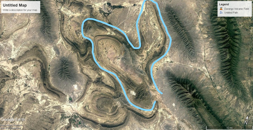
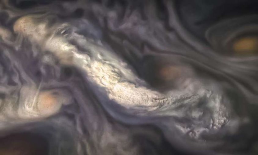
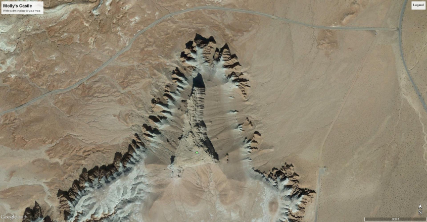
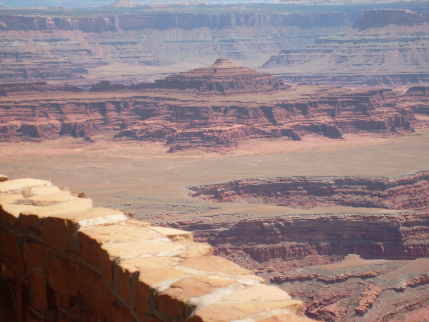
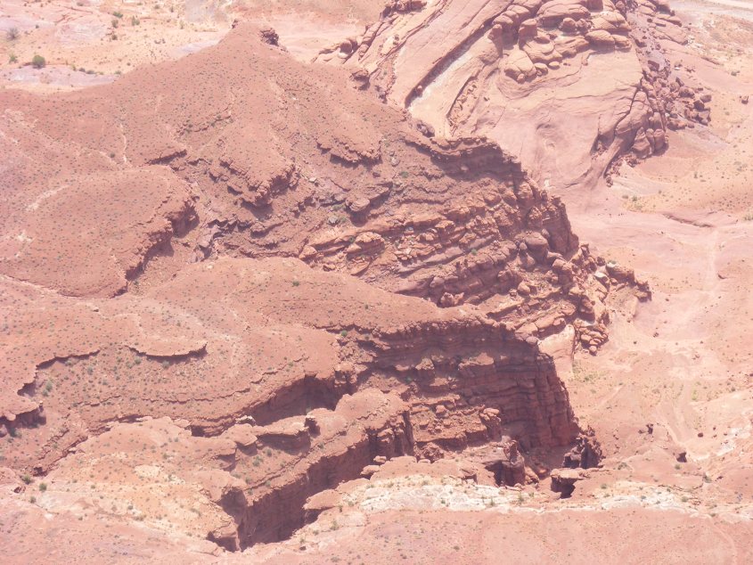
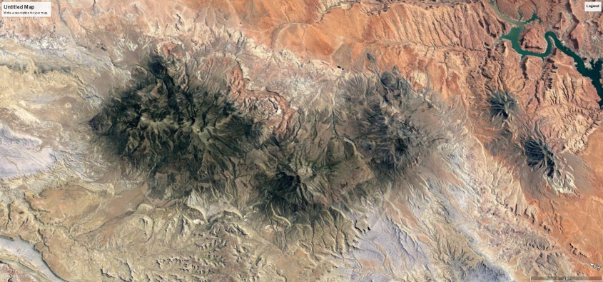
There are fractal repetitions in the up and down-drafts. The most striking example lies smack between the updraft dome and downdraft crater of the San Rafael coronal storm loop.
This butterfly pattern is from an intense loop of current that created an updraft dome (right lobe) and a downdraft crater (left lobe) complete with stratified triangular buttresses to point wind direction; inward and up, or downward and out; respectively. Each lobe is about seven miles across, whereas the San Rafael Dome is about seventy miles across.
Watch this fractal expression expand in scale. Images are taken from a “z” axis in space from a single point on the ground , at varying altitudes.
The fractal repeats, but the center point of each fractal expression stays in place. It morphs in form with emergent effects, but the fundamental circuit relationships remain solidly displayed. They are the same weather patterns we have today, but of super-Olympian scale, as told in countless ancient accounts. We need to start listening to the ancients, because they knew things we don’t.
So let’s recap.
Weather is produced by plasma actions in an electric field that is coupled to ground currents by capacitance. Cyclones and meso-cyclones carry the most violent winds in vertical drafts. In a primordial past, Earth’s weather was like Jupiter’s, due to an amplified electric field. The primary atmospheric actions that shaped the land were: lightning, tornadoes, cyclones, meso-cyclones, sputtering discharge, charge diffusion in solid state matter, and winds stirred by the storms to super-sonic jet-streams. All of these phenomena are electric and fractal.
Lightning and tornadic plasma filaments raise fulgamites and fulgurites. They come in many forms and sizes.
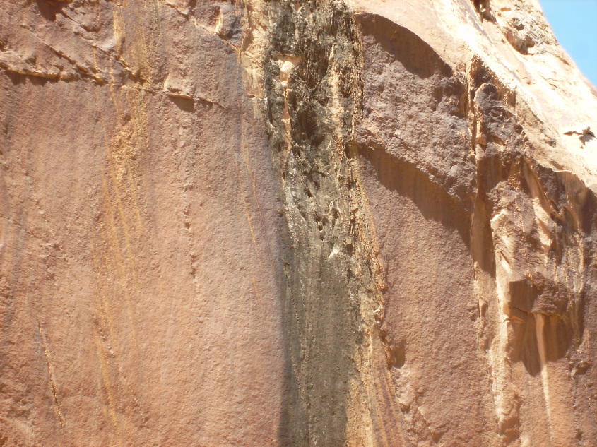
Sputtering discharge eats land away due to charge diffusion through layered sediments.
Supersonic winds form standing shock waves that capture dust in a rarefaction zone called the separation bubble. It forms tetrahedron shaped buttresses behind the interface of the shock wave.
Mirror image mountain chains.
The next chapter will look at ground currents, and the actions and land forms they produce.
Thank you.
Wind Map
If you study Earth’s surface and look at details in it’s form, there are obvious patterns. Arcing patterns of mountain ranges and island chains, strange swirls and looping cracks on the ocean floor, and on close inspection there is harmony in the shape of mountains and other terrain. Sometimes it’s geometric, with triangles, arcs and star patterns, but usually it’s more fluid, like a crazy paisley.
Consensus thought is this results from a series of unrelated events that occured over billions of years, driven by the slow churn of Earth’s crust sub-ducting the continental plates, and the constant wear of erosion. EU thinks it didn’t happen that way. We think it was caused by electricity, and the patterns we see make more sense if viewed in the context of our theory.
The face of the Earth was shaped by three primary means: volcanic eruption, lightning, and wind. It occurred in primordial storms which ionized the atmosphere, charged the ground like a battery, and discharged energy the same way we see today: earthquakes, volcanoes and storms. Only these storms were beyond biblical. They occurred before Man arrived. What we are talking about today are the storms of creation, which shaped the face of the planet.
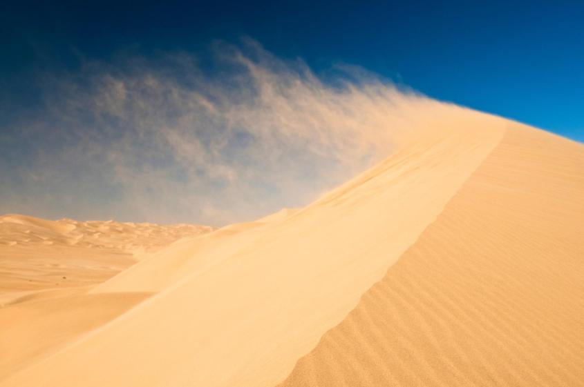
Because wind played the biggest role in laying and piling the sediments we live on, its effects are most visible. The evidence is in supersonic shock waves imprinted on the land. Once you start recognizing the characteristics of wind-formed topography, it becomes impossible to ignore.
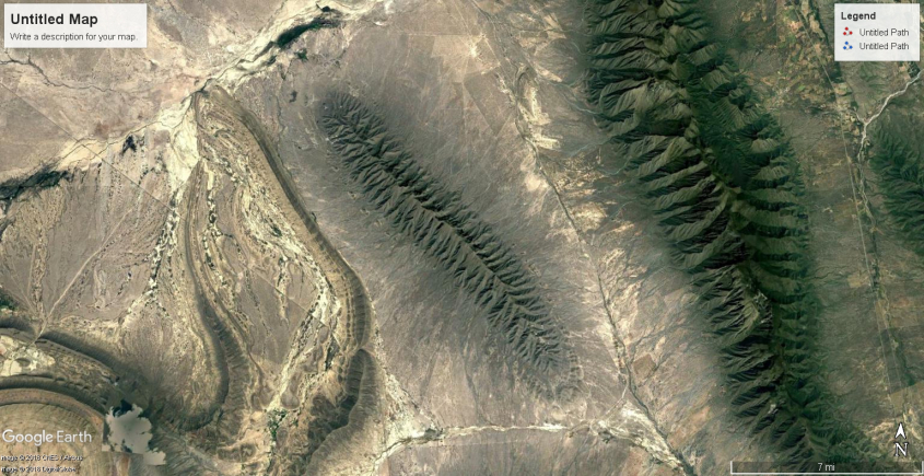
To identify wind direction, look at mountains. Mountains (not volcanoes) are all essentially wind blown dunes. With exceptions for shifting wind conditions, a mountain’s shape will show a windward and leeward side like a dune. The leeward side is generally steep and slab sided, and the windward side dips at shallower slope.
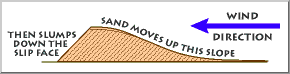
Typical sand dune formation.
The windward side actually portrays the shape of the wind itself, as pressure waves undulate across movable sands and mold them.
If the wind reaches Mach speed, standing shock waves reflect from any protrusion in the wind’s path, causing a sharp change in wind direction. Distinct patterns form at this crease, where the wind direction changes abruptly. The reflected standing shock wave forms a fan-shaped interference pattern of compression and rarefaction. This pattern can be found on most mountain forms, including cordillera mountain arcs, continental divides, lone inselbergs and basin and range.


Dust laden supersonic winds deposit their heavy cargo where the crease in the wind forms. A tetrahedron-shaped zone of rarefaction (low pressure) develops at the root of the standing wave, called a “separation bubble”. Wind-born dust collects in this bubble as the wind deflects upward with the shock wave.
As material deposits in the separation bubble, it forms a new barrier to deflect the wind, which moves the standing shock reflection backwards, into the wind. The separation bubble migrates into the wind with the shock wave, causing new dust to overlay the old in layers that stack into the direction of the wind.
A protrusion in the wind changes the wind vector and angle of reflection, and forces the shock wave to grow backward into the jet stream. This deflection of the wind creates low pressure at the leading edge of the protrusion which deposits buttresses in the shape of the triangular wave-form.
The shock wave is a discontinuity in density, temperature and ionization. Remember, we are talking about a primordial storm where much of the atmosphere ionized. So, standing shock waves reflected from the ground, back into the clouds, providing a path for discharge. The separation bubble is not only a pressure sink, which collects heavy matter, it is also a current sink, being the lowest potential region connected to the high potential current in the reflected shock wave. It therefore draws current to bake, compress and fuse the deposited dust.
It creates a distinct pattern on the windward side. Dragon’s teeth – triangular buttresses, sometimes called flat-irons, formed by the sonic, ionized shock waves of supersonic winds. They rise and fall in amplitude and wavelength, and display harmonic frequency shifts, as well as many, many other features which could only be produced by the sonic effects of supersonic winds – see the “Arc Blast” and “Monocline” articles for more detail.
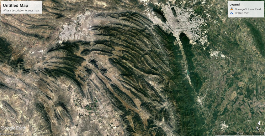
The Mexican Kink
Understanding how winds form these shock patterns, and examining the result on the landscape reveals a wealth of information. Let’s consider this very simple dune, called El Guaje, in the Sierra Oriental mountains of central Mexico. The shock pattern of triangles is very apparent on it’s windward side.
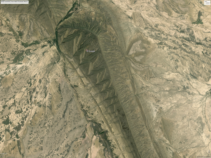
A pressure ridge in Mexico formed by supersonic winds.
The next annotated image of El Guaje highlights four consecutively formed pressure ridges that are visible. The first (green) is almost buried by later deposition and only the tops of it’s buttresses are exposed. The second (yellow) is a minor ridge caused by a period of weaker winds. It is also partially buried by the third, and largest ridge (red).
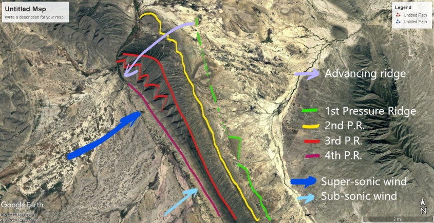
Four pressure ridges can be seen. Wind flow denoted by blue arrows, dark blue denotes supersonic speed.
Large triangular buttresses at one end of the large (red) ridge shrink in amplitude with geometric progression until they almost vanish, indicating the jet-stream velocity transitioned from supersonic to near subsonic velocity along the wind-front of this dune. The faster jet-stream region advanced the growth of the dune, depositing material faster and pushing the shock-wave into the wind. It advanced the ridge line into the wind (violet) and built this portion of the mountain thicker, taller, with large amplitude reflected shocks forming bigger buttresses.
Each layer of the buttresses is formed by a new shock front from winds impinging on the last layer. New shock fronts formed as the winds gusted, piling new layers on the old. A final diminishing wind created a fourth shock front which deposited a small pressure ridge (purple) along the foot of the mountain. The highlights obscure natural features, so please contrast all annotated images with the first, naked image.
The winds that created these ridges were like any storm, just quite a bit more violent. They stiffened as the storm grew, reached a crescendo with electrically charged, gusting blasts at Mach speeds, and then ebbed away. Their formation precludes any notion that the winds that created them were caused by meteor or comet. A large impact might produce supersonic, dust laden winds, but they would crest with the first shock wave and then dissipate, not slowly build to a crescendo.
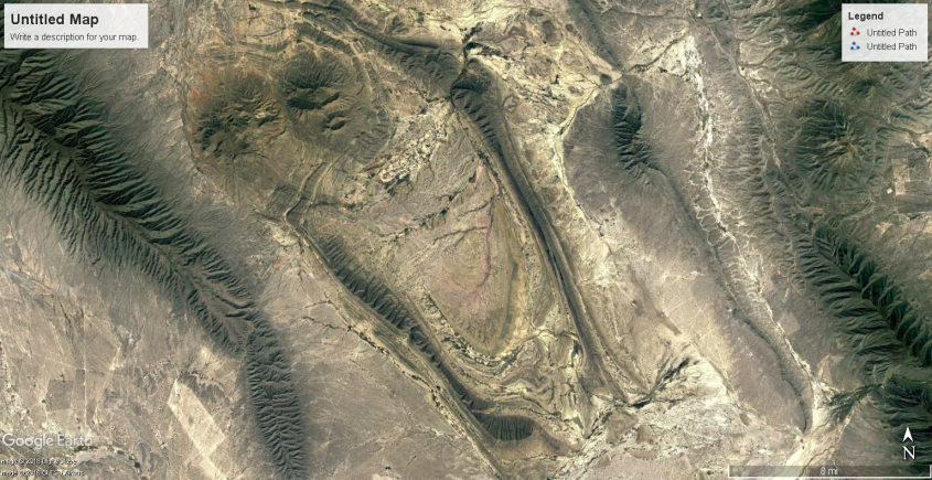
Take a look at the surroundings of El Guaje ridge, and it becomes even more apparent how it was made. It is part of a larger structure – an oblong crater, two hundred feet deeper in the center than outside the rim. The pressure ridges, including El Guaje, form the rim of the crater.
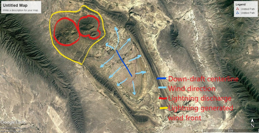
It wasn’t made by an oblong meteor. This is the result of a down-burst wind. The pressure ridges are the rims of the crater, with triangular buttresses showing the wind direction as it blasted the Earth, like a blow torch, and blew out radially, depositing dust along the standing shock waves it created. The outward blast is interfered at the top end by two, round mountains formed by lightning discharge which altered the wind flow around them.
Taking another step back reveals this entire mountain region in Mexico is shaped by a turbulent shear zone in the wind. These mountains were formed by uni-polar winds, screaming from the south, and mixing into plasma storms along the shear zone with opposite polarity winds screaming the other direction. It is eerily similar to the turbulent shear zones adjacent to the Great Red Spot, creating kinked circulations that have a crab-claw shape. I call this the Mexican Kink.
Craters formed by downdraft winds in a turbulent flow region in Mexico. El Guaje is at the very top of the frame, just right of center.
Crab-claw shapes of up-and-down turbulence near the GRS.
Crab-claw shape of downdraft craters in Sierra Oriental, Mexico
Turbulent winds fold back and forth to make these kinks, but they also fold up and down and twist into tornadoes, blowing and sucking at the land. In turbulent zones, the downdrafts form cyclones that are often stretched out-of-round into oval, polygonal and U-shaped structures. The winds are electric currents, so these turbulent kinks are semi-steady-state, keeping their form a long time, molding the land.
Downdraft turbulence also means updraft turbulence. So next to downdraft craters in Mexico are mountains formed by updrafts. Updraft wind will create a dome or ridge of layered deposit with a rim around it also, but the inflow to the updraft leaves triangular buttresses from shock waves on the outside of the mountain, pointing inward.
Linear ridges formed by updraft winds.
The updrafts deposit linear and lobe shaped mountains around and between the downdraft craters. The turbulence is in a shear zone, so deposits occur in narrow lanes between conflicting winds. Updraft deposits are composed of more material than craters and have the triangular patterns of shock wave reflections on the flanks.
As it relates to clouds on Jupiter, a long, rising column like the one highlighted below would create such linear mountains. One can see the dark depths of the hole in the clouds from which the updraft column rises. The winds roll upward from the ground and curl over, leaving a broom-swept linear ridge on the land below.
The roiling updraft, flanked by downdraft cyclones (black regions) creates an “S” shaped fractal form, and raises a narrow mountain beneath it.
The turbulent kinks are fractal forms, so taking another step back reveals the fractal crab-claw shape emerging at a larger scale. The smaller feature with the crater shown above is nested within this larger repetition of the wind pattern shown next, aligned along the same axis. Nested fractals are very evident in Jupiter’s clouds as well.

Shear zone turbulence between conflicting, ionic winds.
The similarity between Mexico’s mountains and Jupiter’s clouds is due to capacitance in the planetary circuits. The strongest winds are vertical winds driven by the electric field.
Following is a sample of images taken from the southern leg of storm centers that molded South America, Australia, Africa and Eurasia. The winds pushed and pulled on the land with electric force, literally molding it from wind action above and volcanic action below.
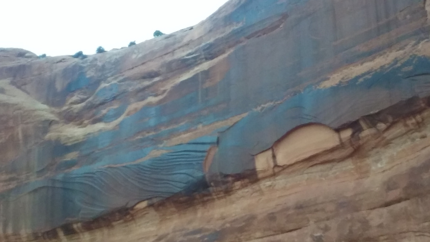
The fluid shapes are a dead giveaway for magneto-hydro-dynamic forces. But deeper levels of evidence are there, in Mach speed sonic shock effects, arcing effects and sputtering effects that provide a holistic electric picture of everything that happened. Look close at the following images and note patterns of stratification and liquid deformation evident from waves of heat and pressure.
Turbulent winds lifting off the land, arcing across the sky, and returning in downdrafts were filaments of plasma that varied in charge density in cross section. Take note how a tornado is a coaxial circuit, with the outer wall of the tube being the fastest, most dusty region, and the inner core often a clear draft. The plasma filaments of primordial storms varied in dust content, charge density, and velocity in cross-section, as well.
Outer and inner walls of a tornado on display.
The result is stratification of mineral deposits vertically, where rock morphology and mineral composition discretely change from the core of the feature, to the walls of the feature and then to the outer surroundings.
The following images show where the storm pulsed and ebbed with current, stratifying layers of dust with different composition from inside-out, where coaxial up-and-down draft winds created domes and craters.
Layers of varying mineral composition are particularly evident where winds abruptly changed direction, from horizontal to vertical at the rim of craters and the buttressed flanks of mountains. There, charge densities in the shock waves and the effects of magnetic pinch were greatest.
Shock formed buttresses in Peru display mineral layering from winds of different composition.
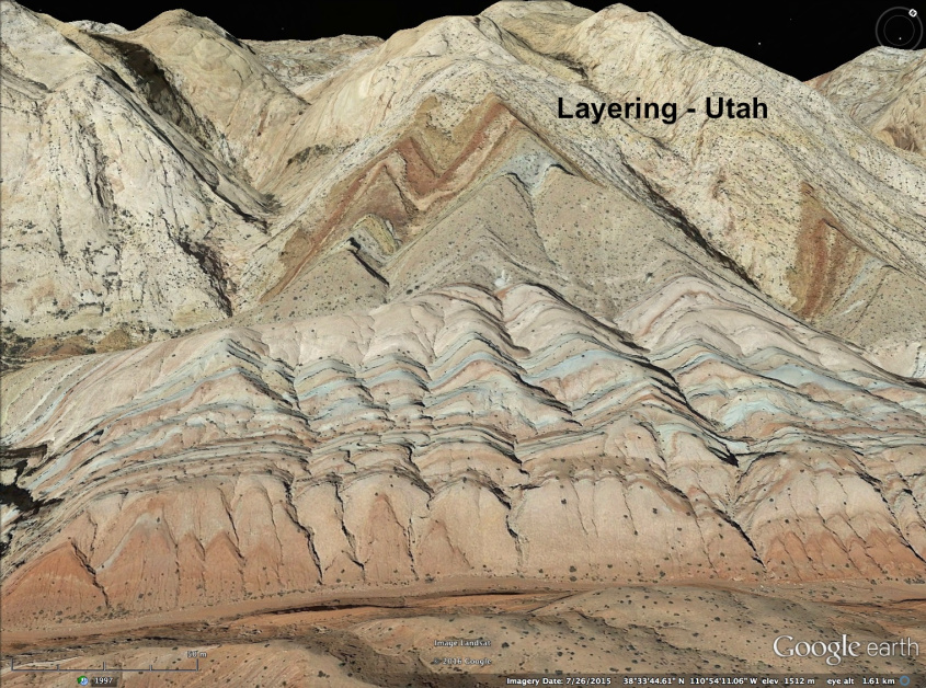
Similar layering is evident in Utah.
The stratification of species within the electric winds of Jupiter matches the pattern of stratification in land forms. They are coherently layered from the inside-out of each turbulent kink, or vortex, unmixed by the turbulence, in accordance with charge densities in currents primarily moving up and down.

Colored patterns don’t mix, but remain stratified in layers according to charge densities and magnetic fields primarily around up and down draft winds. Note color changes define the center, edges and surroundings of vertical turbulence, which is the result of current flows.
That electromagnetic fields sort species and recombine them is predicted behavior in plasma. We use a multitude of techniques in manufacturing based on this fact. Different materials respond to magnetic fields differently. The electric field responds to charge density, so shapes itself around conductive flows of material, and vice-versa. The result is stratification, and it’s apparent the stratification on Earth’s landscapes matches the stratification in Jupiter’s winds.
Earth
Some mountains do not conform to the wind-blown dune shape, exhibiting triangular buttresses on both flanks of the mountain, or not conforming to the windward/leeward angle of slope. This does not mean they are not dunes, but indicates they were formed subject to shifting, or competing winds.
In some cases, mountains formed as sastrugi, or linear deposits parallel to the wind in the shear zone between channels of wind of different velocity.
Sastrugi form parallel to wind flow, in shear zones between different speed winds, especially where turbulent winds laminate in a “bend” – Sierra Oriental, Mexico
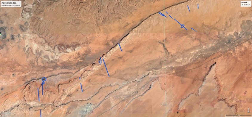
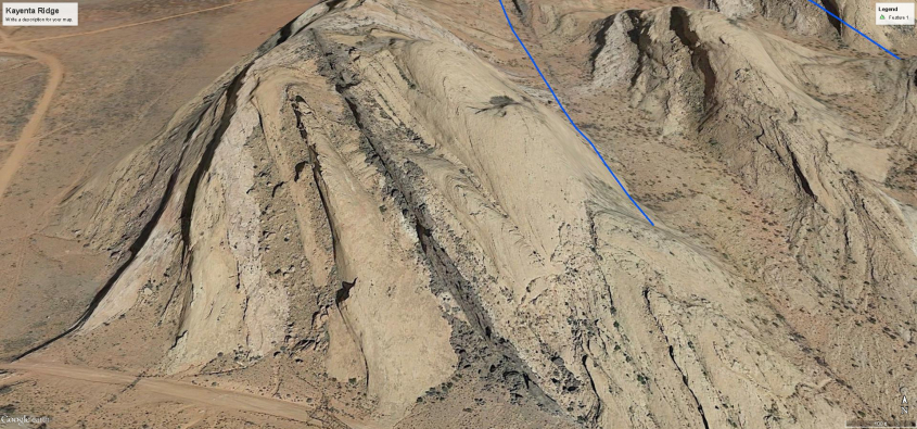
So, it is possible by looking at the land to deduce wind patterns. Following this method, the next image shows the Colorado Plateau with wind formed pressure ridges annotated by blue lines. These are pressure ridges formed perpendicular to the wind. Each line is drawn parallel to a pressure ridge, and perpendicular hash marks indicate wind direction. Red lines indicate pressure ridges formed parallel to the wind, at shear zones between conflicting winds.
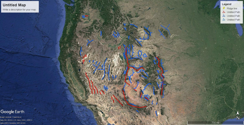
This provides one layer of dimension to the storm. To add another layer, we can look at the domes and craters formed by updraft and downdraft winds.
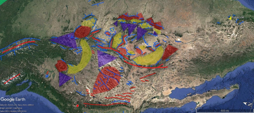
Red areas are updrafts, yellow are downdrafts, blue are precipitation footprints. Adding this layer of information to the map of pressure ridges, produces a wind map of the Colorado Plateau and Rocky Mountains that looks like this:
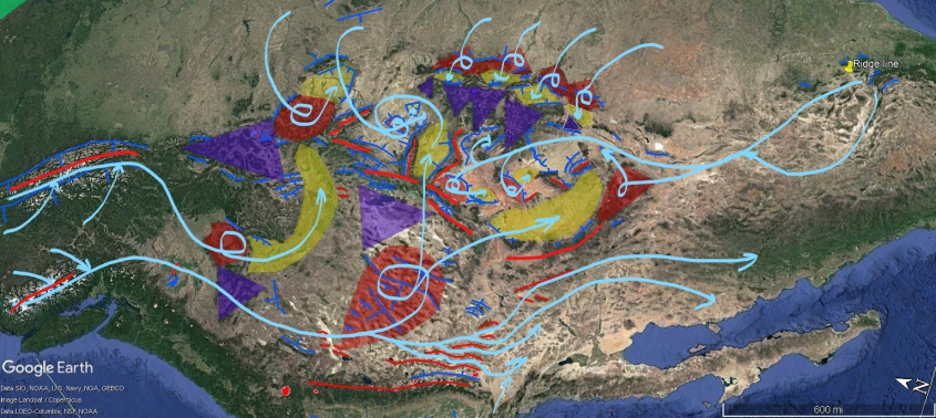
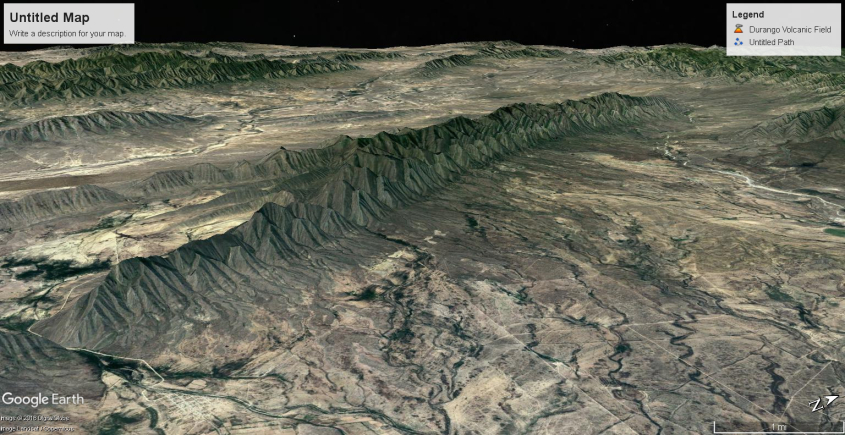
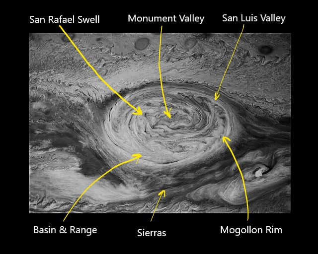
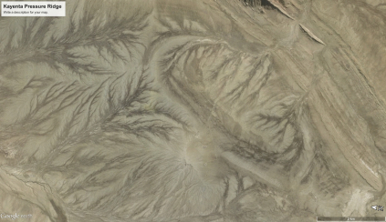
To describe this storm, there are two jet streams from the north. One poured through the Snake River Valley, arcing east towards Yellowstone. The other jet stream swept into the Great Basin rippling Nevada with rows of windblown mountains. An “S” shaped range in central Nevada defines the center of rotation, as this meso-cyclone scraped the ground like one incredible tornado. It down-drafted in two streams. One pressing down on the Uinta Valley, Utah; the other sweeping northern Arizona, forming much of the Mogollon Rim.
The Great Basin thunderstorm also spun air south, bypassing the rotation to help define the Sierra Mountain arc, and scour Owens, Amorgosa and Death Valleys. The Sierras were formed by winds from the west (not shown) which pressed against the Great Basin rotation, and the winds bypassing south.
From the south, winds collected and then split, forming the Mexican Kink, and the El Guaje mountain. They reformed in a ground hugging laminar flow near Four Corners, sweeping across Colorado, Utah and northern Arizona, laying the foundations of the Colorado Plateau.
The southern wind fed a multi-vortex cyclone over the plateau, were it divided it’s path to feed thunderstorm updrafts. These winds threaded up and back down through meso-cyclone-cyclone pairs in looping currents, like lacing a shoe. The updrafts are defined by San Rafael Swell, Utah, and Monument Valley and Black Mesa, Arizona.
Winds from the south also circulated eastward over the Great Plains, to be sucked into the cyclone through thunderstorms that built the eastern face of the Rockies. These down-drafted, forming huge craters in the mountains, like San Luis Valley, Colorado.
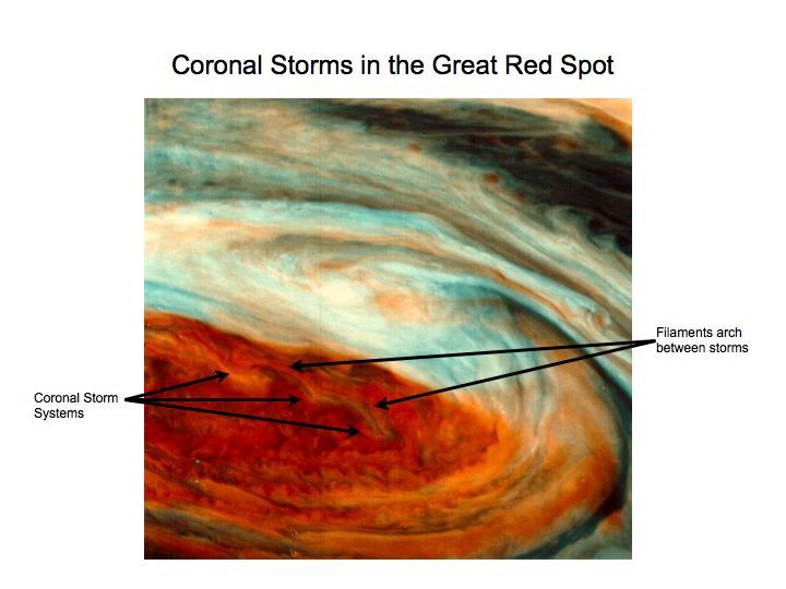
Each of these features – the Great Basin meso-cyclone, the multi-vortex cyclone over the Colorado Plateau, with arching colonnades of meso-cyclone/cyclone pairs can be identified in the Great Red Spot on Jupiter. It’s because the shapes and actions of the wind are driven by the fractal process of charge diffusion in the planetary circuit. The difference in chemistry, and thermodynamics of Jupiter’s atmosphere compared to Earth’s doesn’t make much difference, because circuits are the forcing mechanism in Nature.
So this completes the view of winds at the very eye of the storm. The Colorado Plateau received the hottest plasma torching in North America. Surrounding areas were also ravaged by storm, but none so severely. In fact the whole Earth was wrapped in storms. So, we’ll look closer at some of those regions, as well as more details on North America in the next installment.

Quick Tip
The Daily Plasma is free to read, but the cost of publishing isn’t. Please leave a tip to show appreciation, and help defray expenses.
[
Sputtering Canyons, Part 3
](Sputtering Canyons, Part 3 – The Daily Plasma)
Previously published at Thunderbolts.info
In Part 1 of Sputtering Canyons, we discussed Arches National Monument, and evidence it was formed by a complex sputtering discharge process. That process involved a thermal spiking, barrier discharge in a layer of wet sandstone.
In Part 2, we looked at how charge and charge depletion disperses through rock by the combined mechanisms of current drift and diffusion. We looked at evidence of diffusion patterns in the landscape and evidence of mechanical shear caused by sputtering discharge.
In Part 3, we’ll look at some secondary effects from electrical deposition and sputtering on the Colorado Plateau. These features involve processes besides sputtering discharge and lightning bolts, however. These features also involved the winds of the storm.
In the primordial, plasma typhoon that layered the dome of the Colorado Plateau, winds were mobilized by the Earth’s electric field. Ionic species of opposite charge were pushed in opposite directions. Positive and negative species segregated into streams of unipolar winds that circled the Earth in bands moving alternate directions.
The electric field gradient was from pole to pole, or at least where the poles are now, so the winds circled north to south and south to north. The effect was the same as the counter-rotating bands of wind on Jupiter. Where they met was the anodic hot spot where super-volcanoes belched ash and flame, and the bowels of the Earth spilled forth molten rock.
Between the super-volcanic maw of Yellowstone and the strato-volcanic cones on the Mogollon Rim sits the Colorado Plateau, where the winds mixed in a plasma cyclone. The meeting of the unipolar winds was the earth-sized equivalent of the Great Red Spot on Jupiter – a sustained and violent storm, charged with electricity and bent by magnetic fields – a storm beyond any Biblical description.
Like Jupiter, the winds screamed at several hundred miles per hour. Mach effects, like standing shock waves and supersonic shear created extreme pressure, density and temperature differentials. Vast updrafts and downdrafts developed, tornadoes spun-up fifty- to one-hundred miles across, and all of it carried electric current.
Where shock waves form, electric current flows. This is known phenomena. The whole idea of an EMP weapon – an electromagnetic pulse that can knock out transformers and electronic systems, destroying the grid and communications, is based on this fact. Explode a nuclear bomb in the atmosphere and it will send out a shock wave. The shock wave carries the electromagnetic pulse that spikes current suddenly and wipes out electronics and power grids.
There is no battery in the nuclear bomb that creates the EMP. The EMP forms naturally in the shock wave. There are several effects that cause this. First, the shock wave is a sharp discontinuity in density. Where the density is higher, of course there is more matter, so a higher concentration of ambient ions are there, naturally raising charge density in the shock wave. The temperature is higher too, so that causes ionization in the shock wave. There is higher pressure, so particle collisions are more frequent, again ionizing the shock wave. And the bomb itself sends radiation with the shock wave.
So all these effects add up to a large electric current in the shock wave, and it is self amplifying. As ionization frees electrons to roam, they knock away more electrons in a runaway chain reaction. The process is related to the diffusion of charge discussed in Part 2, but in this case, the current diffusion is contained by the shock wave. The shock wave and electric pulse are coherent with each other.
Any place a supersonic wind hits an object, or is forced to change vector, or where it shears against winds moving at a different velocity, a shock wave forms. A projection, like a mountain, would create a standing shock wave that creased the wind, and generated current. In a plasma atmosphere, that current would grow very large.
Another feature of shock waves is they reflect. Like any wave, a light wave, an ocean wave; when it hits something, some of it’s energy echoes. When it does, it reflects in harmonic relationship to the wave that made it. Shock waves can reflect off each other, or align with each other and vibrate in harmonic resonance.
Every lightning bolt, every belch from a volcanic vent, sent new shock waves to reverberate through the air and echo from whatever they hit. Every sheet of current in them altered the electric field around it, and the atmosphere vibrated with charged waves, stiffened and resonating with feedback from the energy of the storm.
Some traveled at the speed of sound; while standing waves, reflected from stationary objects exposed to wind, stayed in place. They crossed, interfered and canceled each other. In the chaotic turbulence of the supersonic electric storm, shock waves literally patterned the atmosphere. Because the shock waves carry current, and magnetic fields result, the right hand rule forces waves into a cross-flow pattern with 90 degree angles.
Consider how ocean waves can form a coherent pattern in a cross-current sea, as shown in this photo from Ile de Re lighthouse off the coast of France.
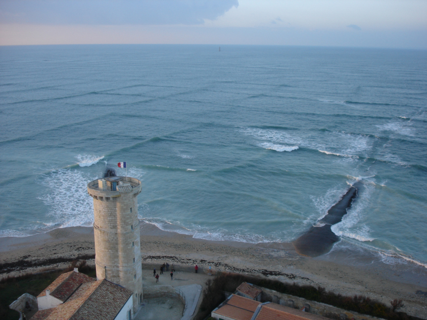
Ile de Re cross-current – Photo by Michel Griffon
Shock waves formed a similar effect, only carrying electric current. As the layers of the dome built the Colorado Plateau, they scarred the land with these patterns.
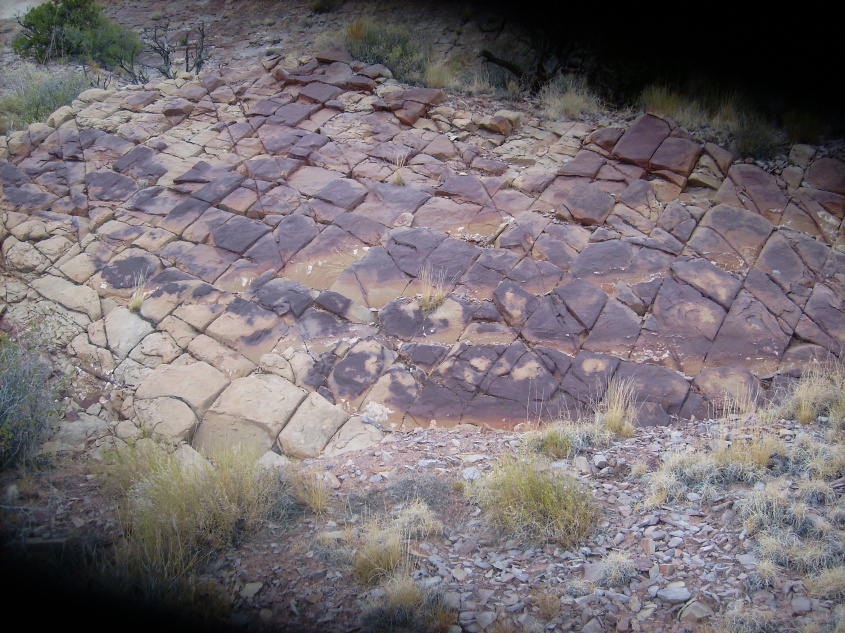
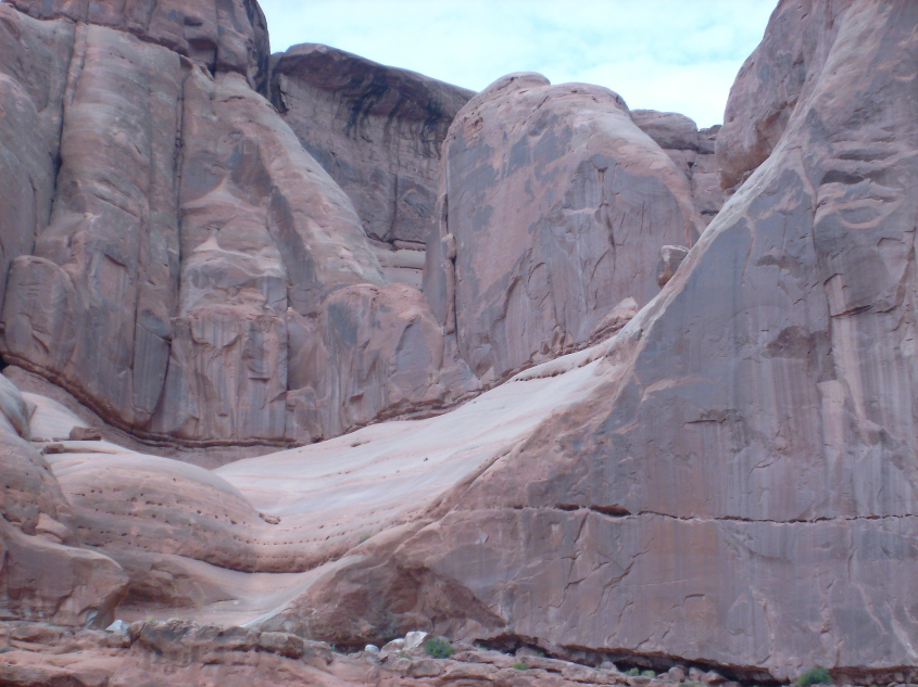
Harmonic reflected shock wave patterns in Utah. Angles at 90 and 45 degrees.
This shock wave fracture pattern is almost universally found in the rim rock and cap rock of sputtered canyon walls, buttes and pinnacles. The fracturing takes the form of parallel joints, or checkerboard blocks. The blocks are sometimes deeply cut and look like broken teeth.
Electro-sonic shock cuts deeply in monolithic layers.
In other cases, they are straight, evenly spaced, parallel fissures. Razor thin shock waves created the fractures in the cap and rim rock as the dome was deposited, while it was still hot and plastic. Thermal contraction during cooling, and the tearing away of material during sputtering, broke the rocks along the shock induced fracture lines.
When nature uses a ruler – think electro-sonic shock.
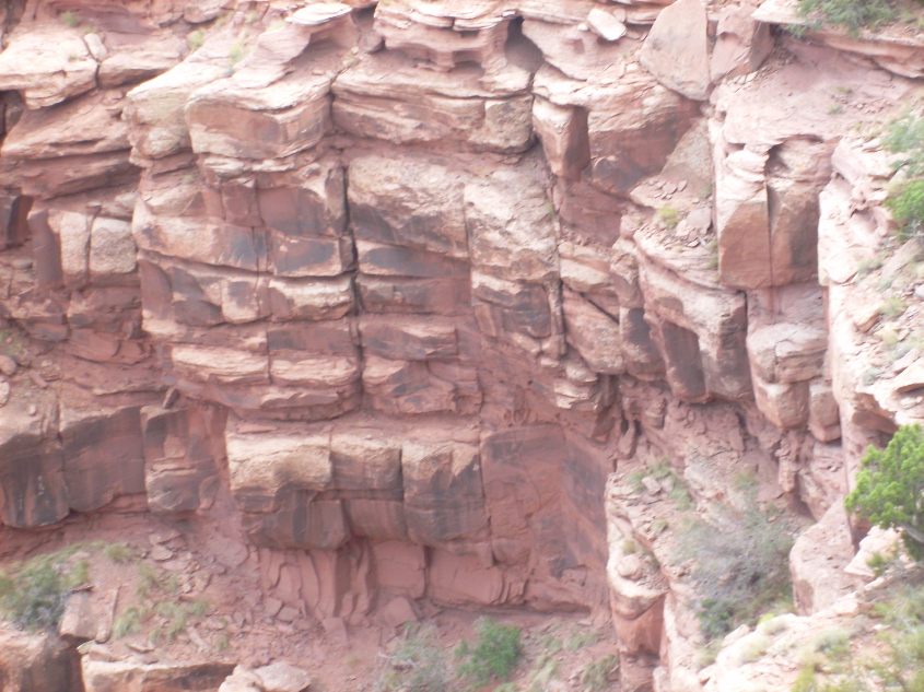
Shock patterns change between layers deposited by successive winds that cause discontinuity in fissures.
Shock patterns capped by a layer of un-shocked sandstone.
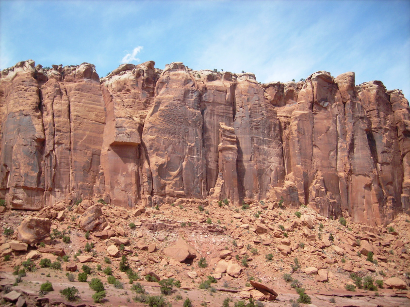
The same effect is seen in completely different geologic formations – the windblown buttresses on mountain flanks. These images are from Comb Ridge, which is the southern rim of the Monument Valley dome, and San Rafael Reef at the southern rim of the San Rafael Swell. Both are dunes of triangular buttresses formed by the supersonic winds sucked into the storm that formed the domes. The shock waves from the supersonic winds that formed the dunes impressed themselves into the rock.
Comb Ridge checkerboard shock patterns.
Triangular flat-iron buttress in Comb Ridge with checkerboard shock pattern.
Flat-iron buttresses San Rafael Swell, Utah. Note shock patterns on two successive layers, upper left and foreground.
The shock wave currents shatter into harmonic reflections in ever smaller patterns. In formations where extremely high energy was available, such as the hardened plates of flat iron buttresses on the San Rafael Reef, the shock waves continued to shatter, reflect and reverberate down to the smallest scale.
This rock photographed from a flat iron buttress in Utah by Robert Hawthorne, during a field trip following the 2017 conference, shows parallel cuts in rock only a half inch apart.
This rock photographed by the author from another buttress in Utah during the 2016 field trip. It shows the squiggled fractures of a dissipating, shock induced current along the back edge of the buttress. These rilles only penetrate a fraction of an inch into the rock, and really defy any other explanation, unless rock eating worms cut these paths.
Another feature related to shock induced currents in linear, parallel formations, are something we’ll call, inverse dykes. A dyke is a vertical wall of rock. It can be free standing, or it can be embedded in a parent rock, like a quartz vein in granite. Quartz veins are caused by very high-current shock waves (which immediately raises the question, how does gold get in them thar veins? But that is a question for a future article.)
These dykes are made of minette, which is very high in potassium ratio, making the rock highly alkaline, or anionic. Which means it’s electrons were sucked out.
Minette dyke projects from Comb Ridge in background.
Minette dyke undulates across plains south of Comb Ridge.
They were made by shock wave currents – electro-sonic waves that scored across the land and fused the parent sands into walls of electro-chemically altered rock. They emanate from Comb Ridge on the south side of Monument Valley. And they are coherent with the triangular flat-iron buttresses of the Comb, which were formed by the same shock waves.
Blue lines trace minette dykes from Comb Ridge
The black dykes align with the Mach angle of the shock wave that formed the Comb’s flat irons.
Inverse dykes are similar wall-like features that were formed by currents that depleted the rock, shielding it from sputter. These upended pancake walls at Arches N.M., Utah were left standing as the lanes between them sputtered away, in the same fashion that preferential sputtering left mesas and pinnacles in the shadow of lightning strikes. Only for these, the diffusion of charge depletion was shaped by electro-sonic shock waves.
You can see they are layered, like the deposition layers of the mesas. Dykes don’t have deposition layers – they actually cut through deposition layers. Inverse dykes have deposition layers because they were part of the dome before it sputtered.
Inverse dykes of deposition layers undulate through sputtered canyons in Arches N.M.
Another phenomena related to the whole sputtering process is gaseous explosions. It primarily occurs during dome deposition, when hot sand rains down, accelerated by the electric field under the eye-wall of the storm, to be pressed into a layer on the dome.
After deposition, but while the rock is still hot and plastic, still popping and sizzling with excess charge, volatile mixtures accumulate in pockets. The pockets migrate through weak joints, dykes and veins in the rock, to explode near the surface, leaving holes from bubble bursts. Remember, the veins and joints are current carrying, shock induced features, so they dissipate heat and current as they cool.
Each hole can be associated with a fissure, or seam in the rock.
Tiny bubbles erupted along a fracture line, bottom left and center right.
Hand sized bubble bursts.
It’s very similar to the heat spiking bubbles that created Arches, N.M., but this occurs during dome deposition, not sputter. The gases are aided, or caused, by residual current in the rock escaping after it deposited.
It can leave perfect bubble imprints in dense, hardened rock. Look carefully at the bubble imprint lower left of the arch. It has a “Y” shaped ridge that is the precise symmetric pattern molded into the rock that three bubbles connected would present, because they have to equalize pressure across their membranes. This is not water erosion. This is bubble explosion.
Look for the Y-shaped star in the lower left-most bubble impression.
Interesting flash-over patterns in the broken rock face near the hole causes patina of ‘desert varnish’. Looks more like drool from the lip of the bubble burst.
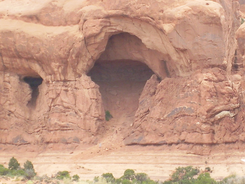
They also explode outward in large jets, off-gassing the hot fresh mountain as it settled and cooled, leaving ‘yawning throats’ like this.
Blehhh … Pardon me!
The light at another time of day on the same ‘yawning throat’ in the San Rafael Reef, Utah shows the band of white crystalline dyke that the gasses migrated through. The ‘tonsils’ are a blade of the rock dyke.

A gas jet blew out along a dyke, which forms the cleft in the roof of the cavern.
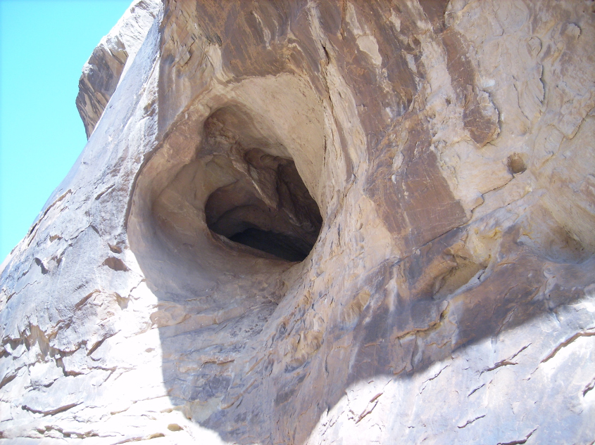
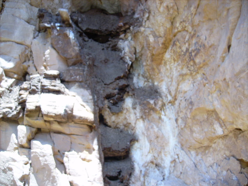
This slot canyon in the San Rafael Reef was cut by a discharge of current and off-gassing. The discharge was powerful enough to cut the narrow canyon, implying it was an arc mode discharge.
Looking out the slot canyon.
The throat of the discharge is a hole about 3 feet in diameter. It is choked with an effluvia that followed the discharge and solidified as it dripped from the throat. There is a vertical dyke in the rock aligned with the hole, which can be seen as the white streak in the vee-notch above the hole.
Looking into the slot canyon to throat of discharge.
The throat is completely choked with the effluvia. The effluvia is black and textured much like minette, found in lightning generated features elsewhere in the region.

Throat of the discharge that cut the slot canyon plugged with solidified effluvia.
A runnel of the black effluvia drips from the throat, and the walls near the throat are splattered with a white substance.
The throat is plugged with solidified
Taste testing the white substance indicated an alkaline bitterness. Being in a National Park, samples could not be taken, so no further analysis is available.
Curious research assistant sniff tested and reported a ruff scent.
Off-gassing bubbles can be quite elaborate in volatile flows of foaming minerals. This carbonate rock fizzed like seltzer before it suddenly phase-changed to solid leaving exquisite bubble molds. Such sudden phase change implies an instantaneous electro-chemical process due to electrical discharge and recombination.
This image shows why off-gassing bubbles are part of deposition, not sputtering. The bubbles are in the untouched surface rock above, while the scalloped break in the rock (from a cupping spall caused by sputtering) has no holes. The holes were already there when the canyon was sputtered, and are only a near surface feature caused by off-gassing.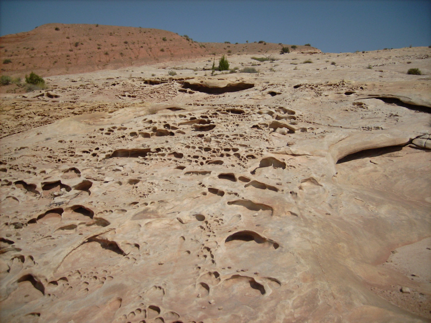
Bubble holes in native rock above spalled section occurred at deposition.
While theory and conclusions presented here are the sole opinion of the author, appreciation to the researchers who spent hot, grimy hours exploring Canyonlands to obtain photos and data is due. Researchers Larry White, Bruce Leybourne, David Orr Steve Cash and Ginger endured extreme heat, dangerous roads, treacherous heights and fine sand in their food, examining the wonders of Canyonlands, Utah for this article.
Thank you.
Quick Tip
Please help support The Daily Plasma.
Also published at Thunderbolts.info
In Part 1 of Sputtering Canyons, we discussed Arches National Monument, and evidence it was formed by a complex sputtering discharge process. That process involved a thermal spiking, barrier discharge in a layer of wet sandstone.
In Part 2, we’ll take a broader look at some regions on the Colorado Plateau where similar sputtering discharge processes took place.
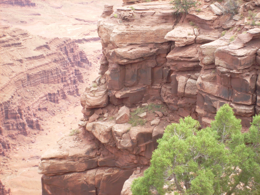
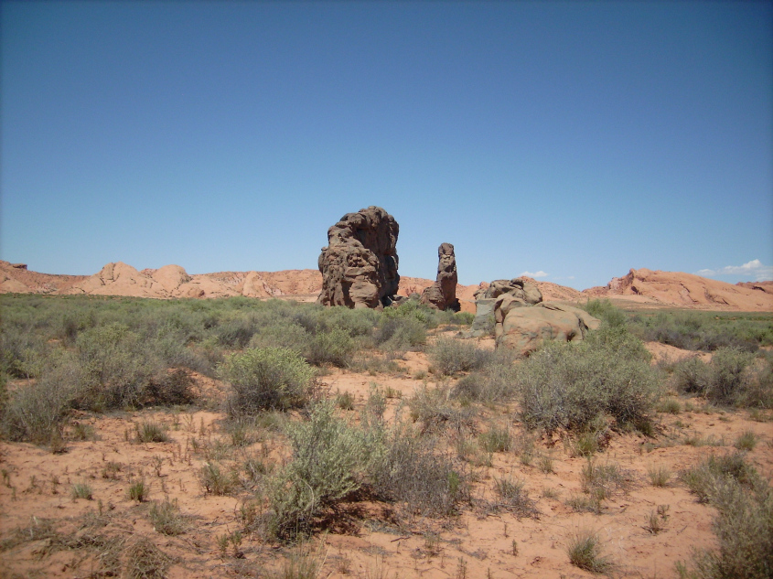
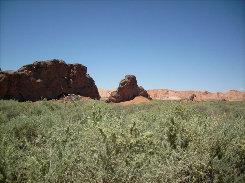
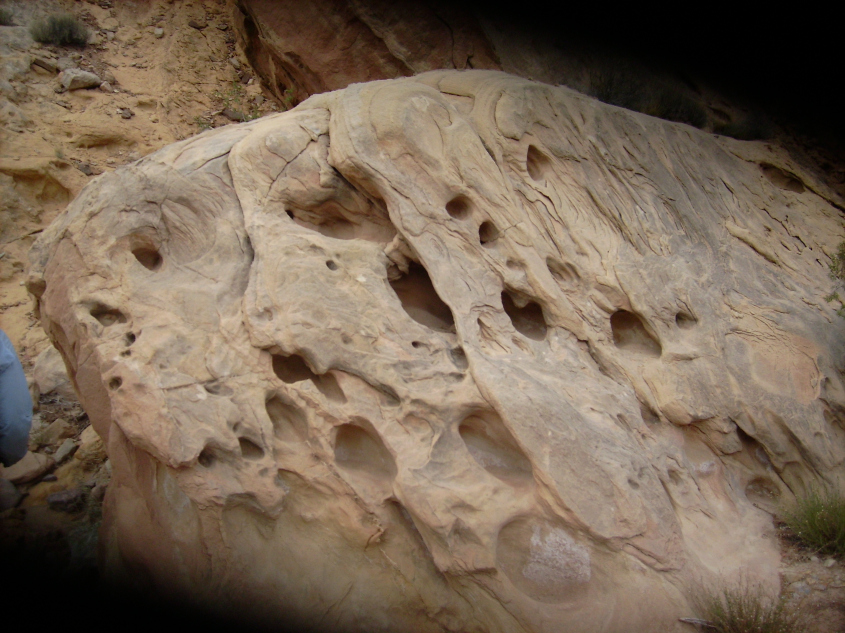
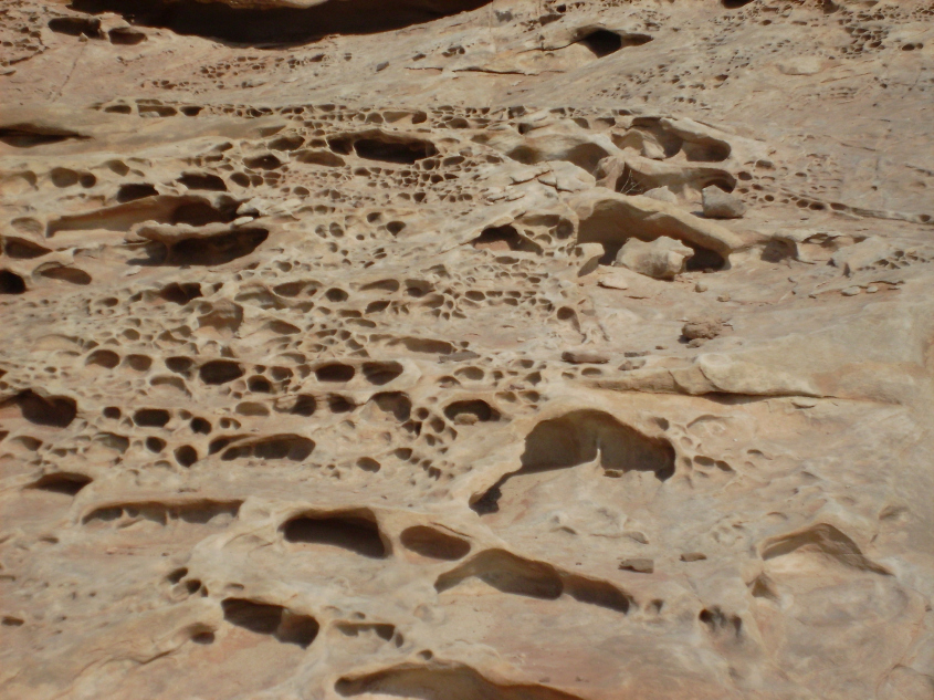
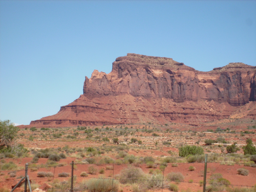
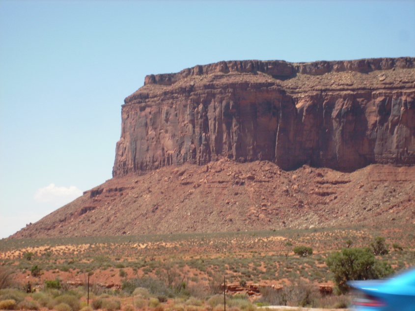
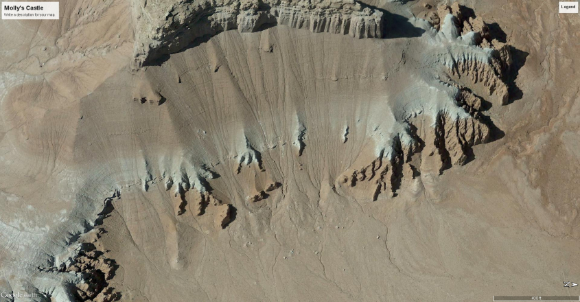
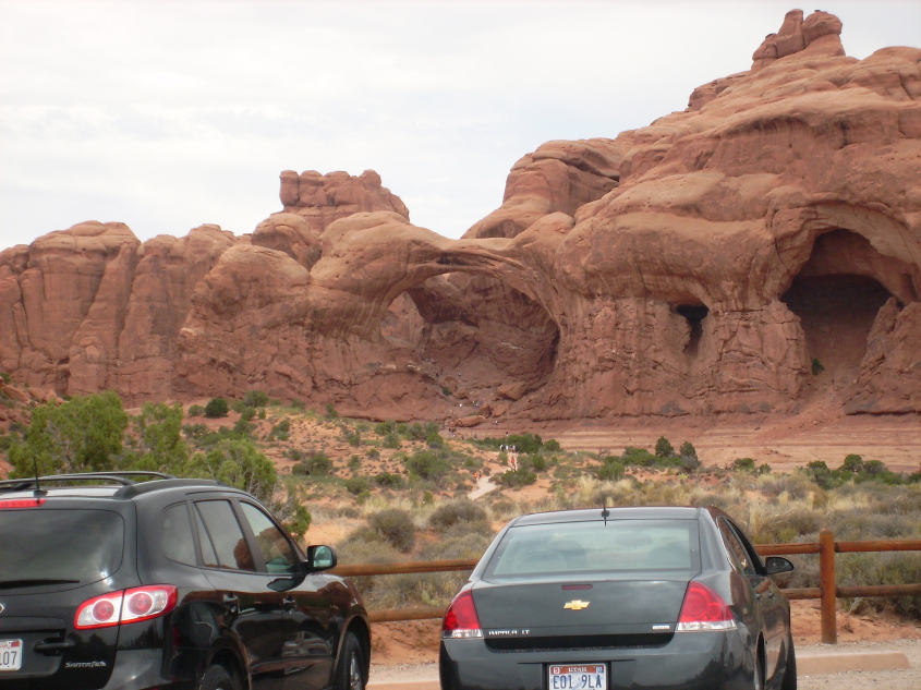
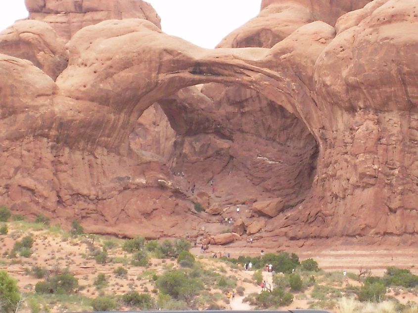
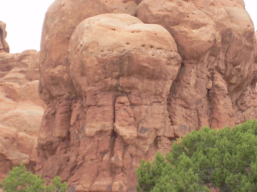
One of these is Monument Valley. Monument Valley was formed by sputtering discharge that almost completely etched a layer of the original dome away. What is left are the lonely pinnacles and buttes iconic to Western movies.
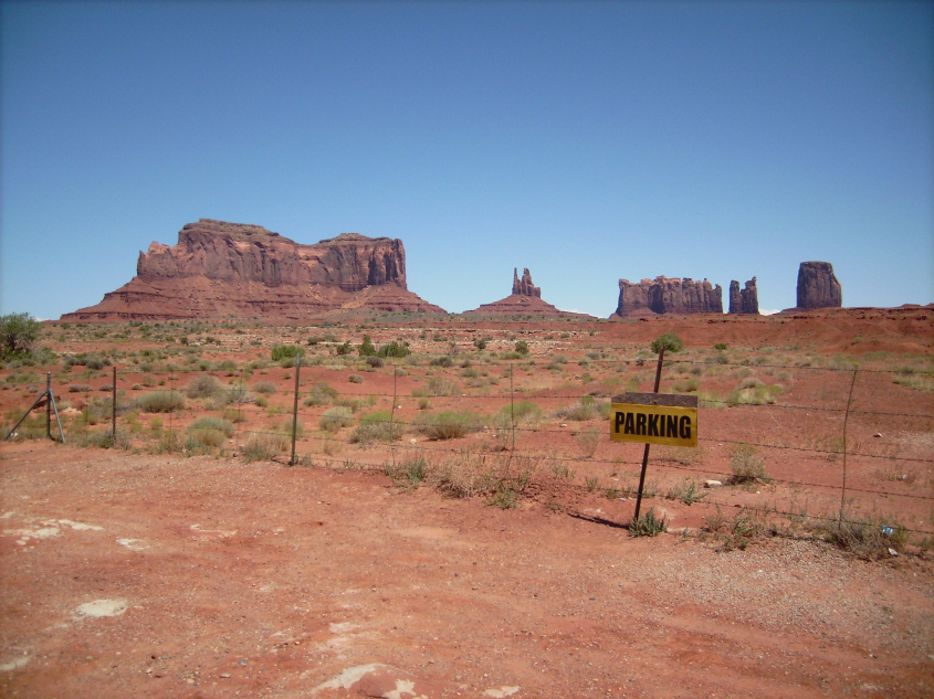
Monument Valley, Arizona
The reason these pinnacles and buttes are left standing, while the same layers of sandstone etched away around them, is due to preferential sputtering. Preferential sputtering is normally associated with sputtering an alloyed metal where one element in the alloy sputters more efficiently, eroding away faster than the other alloy metal.
In Monument Valley, the buttes and pinnacles left standing were portions of the dome that resisted sputtering because of a difference in charge density. The part of the dome that lifted away, did so when the wet layer – the icing in the layer cake – became a charged, hot ionized mud. A sheet of high charge density developed at the base of the mud with an attraction to the clouds above – and like an electromagnet picks up a junk car – the storm’s electric field lifted away the overburden to dissolve in electric winds.
The buttes and pinnacles are remnants that didn’t have the same charge in their wet layer, so they didn’t get pulled away by the electric field. The reason is: they were struck by lightning.
In the dark mode, drifting plasma current that causes sputtering, there is always the potential to spark. Manufacturers are careful to avoid this because it will flaw the finished surface. The pinnacles and buttes were parts of the dome where an arc, or many arcs struck and dissipated built-up charge. Instead, it altered the ground charge beneath the strike zone so the electric field couldn’t pull it away. Therefore, the buttes and pinnacles were preferentially – not sputtered.
In the parlance of the semiconductor industry, the charged layer was doped by the presence of water and minerals, which gave it an excess of electrons. When lightning struck, it depleted the charge and left an excess of “holes”, or the absence of electrons, which cancelled the attractive force of the sputtering discharge.
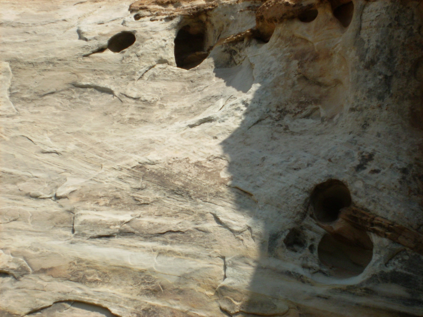
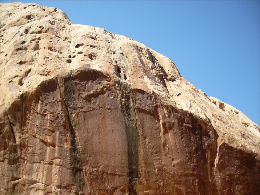
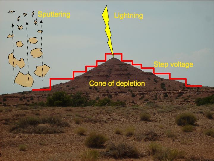
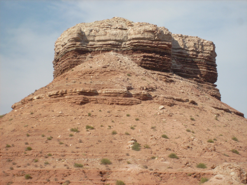
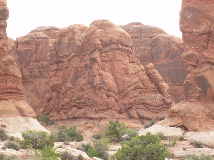
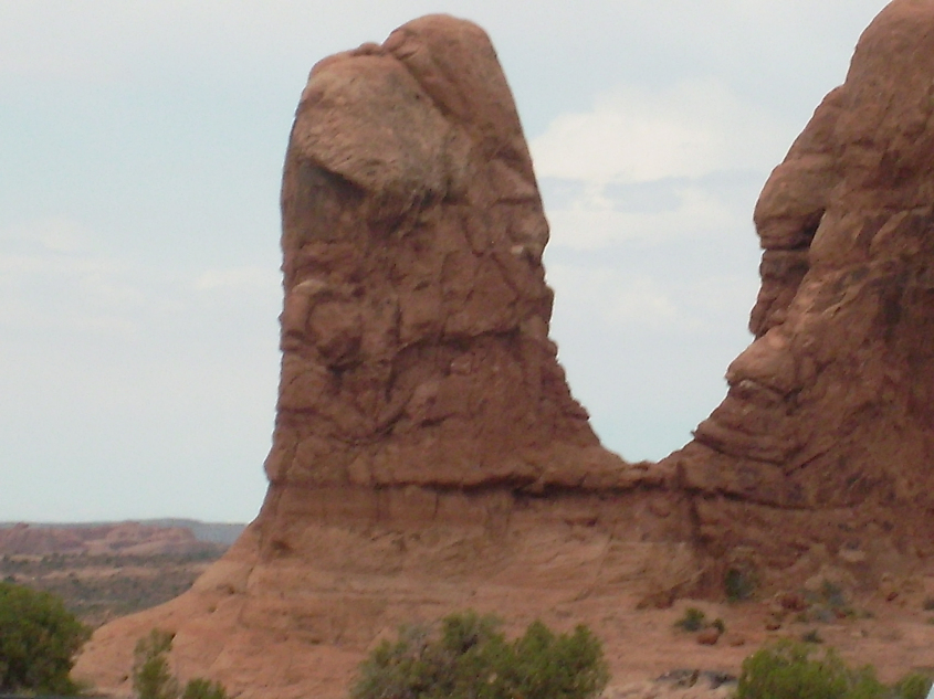
The evidence for this is manifold. To begin, consider the cap rock formations and spires found on buttes. Butte tops aren’t flat. They generally have something like a step pyramid, dome, or pinnacle on top, which is where lightning discharge was most intense.
Notice, in the images below, the pyramidal caps. The rock below the caps is darkened significantly more than adjacent stone. Not only is there black patina, but there is also more redness to the rock itself in streaks below the caps, with deep vertical fracturing. The charge depletion from lightning, and the subsequent recombination of the most severely depleted zones beneath where it struck, heated, shocked and hardened the rock more in these areas than in others.
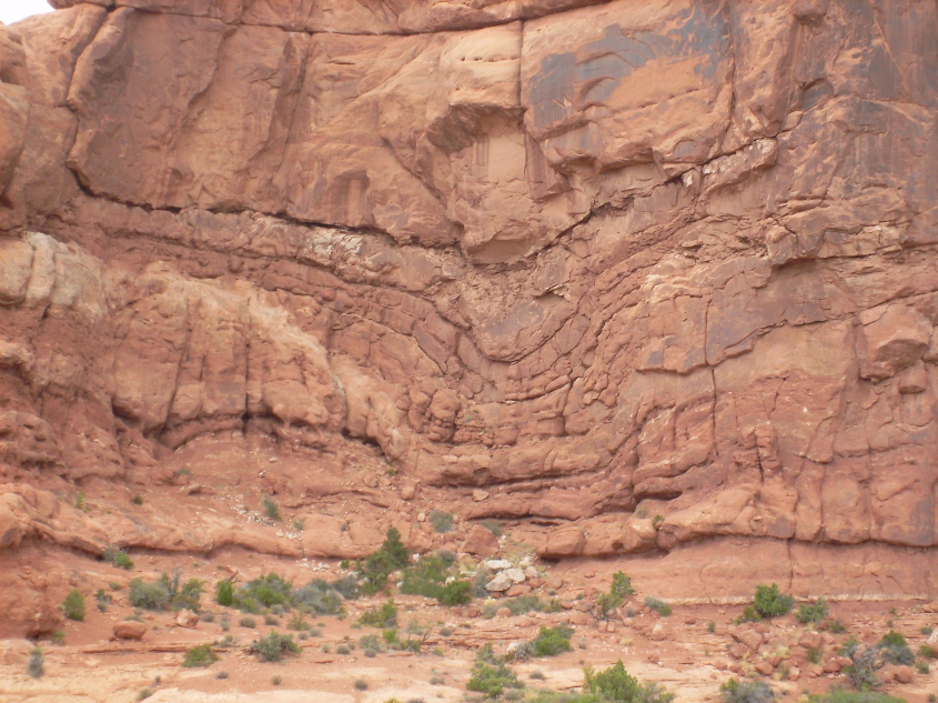
The step pyramid structure, or terracing on canyon walls and buttes is another evidence of sputtering. Each sedimentary layer has different compositions of minerals and moisture, differentiating the dielectric property of each layer. The zone of charge depletion under lightning strikes spreads out in a conical diffusion pattern, but the cone is stepped, or terraced, because there is a step voltage across each dielectric layer. Where there are towering cliffs with sheer vertical walls, it is because it is a monolithic layer with a consistent dielectric, causing a single large voltage step.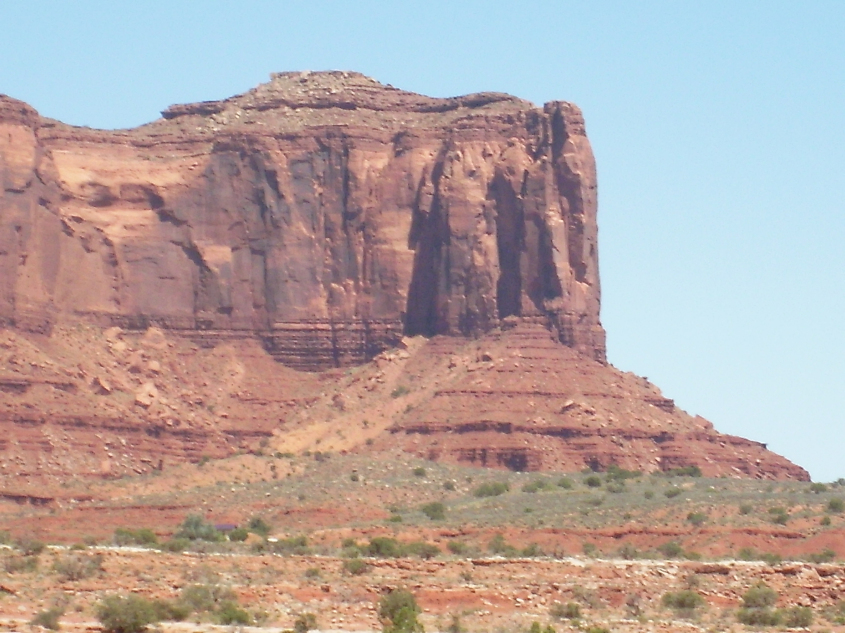
Where there is very hard rock, the edges are torn in chunky blocks. The flat, smooth breaks are not the result of millions of years of erosion of any type – wind, rain, ice, exfoliation, or flowing water. Any of those actions would have the opposite effect. The rocks have such smooth, flat faces, and sharp, angular, undercut edges because they were broken by mechanical shearing as the neighboring rock was ripped away.
Evidence of shearing is especially evident on monolithic walls. Sharp edged breaks are everywhere, leaving smooth, flat faces, hardly roughened, or rounded by any act of erosion.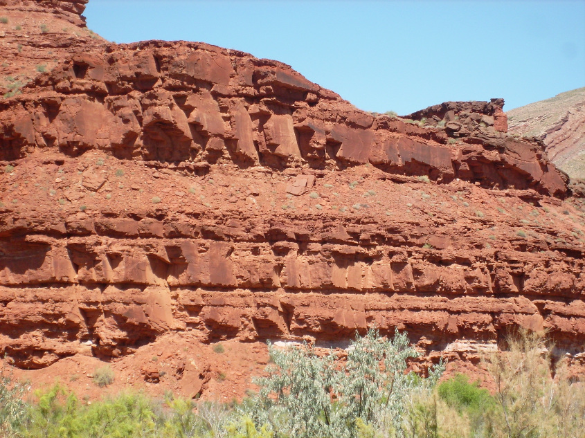
Arching fissures are evidence of spalling, where the material tore away in flakes, cupped upward in the direction of shear. The arches often show concentric creases where flakes broke away in smaller sections deeper into the rock. One can see the same type of concentric flaking in broken glass.
In some places the canyon walls have the look of broken glass. In others it looks more like the broken end of a brick of hard cheese. Perhaps a well-aged Parmesan – stiff, dry and flaky, with a low shear strength.
Upward cupping flakes leave spall marks from shear.
Cupping spalls where rock flaked during shear.
Cupping Spalls
Cup shaped spallation
Cupped spallation with effluvia spilled from a fissure.
Big cupping spall inside a spall.
Besides cupping spalls, some surfaces show other evidence of stress fracturing due to shearing force.
Stress fractures create sharp edged, wavy spalls where rock was torqued as it sheared away.
There is almost always a thin layer of hardened rock at the interface of each terrace. This is where charge accumulated at the boundary layer of the strata, and the current hardened the charged sheet of rock more so than the surroundings.
Each dielectric layer spreads charge to the interface of its layer, driven by the electric field, to balance the voltage drop across the layer. So a charged sheet develops at the interface of each layer, and a step voltage to the next layer, which creates a surface tension at the interface, which makes the rock hard and dense. What is sandwiched between is often loosely consolidated.
Pinnacles in this region are of two types. Fulgarites, like the burnt shard of Agathla peak, are the direct result of lightning boiling up the crust of the earth in an electromagnetic blister. These types of pinnacles were discussed in Lightning Scarred Earth, Parts 1 and 2 .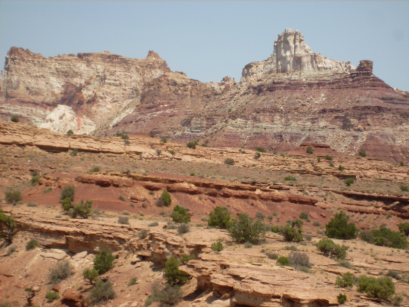
Agathla Peak in Monument Valley is a lightning blister.
Sandstone pinnacles are where lightning struck and altered the charge in the rock beneath it, creating an electrical ‘shadow’ to sputtering discharge. They are literally, the shadow of lightning strikes.
The footprint of a ‘brief’ strike, comparatively speaking, produces a narrow cone of protection. How the cone slopes and steps depends on properties of the rock layers and the electric field potential.
More sustained, or potent striking begins to diffuse charge depletion outward, forming nodes, or star like breakouts. Still larger accumulation of strikes, diffuses charge further, and nodules break out into ‘wings’, or dykes of charge depleted rock. The shadow footprint grows as arcing continues, elongating charge depleted zones into wedges with dykes growing out the tips and edges. It’s actually the beginning of a fractal dendrite, as lightning bombardment soaks charge from the ground, diffusing outward in branches and creating a depleted zone protected from sputtering. If the process continued before the surroundings sputtered away, the dendrite nodules would grow and branch in ever smaller fractal repetitions, like branches of a tree. As adjacent rock is struck, the depleted zones connect into networks of wedges, ridges and pinnacles. Generally, the pinnacles and buttes left on a dome are layered flat, but in some areas buttes display a dip, indicating horizontal winds influenced the deposition. Sputtering follows the voltage gradient, and so carves away from the lightning depleted zone in alignment with the strata because the voltage gradient follows the dielectric layers, cutting at 90º to the dip angle, leaving a straight-edged non-vertical wall. If eroded by conventional notions of wind, rain and mass wasting, the rock would obey gravity and erode a vertical wall. It is in details like this that prove electrical formation. What we see in the stepped pyramids and terraced canyons is the result of two types of charge transport in a solid state matter. One is drift ionization caused by the external electric field of the storm, and the other is diffusion current caused by differences in charge density within the material of the dome.
Drift current is the flow of charge created by the external electric field of the storm, which primarily drives the ionized region downward, vertically through the layers of sandstone. Drift currents obey Ohm’s Law.
Diffusion current obeys Fick’s Law, which is related to Ohm’s Law, but accounts for variations in charge density that causes ionization to migrate from a region of high charge concentration, to a region of low concentration. No external electric field is needed for diffusion current, because the difference in charge concentrations creates a gradient between regions that results in a local electric field. This is the primary process that migrates charge horizontally – spreading out through each layer of sandstone.
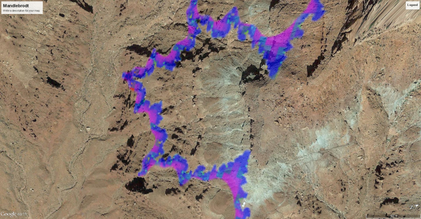
What is carved away by sputtering leaves distinct scalloped edges in very dry, low conductivity material. The scalloping is a fractal phenomena of electrical diffusion that repeats the scallop shape in ever larger scallops.
Canyon rims are dry, course, and broken, with scalloped walls.
There is very little fallen, broken rock surrounding buttes and pinnacles.
In wetter environments this isn’t as apparent, or it may be totally absent, because water diffuses charge more evenly, creating smoother surfaces.
Compelling evidence the scalloped and terraced walls are a result of charge diffusion is shown in this image, where the archetype of all fractal shapes emerges – the Mandlebrodt Set.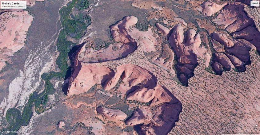
Although it’s not a computer perfect rendition of the Mandlebrodt Set, it is nearly so. It’s a naturally generated fractal based on the same mathematical relationships of iterating three dimensional motion that governs electrical charge diffusion in solid state electronics.
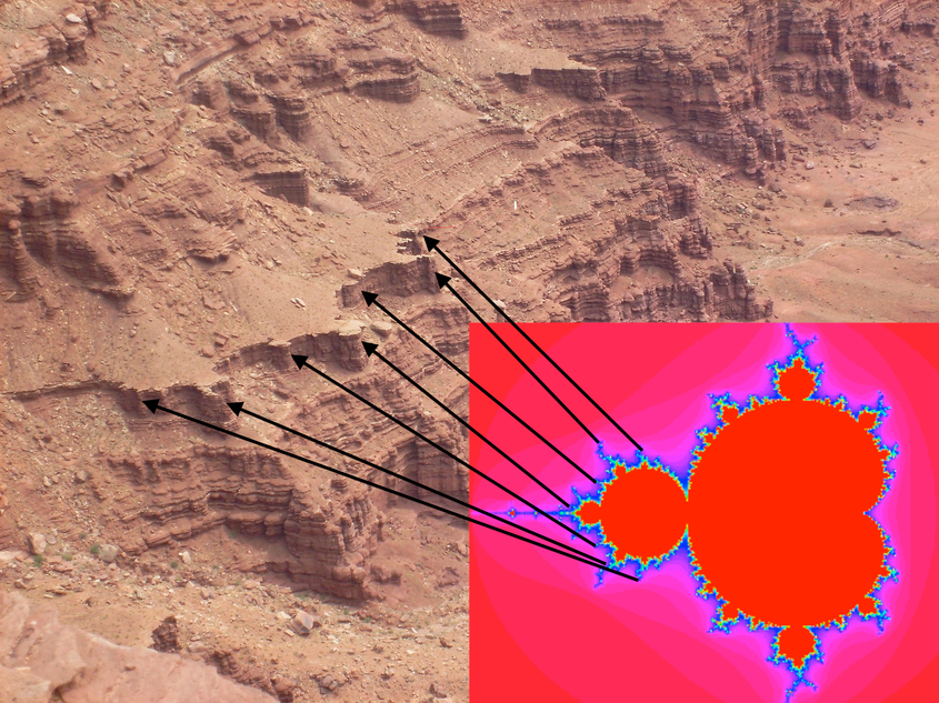
The implication is obvious. The shape of the canyon walls, the terracing, the fractal repetition of form – everything known about applied physics dictates this is the result of electrical current diffusion on a continent-scale semiconductor under the influence of a gigantic electric field. The physics is not only laboratory proven, it’s been used to make every semiconductor device ever manufactured.
In fact, geophysicists and even Hollywood CGI artists, simulate geologic forms like watersheds and river systems, canyons and mountains, using the fractal geometry of electrical diffusion. So, what is being described here has been acknowledged by consensus science. The scientific conclusion that these land forms are the result of electrical diffusion caused by an intense electric field influencing Earth’s crust, in an event in the manner Electric Universe theorists have described since Immanuel Velikovsky, is scientifically unavoidable.
Yet avoid it they do – consensus science, that is. To quote from a Wikipedia article on diffusion:
“Analytical and numerical models that solve the diffusion equation for different initial and boundary conditions have been popular for studying a wide variety of changes to the Earth’s surface. Diffusion has been used extensively in erosion studies of hill slope retreat, bluff erosion, fault scarp degradation, wave-cut terrace/shoreline retreat, alluvial channel incision, coastal shelf retreat, and delta pro-gradation. Although the Earth’s surface is not literally diffusing in many of these cases, the process of diffusion effectively mimics the holistic changes that occur over decades to millennia.”
Do you see what is going on here? Geophysics uses diffusion models to recreate Nature’s landscapes – they use the mathematics and physics of charge diffusion to do it, but don’t understand why – they think it’s just a coincidence. Rather than conclude from empirical data they have in hand, in proper scientific fashion, that electric current diffusion has a role in shaping the landscape, they conclude it’s just coincidence.
One hates to be critical of hard working geophysicists, but to have an empirically proven answer staring you in the face – and even be using it, with great success, as your model – and still ignore it in favor of a preferred narrative, is what a politician does, not a scientist. The idea that diffusion “mimics the holistic changes that occur over decades to millennia” is nothing less than absurd.
Diffusion is caused by charge transport from higher to lower concentrations. It’s an inside-out physical phenomena. It occurs at the atomic level, where charge diffuses from atom-to-atom, and then works its way out with secondary effects to produce the macro-fractal patterns we can see. Conventional erosive forces of water, wind and ice act on the land from the outside in, not from the inside out. They can’t possibly produce the kind of landscapes we actually see, and that is why they cannot be modeled with hydrodynamics, or any of the unverifiable effects of slow random forces of wind, ice and water acting over millions of years.
Scientists are forced to use electrical diffusion to model the obviously fractal and non-random forms on the landscape because it’s the only model that works, yet are so invested in scientific dogma they can’t see the discovery they made. It verifies everything I’ve said, so I appreciate they’ve already proven my case. But their notions violate physics, which is something they obviously don’t understand, so they call it a coincidence instead.
Fortunately, in EU we like to deal in truths. In Part 3, we’ll examine a few more examples of Sputtering Canyon evidence.
Please, Like and Share this post:
Filed under: Electric Earth, Electric Universe, geology
![]()
[
Sputtering Canyons, Part 1
](Sputtering Canyons, Part 1 – The Daily Plasma)
Also published at Thunderbolts.info
In summer of 2016, following the EU Conference in Phoenix, Arizona, EU Geology researchers visited Arches National Monument, and the deep reaches of Canyonlands, Utah, where the Green and Colorado Rivers channel through the Colorado Plateau.
Arches National Monument is an astonishing place for anyone interested in EU Geology. By conventional reckoning, the high desert plateau was carved into fantastical arches and hoodoos after millions of years of subtle water and wind erosion. To the EU researchers, however, it was evident the land was zapped, carved and seared by electrical storms that could have happened last year, so fresh looked the marks of evidence.
The Arches’ formation tells a story which explains one of the key phenomena that shaped the face of the planet. The phenomena is called sputtering discharge. So let’s take a look at what that is.
Arches National Monument, Utah
Sputtering discharge, as used in manufacturing, is a dark, to glow-mode current in plasma used to deposit thin films of material onto a substrate surface. It’s analogous to electroplating, or galvanic reaction in a fluid.
An electric field accelerates positive ions in plasma to collide with a source material, which breaks molecular bonds, eroding the source material. This is what the term “sputter” refers to – the breaking away of particles which then drift in an electric field to coat the substrate. The source material is the cathode, and the substrate is the anode in the circuit. The material exchange is performed by electricity. Manufacturers often use magnetrons to shape and control the current, and improve material transport efficiency with external magnetic fields.
The point to be made, however, is that high voltage, low current in a plasma will erode, or etch away a cathodic surface and plate itself in layers on the anode. This is the process that shaped Canyonlands.
To fully understand these canyons, however, we must first understand domes, because the canyons are carved from a dome. The entire Colorado Plateau is a dome – or rather, a series of domes overlaying each other. The domes are composed of sedimentary layers of limestone and sandstone. The layers are stacked for the most part evenly and flat, like a layer cake.
This basic layer cake structure is capped with the Rocky Mountains on the East and carved into canyons on the West, while shot through with the Lichtenberg patterned, vertically cut gorges of the Colorado and Green Rivers.
The dome structure of the plateau, and the canyons carved through it, is primarily the result of a natural sputtering discharge process created during intense electrical storms. Of course, in this case, we are speaking about storms created in a past environment, when Earth’s electric field was amplified to the point the atmosphere ionized.
Imagine the atmosphere stirred into a maelstrom lit with streamers of glowing plasma. Where lightning crackled, not only in the sky, but across the land, and mountain tops glowed with coronal fire under swirling clouds of dusty plasma.
It would have been surreal. A place where streams of wind became electric currents. Where high and low pressure zones acted like battery terminals, and mountain tops became electrodes drawing machine gun lightning from the sky. Anything standing in the wind would have hissed and snapped with coronal fire.
Dust in the air would have acted strange, too, as the energy of free electrons collided and overpowered weaker atomic bonds, ionizing matter, causing it to act like a ferro-fluid under the influence of a magnet. Ionic species segregated, forming unipolar winds that tore past each other in opposite directions, creating shear zones of intense electrical discharge, and vortex winds of supersonic speed.
The inside of Earth would have been in turmoil as well. Hot magmas spewing from volcanic vents. Aquifers boiling. Explosive eruptions of steam from deep underground, pocking the landscape with holes. Even arcs would erupt – lightning from the ground – caused by buried pockets of charge where minerals and water ionized.
The winds, dust laden and electric, deposited the Colorado Plateau, plating a cake across the western half of North America in the same way semiconductor manufacturers layer circuitry onto silica wafers. The stratified layers are interspersed with magma flows, petrified forests, inland seas and dinosaur bone-yards of different ages that indicate it formed in a series of events that likely recurred over millions of years.
To create the Canyondlands, the voltage potential had to reverse, and eat away at landscape newly laid down by the storm. Under the electric field of an electrical storm, the surface of the earth becomes positively charged. It becomes the anode in the circuit where lightning strikes from the negative cloud base, and where rain falls. In primordial ionic storms like those that formed the plateau, rain didn’t fall, but silica did, as dust in the air fell and adhered in layers to the dome.
Inland seas, or layers washed over by tsunami generated by the storm itself, became covered over with more layers of dry overburden as the storm progressed. This left a moist layer, like icing in the center of the layer cake. This icing layer then ionized under intense bombardment from sputtering discharge in the eye of the storm, and created what is known as a barrier discharge in the moist layer beneath the ground.
Which brings us to Arches National Monument, proof that the canyons were carved by sputtering discharge, aided by barrier discharge, in a moist layer of the big cake.
This image tells most of the story. A band of rock that looks tortured and fluid, as if it were boiled mud when it solidified, sandwiched between smooth, more-or-less even layers of stone. The canyon floor is flat, which is surprising, if one accepts the consensus view that the canyons were made by water erosion. Water erosion leaves deep channels and vee-cut valleys, not flat floors.
‘Boiled Mud’ layer in Arches National Monument. The undulating bottom of the ‘boiled mud’, strata may be indication of tufting typical in plasma discharge.
This closer image (below) shows the fluidity of the layers. The overburden rock barely sinks into the sagging layer that turned plastic beneath it, because it was still solid. The plastic layer sagged, but didn’t compress, maintaining a consistent thickness. But on the bottom, the ‘boiled mud’ layer fluidized and squeezed like toothpaste.
What turned this layer fluid, and caused it to sag beneath a solid overburden, was electrical current. A barrier discharge current, where no gaseous atmosphere was present to ionize into plasma, but instead, the moisture and mineral in the layer ionized, generating a subsurface current.
Fluidity in the ‘boiled mud’ layer.
The moist layer ionized and charged species pooled into a plasma-like mud the electric field wanted to lift away. The electric currents boiled the moist layer and it began to foam and arc into the drier and electrically resistant overburden. When sputtering removed the surrounding overburden, pressure released and vapors expanded, making gas bubbles that raised the arches. Hardened pinnacles formed where mud boiled up in convective blossoms of hot ionization.
The arches rise from the ‘boiled mud’ layer.
Bulbous nodules rise from the ‘boiled mud’ layer like bubbles of foam.
Beneath the ‘boiled mud’ layer, strata returns to evenly structured layers.
A yawning arch rising from ‘boiled mud’ due to gas bubbles. The small hole to left is flattened against the hard overburden, as a bubble would, pressing up against a barrier.
One can see how the moist layer boiled and heaved, while currents arched and thrust upward, trying to break through the overburden rock. But in this area, it was unsuccessful. The traces of barrier discharge remain in the rock. The empty, flat canyon floor, where the overburden and moist layer were carried away is where the discharge broke through to complete the circuit.
Arches is a display of etching, or Electric Discharge Machining (EDM) stopped in process. The wet layer was boiling off due to the current in it, and lifting away with the overburden when the process stopped, leaving these arches and hoodoos. It likely stopped when the sputtering glow current suddenly jumped to arc mode, and lightning struck, dissipating the charge built-up in the wet, ‘boiled mud’ layer.
Sputtering discharge is typically used in manufacturing to remove only micro-meters of material. The ion bombardment on the surface of cathode material only shallowly penetrates to break atomic, or molecular bonds and release particles. So how could such a process remove hundreds of feet of solid sandstone?
One reason is the strength of the electric field at work on the charged species. In the primordial storm we are discussing, the electric field would have been many billions, perhaps trillions of volts. The electromotive force of such a field applied to any large pool of charged species could lift a mountain.
The other reason is diffusion of charge through a thousand feet of dry, sandstone overburden, to ionize the wet layer. The section of the dome overlaying the wet layer acted as a solid state semiconductor, coherent with the intense electric field. Charge diffused through the silica layers in a manner to be discussed in more detail in Part Two of this article.
The wet, ionized layer then underwent a process called heat spike sputtering. Heat spike sputtering occurs when diffusing ionization causes secondary reactions. The secondary reactions occur in the wet layer, which is highly conductive and volatile. Currents heated the material and caused thermal liquifaction, melting and steam micro-explosions.
In Canyonlands, the wet layer ionized, inducing currents which heat spiked, discharging from the wet layer to the layer above. The arches and bubble-like pinnacles in Arches N.M. were created by heat spike sputtering and bubbles from micro-explosions as the ‘boiled mud’ layer ionized, vaporized, and discharged into the overburden.
This short film produced by diveflyfish on YouTube helps visualize the process of diffusion through rock and barrier discharge that caused the ‘boiled mud’ layer to boil. In it, Jim Hamman, the creator of diveflyfish, and an EU contributor, employs a high voltage Tesla circuit to generate current through a granite block. There are two things to note as you watch the film.
First, note how the flow of electricity diffuses through the entire granite block. Instead of channeling directly below the electrode in a narrow stream, it flows out the full footprint of the crystalline granite block. The external electric field of the circuit is diffusing charge through the granite as in a solid-state body.
In the tense electric field surrounding the eye of the hyper-storm that etched the canyons, currents also diffused through the dome matrix in this way, ultimately ripping out mountains of earth in the blink of an eye as currents boiled and liquified the wet matrix below, similar to the plasma tornadoes swirling in the gaps between the electrodes and the granite.
Second, note the plasma tornadoes that bridge the gap between the block and electrode. They are not in bright arc mode, but are filaments in glow mode. The plasma tornado currents are in the air gap, where the air has ionized to plasma. In the Arches, there was no air gap between the ionizing wet layer and the overburden, so the discharge was a barrier discharge coming from the ‘boiled mud’ layer. The currents flowed around the boiling, bubbling, foaming heat spikes to fuse and harden the less conductive overburden in it’s pattern of arches and pinnacles.
Jim’s experiment was intended to look for piezoelectric amplification of the current, but isn’t instrumented to acquire a measurement in this video. It does however demonstrate diffusion of current through granite, which demonstrates how ground currents can diffuse in natural rock. Towards the end of the clip, arcing begins where hot spots begin to eat through the granite, collecting the current into a single path, and starving the diffusion currents.
There are many other evidences of sputtering discharge in the Utah Canyonlands. In part 2 of Sputtering Canyons, we’ll examine some more.
Thank you.
Please, Like and Share this post:
Filed under: Electric Earth, Electric Universe, geology
Space News Video January 13, 2018
[
Lightning Scarred Earth
](Lightning Scarred Earth – The Daily Plasma)
This two part video looks at lightning scars in the Four Corners region. Lightning is becoming recognized as the premier cause of mountain erosion, having far more impact than water, wind, ice, or exfoliation, at least on some mountains around the world. Lightning can blast a house size boulder apart, toss rocks the size of buses around and pepper the ground with pock marks.
In the past, lightning was far more severe, when Earth Earth was in a different Solar environment. Scars on the land attest to a time when the atmosphere heavily ionized, turning it to a plasma maelstrom where lightning strafed the landscape like a machine gun, and grew to proportions that created electromagnetic blisters on the land so large that we mistake them for volcanoes.
Quick Tip
Please help support The Daily Plasma.
[
Lightning Scarred Earth, Part 2
](Lightning Scarred Earth, Part 2 – The Daily Plasma)
Originally published by Thunderbolts.info
In Part 1 of Lightning Scarred Earth , Shiprock was presented as an example of a pinnacle created by lightning. Fulgarites are created when lightning strikes, and current penetrates the ground, leaving a hollow tube of glassy, fused material behind. Current from the lightning vaporizes and extracts material in it’s path, while it’s heat vitrifies the surrounding soil, leaving behind glassy tubes.
Based on it’s features, it’s proposed that Shiprock is a standing fulgarite, created by lightning so powerful and sustained that the material began to recombine in the current as it was pulled from the ground, leaving behind a pinnacle of fused material instead of a hollow tube. Once material recombines, it’s no longer charged and attracted to the lightning channel, so is left behind, it’s ionic makeup altered by the current and heat.
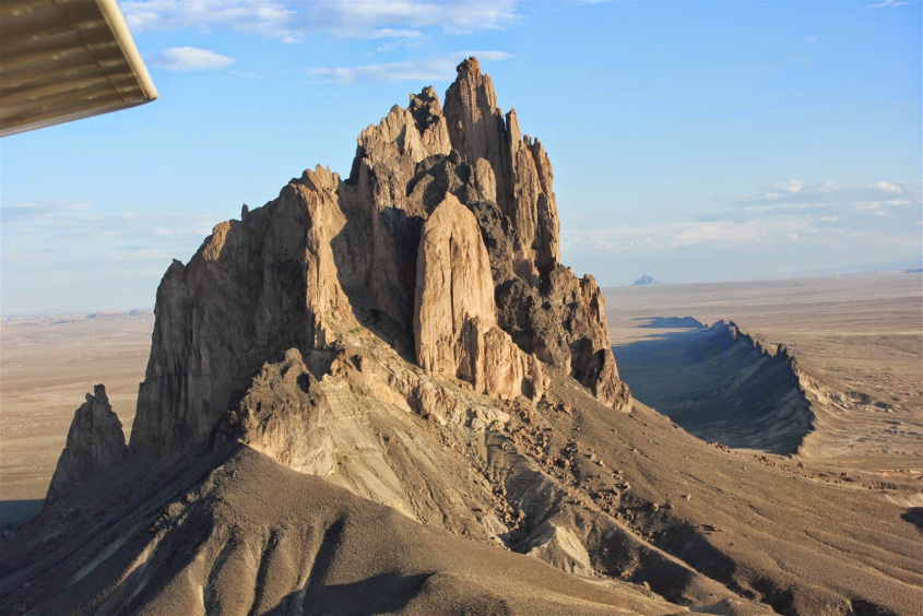
Dark minette spills from the center of Shiprock, surrounded by a broken sheath of lighter, distinctly different rock.
The morphology of Shiprock displays this very well, with columns of fused rock, surrounding an inner core of minette – ionically altered material pulled from the ground by the flow of current. Surrounding the pinnacle are minette dykes radiating away in a star pattern.
Dykes radiate from Shiprock in a star pattern
Minette is high in potassium and low in silica content. It contains high volumes of orthoclase and biotite. Both are minerals with high metal content, such as potassium, iron and sodium.
Silica dioxide will readily exchange oxygen with metals, such as those found in the orthoclase and biotite, when sufficient heat is applied. The prevalence of potassium and other metals crystallized in minette, and its under-saturation of silica, is evidence of the reduction taking place as it was formed.
This suggests that the lightning forming it was positive lightning, which is the type of powerful lightning seen striking from the stratospheric anvil clouds in thunderstorms. Electrons and negative ions in the ground, pulled out by the positively charged lightning, left behind a concentration of positively charged material which was not attracted and drawn away. The dykes and inner core of the pinnacle show the path of the current being drawn to the lightning discharge.
Delicate lichtenberg discharge surrounds Shiprock
Following the lightning strike that formed the pinnacle, the area was left with a net positive charge, which attracted a secondary ground discharge, or arc blast that emanated from a different discharge process. This secondary discharge will be explored more in the future, but it’s worth mentioning now because it left a magnificent Lichtenberg pattern across the ground, unique to the area immediately surrounding Shiprock.
The next series of images shows the evolution in magnitude of this type of formation. These are all examples from the four corners region in Northern Arizona.
First, when lightning similar in magnitude to what we see today strikes the ground, it sweeps surrounding surface sand to it, drawing it to the lightning channel and creating a shallow crater. Examples of this were shown in Part 1. where lightning created small craters with a pile of sand left behind in a small cone.
Again, these are not anthills, although they could easily be mistaken for them on cursory examination. There are no ants, no opening in the mound, and it’s dusted over the top with sand fused into pebbles. The pebbles rest in a thin layer over the top, like sprinkles on an ice cream cone. Beneath is powder fine sand.
The top layer was formed from sand pulled into the lightning channel and fused into pebbles by heat, then dropped back on top of the mound when the flame extinguished. They bear the same character as the minette material in Shiprock’s center and dyke formations. All of the mound material and surrounding sand measures high in pH.
The following images show buttes at various stages of growth. The first exhibits an up-welling of minette. The second and third images show the broken remains of the sheath, and the last image shows the dark minette partially surrounded by the lighter rock sheath.
Another type of lightning formed butte has a different morphology that appears to be created by negative cloud to ground lightning – the type of lightning that emanates from the belly of thunderstorms.
Because the Earth is generally a negatively charged body, at least in terms of ground charge, it forms a double layer at the interface with the atmosphere. When a thunderstorm forms, and the electric field strengthens, positively charged ions in the atmospheric zone of the double layer collect above the ground beneath the storm.
Before negative cloud-to-ground lightning strikes, it pulls this material into positive ionic streamers that reach up to connect with the electron avalanche produced by the cloud. When the streamer and avalanche leader connect, a circuit is completed and current discharges through the channel, electrons flowing to ground and positive ions flowing up to the clouds.
The magnetic field created by the current wraps tightly around the channel, compressing it to a narrow path in what is known as a ‘Z pinch’. ‘Z pinch’ has been demonstrated in the lab by simply passing current through an aluminum can, with the electrodes connected at the top and bottom. The resulting pinch crushes the can into an hourglass shape.
In the huge primordial storms that we theorize occurred in Earth’s past, such lightning and pinch effects resulted in huge amounts of positive ionic material being swept to the lightning channel with such extreme force it sometimes created supersonic winds.
Fulgamites formed by sustained, giant cloud-to-ground arcs display the effects of discharging current, accumulation of ionic dust, z-pinch and the supersonic winds and shock waves they produced. The images presented show the progression of such an event.
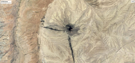
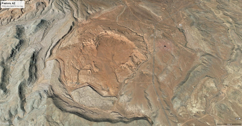
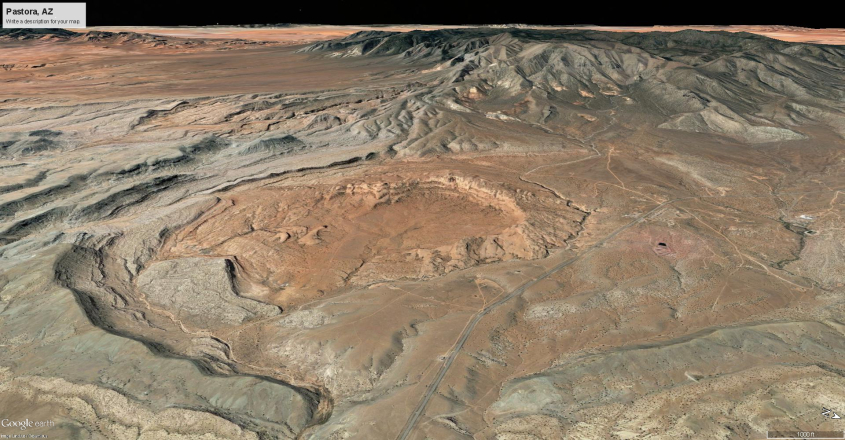
First, the strike forms a raised platform, with a shallow crater in the center where the lightning created an electrode spot. The rim of the crater is material swept inward by ionic winds and fused. There is a road cutting through the crater in the first image to give some perspective how large the feature is. These images are from Arizona, near Pastora Mountain.
A more sustained strike begins to accumulate neutralizing material on the spot, forming a flat-topped dome, like a pancake. As the material accumulates, the pancake grows to a mesa type structure, held together in a round form by the magnetic pinch.
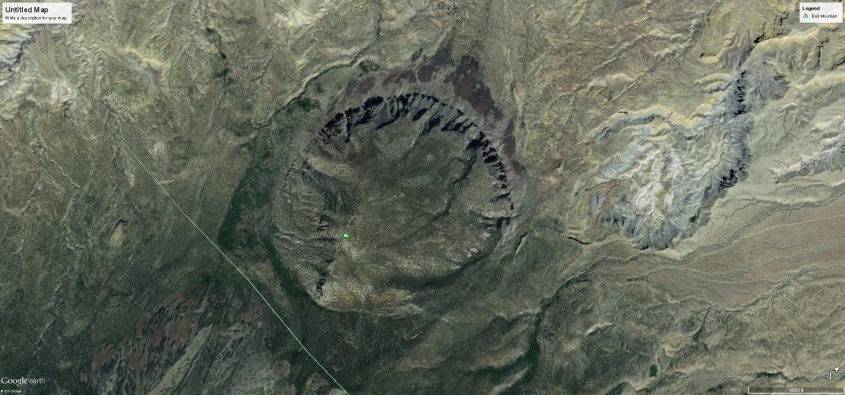
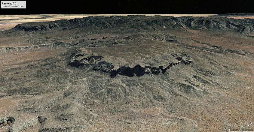
In the next phase of growth, the mesa grows taller and the inflow winds begin to reach mach speeds, creating shock waves that mold the rim material into triangular standing wave forms. A detailed discussion of this shock wave and the triangular buttress formations they create is presented more fully in previous articles on Arc Blast.
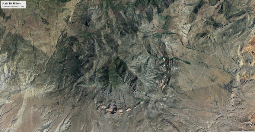
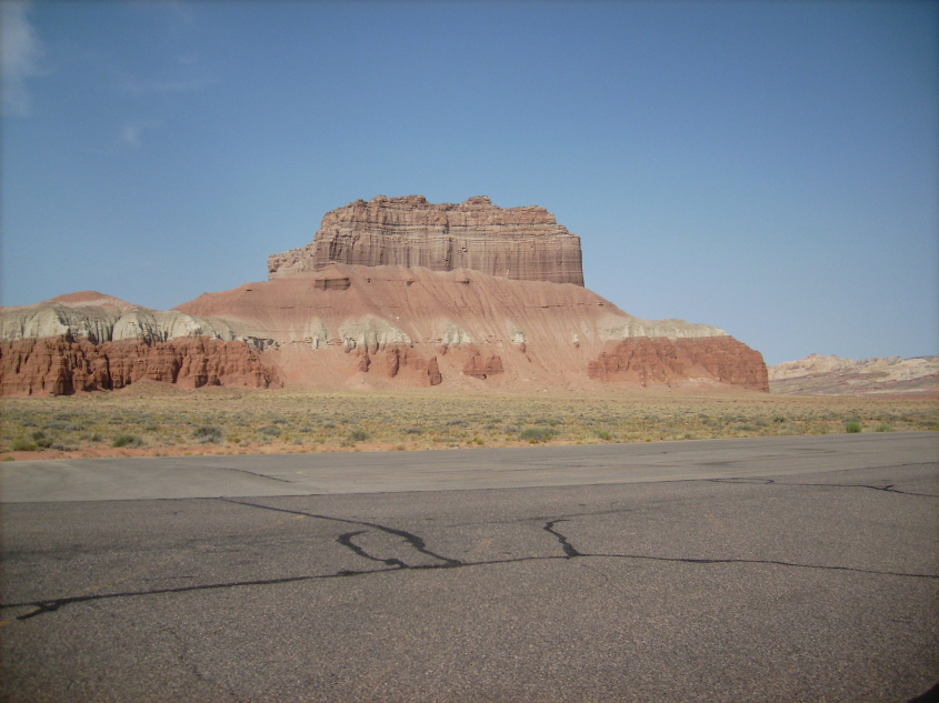
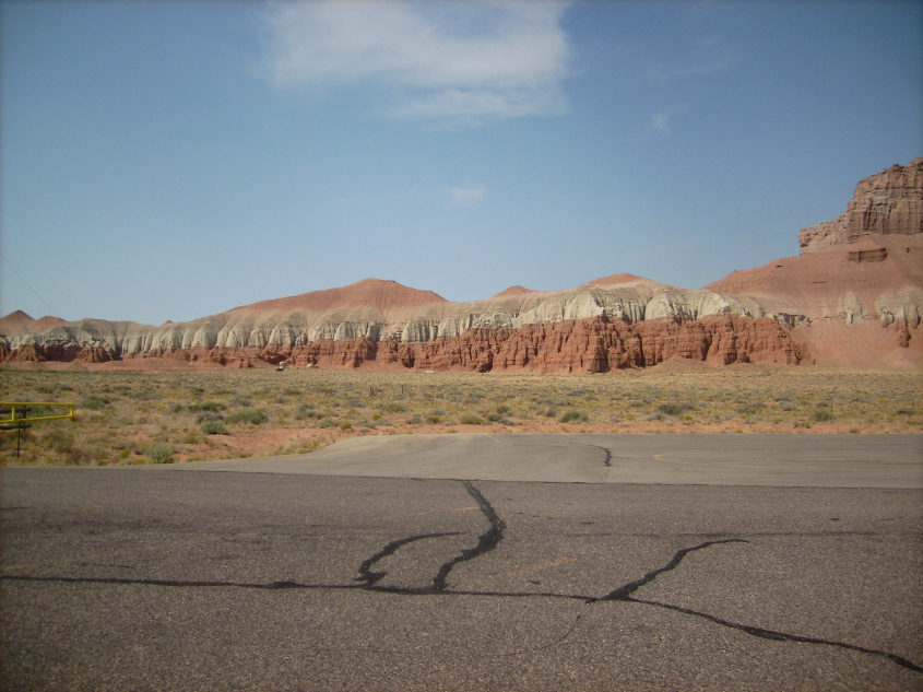
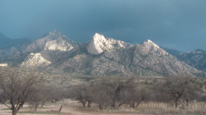
Mt Hillers, Utah – Hard rock buttresses form a nearly perfect circle around the base from in-flowing supersonic winds.
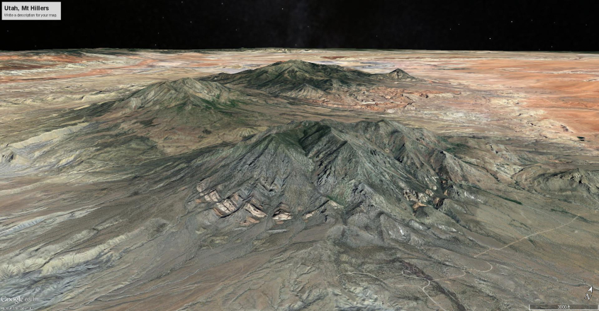
Mt. Hillers, ringed by shock-formed buttresses, lies in a complex of lightning formed mountains. Less developed craters and domes can be seen behind it.
As neutralized material builds, the anode spot the lightning connects with is at the top of the mesa, and rises with it. The strength of the pinch narrows the top forming a cone, and new regions of windblown, fused and shock-shaped buttresses form rims outside the older rim.
Left to right, the conical head of a fulgamite and concentric rows of granite buttresses. The dark vegetation band below rocky buttresses shows consistent angle of dip created by wind blown deposition – Buster Mountain, southern Arizona
The difference between lightning formed pinnacles like Shiprock, and the broad mountain forms shown in these images, seems to be polarity in the lightning. This interpretation is preliminary, but it appears that positive lightning burrows into the ground to connect with negative ionic matter beneath the surface, whereas negative lightning attracts surface winds and dust to it.
Positive lightning raises a narrow pinnacle of negatively charged material that boils up from the ground, with dykes which display the current path through the subsurface. Not much material is drawn to it from the surroundings, except for the sheath of rock it forms around it.
Negative lightning connects with pools and streamers of positively charged matter at the surface, and pulls huge amounts of airborne dust to create a dome with hardened, buttressed rims.
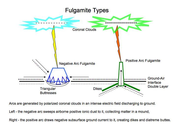
In both cases, mountains can form around them due to ambient winds and blowing dust. Positive arc fulgamites can form monoclines along the dykes, if ambient, supersonic winds strike them to create a standing wave, where dust piles into long, linear ranges of triangular wave forms.
Monoclines form against fulgarite dykes – San Rafael Reef, Utah
Blue dots and lines denote fulgurites and dykes in Comb Ridge monocline, Arizona
Fulgurite (right pinnacle) and dykes walls behind Comb Ridge monocline.
The last images above, taken at Comb Ridge monocline in northern Arizona, shows where fulgamites and dykes are exposed in the monocline. These protrusions created a shock wave in mach speed ambient winds that formed a linear standing wave, against which the monocline was formed like a dune, as blowing dust accumulated. There are several monoclines on the Colorado Plateau that exhibit the same, or similar features.
Negative arc fulgamites create their own winds, bringing dust to pile against them from all directions, and if powerful enough, form standing shock waves that generate buttresses in a ring around the base.
Fulgamite peak in Utah, near Capitol Reef.
Fulgamite forms central peak in Utah Mountains, near Capitol Reef.
Circular fulgamite features in Utah mountain range. Note the raised rims around the features built by inward flowing winds.
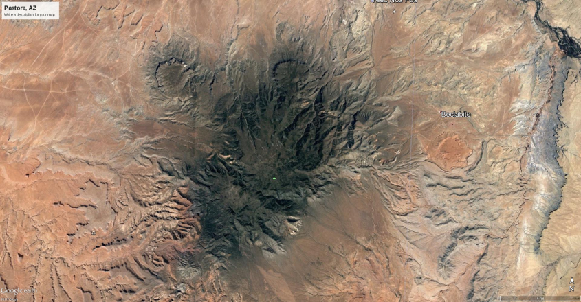
Circular fulgamite features in and around Pastora Mt., Arizona.
The circular craters and mesas in the images were formed by lightning, while the mountain was expanded by wind borne dust accumulating around them. There are several examples of mountains with these features in the Four Corners region.
Mountains are a misunderstood feature of the planet. Geological concepts are based on rocks forming deep in Earth’s crust and being exposed by erosion and tectonic motions, entailing, of course, hundreds of millions of years. It’s a very complex process that has not, and cannot be witnessed, or confirmed by experiment.
Mountain formation by wind and electric discharge, however, can be witnessed in nature. Sand dunes are a prime example. Mountains can also be produced in laboratories. So can rock. It happens when slag is produced from welding, ore and metal processing, or from chemical reactions like cement. Atomic and molecular bonding is an electrical process – the exchange and sharing of electrons.
Electricity and wind is a far more plausible mechanism for mountain building than what is proposed by the consensus theories. Especially since the actions of wind and lightning that formed mountains on Earth can be seen in any thunderstorm. One only needs to extrapolate the forces and energies involved to what they would have been when Earth was in a much stronger electrical environment.
Amplify the electric field of a thunderstorm by orders of magnitude, and it will produce an ionized atmosphere, screaming with supersonic winds, ionized dust, and incredible discharges of lightning that dwarf what we experience today. For examples, we need only to look at our neighboring planets. These conditions exist on Jupiter, Saturn and Venus. Why would Earth be any different.
Thank you.
Quick Tip
Please help support The Daily Plasma.
$2.00
Please, Like and Share this post:
Filed under: Electric Earth, Electric Universe, geology
Electric Earth January 13, 2018
[
Lightning Scarred Earth – Part 1
](Lightning Scarred Earth – Part 1 – The Daily Plasma)
Originally Published in Thunderbolts. info
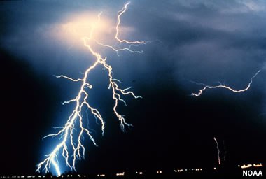
The blue-white arc of a lightning bolt stuns the senses. Blinding radiance, elemental beauty, awesome power and primordial danger flash into existence from thin air, and vanish before the mind catches-up. We stare, immobile, unthinking and awestruck.
In that moment, a channel of air the diameter of a quarter heats fifty thousand degrees, as trillions of electrons cascade to Earth. The volume of air blows-up, radiating energy across the spectrum, sending sonic booms across the sky.
Lightning also pummels the land, creating pressure waves exceeding seventy-thousand atmospheres – that’s one-million psi. It can create a layer of shocked quartz and vitrify surrounding rock into glass.
Lightning is an interaction between Earth and sky. It’s cause is an electric field between the electric storm above and the ground beneath our feet. ‘Ground’ is also a technical term, meaning the ambient voltage potential of the soil.
Earth is a negatively charged body in space, and current flows up from ground to atmosphere, normally in a drift of ions and electrons that is invisible. Storms reverse the current flow, causing electrons to avalanche back to Earth.
The Earth and sky are part of a circuit. Storms result from capacitance in the circuit. The atmosphere stores energy in the form of ionic charge, and releases it through lightning, among other effects.
 The ground is one plate of the capacitor where positive charge collects. As negative charge builds in the cloud, it is repulsed from the ground below, and positive ions are drawn in.
The ground reaches up with plasma tendrils. They collect especially around tall structures, pooling densely at sharp projections, surrounding them with a halo of charge the cascading electrons target for connection.
When connection is made, the arc touches Earth, spreading current in horizontal arcs across the surface as much as twenty meters away. This is a death zone. If you are in it, you are part of a 200,000 amp circuit.
The horizontal arcing is a side flash – a scatter of arc tendrils that follow surface conduction across the ground, radially away from the point of impact. The ground potential, type and shape of surface influences the character of the side flash.
Dry sand acquires charge very easily. Lightning attracts charged particles, and will sweep sand to it leaving a display of the entire strike zone. Sand in the strike zone, where current surges across the surface, pulls inward leaving a shallow crater with a cone of sand in the center. It’s like grabbing a bedspread in the center, pulling it up and dropping it in a pile.
The following photos were taken near Kayenta, Arizona on desert plains to the south of Comb Ridge.
The form is like an anthill, but these are not anthills. Ants dig rock from below ground and pile it outside the hole. These are built the opposite. The sand is swept-up from the surroundings, leaving a pile at the center of a crater. Besides, these don’t have ants, or ant-holes.
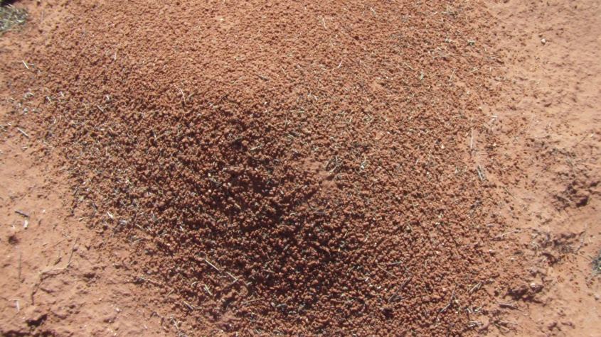
Darkened, fused sand pebbles dust the surface of the mound of powder. No ants, no hole.
The mounds of sand are composed of fine, almost powder sand. But the tops of the mounds are dusted with pebbles. The pebbles are sand drawn into the lightning channel that fused and fell back to Earth when the flame extinguished, falling to cover the mound, like candy sprinkles on an ice cream cone.
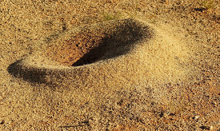
This is an anthill
Nothing grows inside the craters, or on the mounds. It’s as if the soil is sterilized. PH tests show the soil to be highly alkaline.
What meager growth there is are low, ground covering grasses and weeds around the perimeter of the craters.
The desert in this region of Northern Arizona is carpeted with lightning strikes that left crater and mound features like these. The land is on the Colorado Plateau, just south of Monument Valley. They form what some call fairy rings when seen from the air.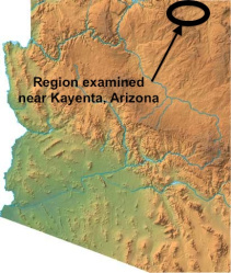
The next images show clusters of them. The craters vary in size from fifteen to thirty feet in diameter, or larger. The size of the central cone is proportionate to the size of the crater, ranging from about eight, to eighteen inches tall.
Fairy rings are lightning strikes that made shallow craters with central peaks. Nothing grows inside the strike zone. The darkest areas are covered in broken rock, except where lightning has excavated the craters.
The strikes especially cluster where black rock crusts over the sand. The lightning seems to have punched through, scattering rock and leaving the craters bare, where nothing grows.
Whether the lightning is attracted to the rock, or the rock was made with the lightning isn’t known, but the rock provides a clue. It appears the lightning came in a coherent event that peppered the land, punching through and shattering the rock. That, at least, is how it appears. It’s as if there were two events. One that torched and melted the surface of the land, creating the cap rock, and a subsequent one that shattered the rock with lightning.
What amazes is the number of them clustered in particular areas. They rarely overlap, spaced fairly even, but randomly apart. There are hundreds of thousands, if not millions of them scarring the land just south of Comb Ridge.
There are regions around the world where features like these carpet the land for hundreds of square miles. They are seen in desert lands especially, since there is little undergrowth to obscure them. The next image is from Namibia. Here the features connect with filaments of stream beds. But note how they connect in linear arrays, and branch radially like little stars. They are electrical discharge patterns.
Each feature seems to be a shallow basin, or spring where water collects. Map resolution doesn’t allow better detail. These features are larger than the Arizona features. Many cover several acres.
Much of the country of Uzbekistan is carpeted with similar features, as the following images from a small portion of eastern Uzbekistan show.
The Uzbekistan features are larger and more numerous still. They also appear to be shallow basins where the geology is distinctly changed, and there appears to be a source of water. In the last image, there appears to be a home, or ranch with a livestock tank, well, or catchment at the center.
It makes sense that water is found where lightning has struck. Subsurface water is a source of ionization that intensifies charge density, and therefore the electric field, attracting lightning to it’s location. Standing surface water won’t do that because ions have no point to collect – they spread evenly over the surface of the water. But subterranean water is trapped in the earth, where ions collect and build concentration, locally intensifying the electric field. Pits, craters and rilles formed by lightning leave depressions over aquifers that are natural for springs and wells.
But what about larger features – bigger than pits and piles of sand. Can lightning make a mountain?
Volcanoes form mountains by extruding molten rock to the surface from hot pools of magma beneath the crust. This is conventional understanding, and it isn’t in dispute in the Electric Universe. After all, volcanoes can be witnessed doing this in real time. The resulting strato-volcanoes, cinder cones, lava flows, ash deposits and lahars are seen across the globe.
What creates magma chambers and causes them to erupt is not understood. Consensus science has a number of speculative theories based on conventional beliefs about the make-up and dynamics of the interior of the earth. It’s these theories EU has a problem with. EU theory proposes the mechanism for heating and erupting volcanoes is electrical discharge beneath Earth’s crust. But our theories are also speculative because there is no way to look inside the Earth to be sure.
One type of geologic feature attributed to volcanism can be challenged by EU Theory however. These are buttes believed by the consensus to be the ancient throats of volcanoes, where a magma plug froze in the throat, and later erosion exposed them leaving a hardened pinnacle.
Shiprock – made by Star People
Archetypal is Shiprock, a tall butte that lies near Four Corners, where the U.S. States of Arizona, Utah, Colorado and New Mexico meet. It lies in the heart of Navajo lands.
Some Navajo traditionalists argue Shiprock is the work of the ‘star people’. Could it be they know more about it than our consensus scientists do.
We can use this butte and the surrounding landscape to discuss how such features were actually formed by lightning in the distant past, when lightning was a thunderbolt of the Gods. But first, let’s look at some of the absurdities in consensus theory concerning its formation.
Shiprock does sit near a region of true volcanic activity. Northern Arizona has volcanoes along the Mogollon Rim that lie to the South and West of the four corners region. This is part of a super-volcanic complex much like Yellowstone.