Originally published on skywebsite.com/hollow/arctic/id20.html (2002-04-28), a page of Dean De Lucia's website; recovered from the Internet Archive.
An earlier version of Curvature Anomalies: Why the Horizon Drops Off at the North Pole, in Dean's Corner.
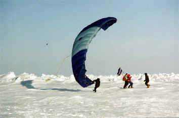
North Pole Pictures, above and below.
[image missing: arctichorizon.gif]
These pics are *not* like pictures of the horizon as seen from Texas or Oklahoma or some place like those. Pictures from those places show a horizon that just stretches on and on. At the North Pole, where the curvature is supposed to flatten out a bit, the horizon should stretch out even further. Instead of that, we see the opposite in the above pictures. We see that the horizon drops off shortly. This effect is obvious even though in the top picture there is an ice spur in the near distance, and the other was taken from a slight elevation, maybe from on top of a vehicle like a helocopter that was parked there or from the wing of a plane. The second pic is taken from shoulder-high elevation at least. But even with the spur in the way and even though that one pic is taken from a slight elevation, the effect is obvious- foreshortening of the horozon.
When Peary- and also Cook- approached the North Pole, they both reported exaggerated sledding speeds ( Siberian husky dogs and all that ). Why? Because the terrain not only flattened, but was curving inwards rather sharply. So a little distance covered made for more-than-normal lateral progress, cutting striaght across, so to speak, rather than up the normal curvature of the Earth. This is something that showed up in their latitude calculations, and something which was symptomatic of travel along a flattened Earth, if not an Earth angling inward. This abnormal sleddingspeeds increased as Peary approached and departed from the immediate proximity of the Pole. Right as he left, he covered a 153 miles in 48 hours, over Arctic ice, on a sled, running over rough ice terrain and such. this is hardly believable- one could hardly bicycle that far in 48 hours over good roads.
He did tell the truth. It is just that the sharply flattenening curvature played havoc with his latitutde calculations, exaggerating his lateral progress.
Keep in mind that the opening is located somewhere between the Pole and the New Siberian Islands. That means that the closer that you approach the Pole from Greenland and Northern Canada, the sharper that the inward curvature becomes. This is what Peary and Cook experienced without realizing it. And there were other explorers who experienced the same without being able to interpret the effect.
Here is what I have gathered together on the subject matter in my article Seven Days North of Tibet. You will notice that curvature anomaly has been documented from the side of the New Siberian Islands, as well as from Northern Canada. If the inward curvature continues from opposite sides of the Arctic circle, what happnes in the middle? The curvature opens up and turns into the opening to the hollow world, that's what. From Seven Days North of Tibet:
" At this time, their position was just a little above 78* 15 North, only a few degrees from the polar opening. ( They felt that they had temporarily back drifted from where they had originally reached the ice ) The fact that the Sun had disappeared below the horizon, introducing the long Artic night, at that time and from that latitude, indicates that the grade of the Earth's curvature diminishes at the poles, which is something that science certainly accepts- such flattening can even be seen in astronomical photographs of other planets. But what is not understood by most is that such flattening is indicative of a curvature which rounds gradually inwards. We will touch on the theme of curvature again."
" On page 126 of Nansen´s book, disappointment is described as the navigator all of the sudden determines the ships position to be various degrees South of where they had calculated. Now, it is not reasonable to assume that an error had existed all this time, which was not caught until that moment. Their navigator was Sugurd Scott Hansen, an officer of the Norwegian Navy and an academy graduate: Could it be that the current had the ship straddling the rim of the funnel-like opening, North and back South, falsely indicating exaggerated movements in terms of latitude? It seems that the curvature of the polar opening was playing havoc with the angle of their sextant, and the indications derived from the readings."
" Now we touch on the anomaly of curvature again-
Page 288: [ April 6th ] It became more and more of a riddle to me that we did not make greater progress Northward. I kept on calculating and adding up our marches later on, but always with the same result ... we must be far above the 86th parallel. It was becoming only too clear to me that the ice was moving southward.
" Page 291: [ April 14th ] I find that we should yesterday have come farther South than 86* 53 North; ... I cannot explain it in any other manner than by the surmise that we have been drifting rapidly northward, which is very good for the Fram, but less so for us [ on foot ].
" It was between these two log entries that Dr. Nansen and Johansen had turned back. Here we find that within the space of a few days, Nansen blames his navegational anomalies on the ice drifting Southward then Northward. More likely, they were very close to the rim of the doughnut-like opening into the hollow portion, and the curvature changes were confusing Dr. Nansen, indicating paucious movement in terns of latitude, and rendering his sextant unreliable. There was a Northward current at the time because the ship Fram, which was still in the vicinity, had drifted Northwards also. This current would account for the retarded Southward progress of Dr. Nansen and Johansen. But their scant Northward/lateral progress prior to the turnback had to have been due to travel over the curved rim of doughnut-like opening.
" Lt. Greely ( Later General ) also indicated curvature anomalies, from several hundred miles away, and to one side of the basin from Nansen; Nansen was now on the Russian side above Franz Josef Land, and Greely had been over towards the tip of Greenland and Canada. Lt. Greely's description, since he had landmarks at his disposition, specifically smack of forshortening of the horizon, such that spurs of land at the horizon seemed high out of proportion, and cut off the view beyond. In our " polar opening " scheme of things, this blocking-of-the-view would simply be due to an exaggerated bulging and pinching of the horizon as it angles into the opening. At this point, Greely was near the tip of Greenland, near the Pole ( a few hundred miles ) and near the opening. Let us consider his comments:
Culled from The Hollow Earth, page 104:
" The deep interest with which we had hitherto persued our journey was now greatly intensified. The eye of civilized man had never seen, or his feet trodden, the ground over which we were traveling. A strong, ernest desire to press forward at our best speed seized us all. As we neared each projecting spur of the land ahead, our eagerness to see what was beyond became so intense at times as to be painful. Each point we reached brought a new landscape in sight, and always in advance was a point which cut off a portion of the horizon and caused a certain disappointment."
If Greely and his companions were entering into the interior of the Earth, they would certainly find that the Earth has a greater curve near the poles than at any other place; ... Foreshortening of the horizen can also be seen in photographs of the North Pole area; the horizon seems to come up closer than it should.
Admiral Peary made a similar observation: " The black cliffs peer up over the ice caps." This indicates an exaggerated curvature, sloping inward towards the North, that in the near distance, only the peaks of the hills popoed up into view above the horizon.
Due to polar anomalies in terms of compass ( longitude ) and curvature ( latitude ), Dr. Nansen and crew had been unable to precisely calculate their position since the first moment that they had lodged their ship into the ice. At this point, trekking on foot down from the Pole, he and Johansen were still quite unsure of their position thanks to the curvature anomalies just described, and to the drunken compass readings along the rim of the opening. They remained unsure for a long time as they headed straight down South on the Russian side of the Pole. As they descended from near the Pole, however, the nature of their navigational difficulties took on a different nature. They became problems in terms of longitude because they had let their watches run down- not latitude. Their difficulties in determining their longitude at this point were not anomalous. ( As an example, by June 14th, Nansen recorded his position to be 57* 40 of longitude but, later on, once he got back to civilization, he felt that it had been more like 6* further East of that. ) As he and Johansen headed South towards Franz Josef Land, Dr. Nansen wasn´t even sure on which side of the archipelago they would come down on!
The Archive · skywebsite.com — The Hollow Earth · Dean's Corner