A 5000 Year Old Map That Shatters The “Official” History of The Planet !

List members , we've often discussed about the Piri Reis map on this forum , but please do read this article - it is extremely well researched and provides astonishing new insights from that ancient map :-

A 5000 Year Old Map That Shatters The “Official” History of The Planet

BYARJUN WALIA

NOVEMBER 17, 2022

8 MINUTE READ

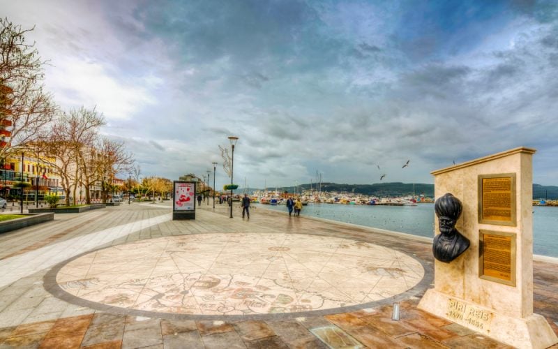
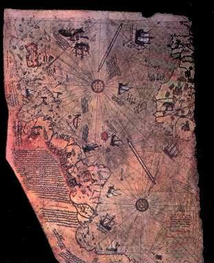
Canakkale, Turkey. The Piri Reis map displayed next to a monument honouring Piri Reis. Image via Shutterstock.

IN BRIEF

  • The Facts:
    • The Piri Reis map is a genuine document that was copied at Constantinople in AD 1513 from older documents and discovered in 1929.
    • The original dates back to at least 5000 years ago.
    • It provides startling evidence of a lost civilization that may have been more advanced than anyone could have imagined.
    • The map may have been made by access to Ariel views, or by extremely advanced scientists skilled in the art of determining astro-positions and the methods required for topographic surveying.”
  • Reflect On:
    • How did the makers of this map know their longitude so precisely?
    • How were they able to discover features of our planet that were only discovered by modern civilization several decades ago?
    • How did the map have a record of every mountain range in North America and Canada, some of which were not known to the Army Map Service until the 1950's?
    • Why does the map depict an ice free Antarctica when it was supposedly covered with ice?
    • How could this map have been so accurate so many thousands of years ago, when the scientific methods of mapping have just recently come to be known?

Human history is quite an enigma. We know so little, and much of what we think we know is always subject to change since information constantly emerges that challenges our current understanding of the world.

Our world is also no stranger to unexplained mysteries, and there are numerous examples of verified phenomena, ancient monuments, books, teachings, understandings, and more that lack any explanation and counter what we’ve already been taught. We are like a race with amnesia, as author Graham Hancock once said, able to put together small bits and pieces of our history yet unable to fit it all together. There are still many missing pieces to the puzzle.

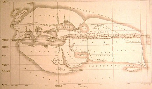
One great example is the Piri Reis map, a genuine document and world map that was copied at Constantinople in AD 1513 from older documents and discovered in 1929. A German theologian named Gustav Adolf Deissmann was cataloguing items in the Topkapi Palace library in Istanbul when he happened across a curious parchment located among some disregarded material. The original is at least 5000 years old. Unfortunately the full map in its entirety was never found.

It was drawn by Admiral Piri Reis of the Ottoman era, a well-known historical figure. He made a copy of the map, which was originally drawn based on documents that date back to at least the fourth century BC, and on information obtained by multiple explorers. Reis was well known for his interest in geography and navigation.

“The Piri Reis’ Maps, presumed to have been made over 5,000 years ago, give startling evidence of a lost civilization that may have been more advanced than anyone could have imagined. There has been much controversy about them in recent years, and there is much more to be discovered.”

Carris S. Astronomy A20, Northwestern University, 1968. A Paper written by one of Dr. J. Allen Hynek’s students.

Piri Reis had a pilot who was a salve, this slave had been with Christopher Columbus on three of his voyages. When captured, the pilot was found to possess maps used by Columbus. Reis used this and eight other Greek maps that were handed down from Alexander the Great to make his world map.

In one of his notes, Piri Reis personally explains the manner in which the map came into existence:

“This section shows in what way this map was drawn. In this century there is no other map like this in anyone’s possession. The hand of this poor man has drawn it and now it is constructed. From about twenty charts and Mappae Mundi – these are maps drawn in the days of Alexander, Lord of Two Horns, which show inhabited quarter of the world; the Arabs name these charts Jaferiye – from eight Jaferiyes of that kind and one Arabic map of Hind, and from the maps just drawn by four Portuguese which show the countries of Sind, Hind, and China geometrically drawn and also from a map drawn by Columbus in the western region, I have extracted it. By reducing these maps to one scale this final form was arrived at. So that the present map is as correct and reliable or the Seven Seas as the maps of these our countries are considered correct and reliable by Seamen.”

“Piri Reis’ Map,” Maps Division, The Library of Congress.

Why The Map Is So Compelling

One of the most compelling facts about the map is that it includes a continent that our history books tell us was not discovered until 1818. Again, the map is at least 5000 years old.

The map shows the coast of South America, Africa, and Antarctica with precise detail. This means that there were competent explorers and map makers thousands of years before Columbus.

“For instance, the drawn coast line of the Antarctic shows the line which is now under the ice cap, but must have been surveyed twenty centuries ago. It has been said that the cartographers who prepared these maps were members of survey teams who had visited almost the entire earth. They were not adventurers, but competent scientists skilled in the art of determining astro-positions and traverses.”

Carris S. Astronomy A20, Northwestern University, 1968. A Paper written by one of Dr. J. Allen Hynek’s students

In the 1950’s, the Head Engineer of the Hydrographic Office of the US Navy gave Arlington H. Mallery, author of “Lost America” and a well known authority on ancient maps, along with M. I. Watlers, a cartographer formerly with the United States Hydrographic Office, a copy of the map. They found that, with precise accuracy, the various land and water areas in their exact location. According to them, the maps “bring home to us the fact that the oldest human records that we have that are absolutely authentic are navigational charts.”

“They found, after much intensive examination, that Columbus had a map with him that showed accurately the Palmer Peninsula in the Antarctic Continent. The problem of how they could have been so accurate so many thousands of years ago, when the scientific methods of mapping have just recently come to be known was puzzled over by them both. They said that there was very little ice then, but the map had a record of every mountain range in North America and Canada, some of which were not known to the Army Map Service. They have since found them. Mr. Mallery said: “Just how they were able to do it – you will probably recall the tradition of the Greeks of the airplane – maybe they had the airplane.” (This idea could even be brought so far as to consider the idea of UFO’s, or a superior being from another part of the universe, producing the maps, as well as an advanced civilization inhabiting our own Earth.) Also, they knew their longitude absolutely correctly – something that we did not know until about two centuries ago.

Carris S. Astronomy A20, Northwestern University, 1968. A paper written by one of Dr. J. Allen Hynek’s students

Mallery goes on, emphasizing the fact that these explorers and map makers were, as already mentioned, clearly well before the time of Columbus, and that they were:

“Not only explorers, but that they must have had a very competent and far flung hydrographic organization, because you can’t map as large as a continent as Antarctica as they have, half of it, or as extensive an area as Greenland or half of the continent of North America, as we know they did do, probably 5,000 years ago, it can’t be done by any single individual or small group of explorers. It means an aggregation of skilled scientists who are familiar with astronomy as well as the methods required for topographic surveying.”

It makes me wonder, perhaps they had assistance from the indigenous at the time, again, more than 5000 years ago. Another quote comes to my mind here by Richard Wagamese when Mallery mentioned assistance from elsewhere, I thought it was somewhat fitting. Wagamese was a well known Ojibway author and journalist from the Wabaseemoong Independent Nations in Northwestern Ontario, Canada. He once wrote,

“My people tell of Star People who came to us many generations ago. The Star people brought spiritual teachings and stories and maps of the cosmos and they offered these freely. They were kind, loving and set a great example. When they left us, my people say there was a loneliness like no other.

“Star People” by Richard Wagamese

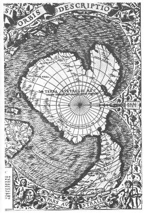
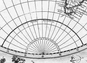
The Piri Reis map depicts what is known as “Queen Maud Land,” a 2.7 million-square-kilometer (1 million sq mi) region of Antarctica, as it looked many years ago. This region and other regions shown on the map are thought to have been covered completely in ice at the time, but the map tells a different story, showing them free of ice, which suggests they passed through a long ice-free period that may not have ended until around six thousand years ago. This conflicts with current research on these areas. Today, geological evidence has confirmed that this area could not have been ice-free until about 4000 BC.

The map shows that the ice age took place at a much later time than thought. The ice glacier that was shown on the map of North America was in existence 15,000 years ago and disappeared, presumably. But this map shows that glacier only 5,000 years ago. Other maps indicate that the glaciers had disappeared or else had not appeared at the time these maps were made, or had only begum to appear..

Basically, the official science has been saying all along that the ice-cap which covers the Antarctic is million years old. The Piri Reis Antarctica map shows that the northern part of that continent has been mapped before the ice did cover it. This is unexplainable, and it’s unfathomable to think that this map actually originated millions of years ago.

The map, again, is also precise and exact with longitude, and the location of everything is precise with what we know today. There are several examples showing this. The map also contains details of the terrain, the mountains, perfect coast lines, with rugged and numerous mountain ranges.

Professor Charles Hapgood, who was a university history professor, wrote to the United States Air Force Reconnaissance Technical Squadron (SAC) and they also confirmed that “this indicates the coastline had been mapped before it was covered by the ice-cap.” They also went on to state that “we have no idea how the data on this map can be reconciled with the supposed state of geographical knowledge in 1513.”

Here’s what Hapgood had to say about it in his book Maps of the Ancient Sea Kings:

“It appears that accurate information has been passed down from people to people. It appears that the charts must have originated with a people unknown and they were passed on, perhaps by the Minoans and the Phoenicians, who were, for a thousand years and more, the greatest sailors of the ancient world. We have evidence that they were collected and studied in the great library of Alexandria (Egypt) and that compilations of them were made by the geographers that worked there.”

Furthermore, the map is very detailed and includes mountain ranges in the Antarctic and other parts of North America that were not even discovered until 1952.

“His idea is original, of great simplicity, and – if it continues to prove itself – of great importance to everything that is related to the history of the Earth’s surface.”

Einstein on Hapgood’s interpretations of the map.

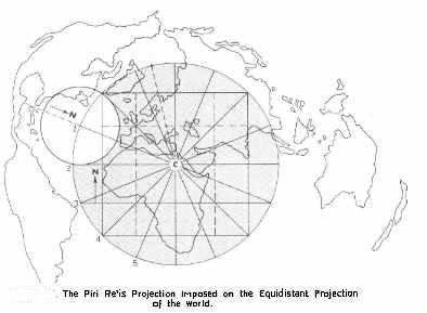
Hapgood and mathematician Richard W. Strachan have also provided more interesting information. For example, a comparison with modern day photographs taken from satellite images shows remarkable similarities; the originals of Piri Reis’ maps might well have been aerial photographs taken from a very high height. How is this possible for a map that was made 5000 years ago, or perhaps even earlier?

“A spaceship hovers high above Cairo and points its camera straight downward. When the film is developed, the following picture would emerge: everything that is in a radius of about 5,000 miles of Cairo is reproduced correctly, because it lies directly below the lens. But the countries and continents become increasingly distorted the farther we move our eyes from the center of the picture. Why is this? Owing to the spherical shape of the earth, the continents away from the center ‘sink downward.’ South America, for example, appears strangely distorted length-ways, exactly as it does on the Piri Reis maps! And exactly as it does on the photographs taken from the American lunar probes.”

– Erich von Däniken, Chariots of the Gods

Changing Our View of The Past

The fact that this map could have been made with some sort of aerial technology is quite a thought, isn’t it? Even if this isn’t an option, who had the ability to undertake such an accurate geographical survey in Antarctica and other parts of the world so professionally such a long time ago? How would they have known to detail the map as if it were taken from above, with knowledge about the Earth’s shape and more? How would they be able to determine their longitude?

There are so many unanswered questions.

Regards

1 Like

Folks , it is quite obvious that this ancient map was made basis of an aerial survey of the globe...there are only two ways this could be explained - either ancient Vimanas , possibly of the Hollow Earthers , were involved , OR the UFOs of extraterrestrials !

Regards

Sidhartha,

I imagine that the map is a leftover from the times before the great flood.

We can say that the ones who possessed technology abandoned, as far as we can tell, humanity of the surface of the globe. If not immediately, over time they did so. The technology, for example, of flight.

Cheers!

1 Like

Yes , quite possible @deandddd .

The very fact that this ancient map shows Antarctica WITHOUT the ice sheet (!!) , means the observations were made even BEFORE ?? Antarctica got covered by an ice sheet , OR they had advanced GPR type technology back then to peer beneath the ice sheet !

Either way , the accuracy of this prehistoric map is mind boggling :))

Regards

1 Like

Sidhartha,

Here is the Frobisher map, the map that Martin Frobisher carried with him, as he went to explore the Arctic during the times of Sir Francis Drake.

It seems to depict the topmost/northernmost edge of the inner continents(s). It is as if the mapmaker didn't realize that he was heading over the edge, towards the top of the inside. He seems to connect it to the outside as if it were one-flat plane. He seems to be oblivious to what he is depicting.

Cheers!

http://www.holloworbs.com/Frobisher.htm

1 Like

Is there a larger clear image of this from overhead @sidharthabahadur?

@Western0bserver , here is another indepth article (with some images) :-

The Piri-Resi Map: (Prehistoric Cartography)

Potentially one of the most significant finds of modern time as it is clearly dated 1513 AD and shows both the coastlines of the American and debatably, the Antarctic coastline (which has been frozen over since around 4,000 BC). This map alters all previous conceptions of our pre-historic ancestors abilities. The 'Piri-Reis' map is one of several 'portellano's' which appear to have a geometric basis of unknown provenance. It has several interesting features which deserve investigation, such as:-

The map has pre-Columbian provenance.

The map shows the coastline of America.

The map shows accurate use of Longitude and Latitude.

The map-builders used 'Spherical geometry'.

The map centres at the junction of the 23.5 ˚ parallel (Tropic of cancer), and the longitude of Alexandria. \ 296x382

The Discovery:

In 1929, a section of a world map drawn by the Turkish Admiral Reis (Piri-reis), was found in the basement of a museum in Constantinople. The map was of immediate interest as it appeared to show the coastlines of South America and Africa at their correct relative longitudes and latitudes, and the legend on the map dated it to 'Muharran' in the Moslem year 919 (1513 AD), only 20 years after the official discovery of the Americas by Columbus in 1492. The legend on the map itself however, gave it an origin far older than 20 years, revealing that it was a section of a world map composed from more than twenty source maps, some drawn in the time of Alexander the great, and that 'some were based on mathematics' (4). The fact that there was no known means of accurately calculating longitude in 1513 AD led Prof. Charles Hapgood to examine the map further.

Hapgood's research led him to make several fundamental conclusions; Firstly, he confirmed that the coastlines of the continents had been accurately plotted with regards to both latitude and longitude. Secondly, he determined that the co-ordinates had been mathematically converted from natures spherical model to fit the two dimensional representation of a map, (a method similar in principle to Mercator�s projection). Thirdly, he showed that a connection existed between this map and several other ancient portolano�s and mappa-mundi, some of which included the outline of the Antarctic continent. These facts led Hapgood to suggest the existence of a set of knowledge from a time before the Greeks, and placed a question mark over the origin of sciences such as geometry, geography and cartography, traditionally accredited to the Greeks.

Geometry and Longitude:

The presence of a Mercatorial projection on such old maps is significant as such high levels of geometry had not been seen since the time of the Greeks and it was not until the work of Gerald Mercator in 1569, that European�s began to include a projection for the curvature of the earth into their maps. We can be fairly sure that the inclusion of such a projection was not the work of Piri-reis, as he left several cartographic errors of his own (such as skewed sections of coastline, and the duplication of the Amazon river), which testified to the fact that the Piri-reis map is actually a montage of other maps, and he admitted himself that his world map was �composed with the use of other source-maps' which therefore already included the projection. An association of such knowledge even as far back as the Greeks, is in itself, an achievement worthy of merit.

We can see that the horizontal lines on the map are geographically (and astronomically) significant, with the Equatorial line sitting correctly between the Tropics of Cancer and Capricorn, both of which are also marked with �Rose des vents�. The inclusion of vertical lines marking the correct longitudinal separation between the African and South American continents identifies the map as having a cylindrical projection, a feature which is not seen on maps before this time, or for another fifty years until Mercator presented his map to the world. This identification of the Tropics within the geometry of the map confirms the suspicion that a knowledge of astronomy was available to the original cartographer, who also used the Tropic of Cancer to mark the geographic centre of the map (4).

The calculation of latitude is a relatively easy procedure requiring only a single observation of the height of the sun from the horizon, the length of a shadow or the height of the pole star in the sky, whereas the calculation of longitude is a more complicated figure to deduce. It is because of this that off-shore navigation was for a long time at best educated guesswork (dead-reckoning), a situation which became an anathema to the European scientific community for several hundred years, managing to elude some of the greatest scientific minds of the time (Galileo and Newton included), and it was not until 1760 that success was eventually realised in the shape of a precision ships-clock or chronometer, and world maps were re-charted accurately, and apparently for the first time. The development of such a timepiece meant that if a sailor reset a ships-clock at noon each day, and compared the difference between that clock and another unadjusted clock from a known longitude, the difference between the two could be translated into longitude (as each four minutes of difference between the two clocks translates into a single degree of longitude).

Apart from the possible exception to the Antykithera find, which may have functioned as an �astrolabe', the Greeks were known to have calculated longitude with the use of astronomy, as did several other cultures in history. A record from 14th century China states that �Wang Da Yuan achieved a transoceanic passage from Mozambique to Sri Lanka using a combination of compass and star linked positions called gouyang Qianxing to determine latitude and longitude� (28).

We know that this level of astronomy was not generally available in the west, and a workable means of calculating longitude was apparently still not known in Europe at 1540 AD, when the German astronomer Johanes Werner first proposed using the moon as a location indicator (19). (If an eclipse is predicted at a location at a certain time and one experiences the eclipse an hour earlier, then one knows that they are positioned 15 degrees east of their original location). While this system works well in the presence of an eclipse, their infrequency makes them impracticable as a method for sailors to use �on demand�, and relies on an accurate reading of the time of eclipse at both locations.

Apart from the fact that the map is dated at 1513 AD, long before the discovery of such an accurate method of calculation, Piri-reis himself states in the legend that it was a composite of several older maps, including some drawn �in the days of Alexander, Lord of the Two Horns..�, some ��Arabic Jaferiyes�� and one �...drawn by Columbo in the western region�. With regards this latter contribution from Columbus, he adds that ..

��it is reported thus, that a Genoese infidel, his name was Columbo, who discovered these places. For instance, a book fell into the hands of the said Columbo, and he found it said in this book that at the western end of the Western sea (Atlantic) that is, on its western side, there were coasts and islands and all kinds of metals and precious stones. Columbo having studied this book thoroughly, explained these matters one by one to the Greats of Genoa�� (4).

We therefore have several suggestions that this map at least, includes a set of knowledge that predates the European renaissance of the sciences which followed the intellectual vacuum of the �Dark-ages� under the shadow of the �Holy church of Rome� (a time when science was rejected as witchcraft and the world was believed flat). If it is the case that all the continents of the world were accurately charted onto a world map before this time, it would be an historic achievement and worthy of recognition in its own right, and it is the very presence of one of the continents that has generated the most debate. The coastline of the Antarctic continent appears accurately on several ancient maps although it has been covered by several miles of ice-pack from a time long before the Greek empire and the first officially recognised world map by Ptolemy in 150 AD. (19).

The Antarctic Coastline:

'Terra Australis Incognita'

The Antarctic coastline (Terra Australis Incognita) :

The recognition of the Antarctic continent on certain ancient world-maps may well turn out to be Hapgood�s most significant discovery as, apart from the fact that there is no record of anyone ever having charted the continent, it is a feat said by geologists to have been last physically possible only through a window of opportunity between 10,000 BC and 4,000 BC (4), a date that was arrived at through analysis of core samples taken from the Ross sea-bed, which established that sub-tropical flora and fauna were present on Antarctica during these dates, and following which a severe climatic shift resulted in the region freezing over. The conclusion of this fact is that the cartographers of the map would have had to have charted that region no later than 4,000 BC, (before the coastline froze over).

The presence of the Antarctic continent on the Piri-reis map is in debate, with suggestions that the bottom tip of the south American continent was simply �squeezed� on, following a miss-judgment in size by Piri-reis. Regardless of this, there are other ancient maps which clearly do have the outline of the continent on them, with both Gerard Mercator's map of 1569 AD and the Oronteus Finaeus map of 1532 AD (right), also showing the coastline, and the Hadji Ahmed map of 1559 AD, which not only has Antarctica with a correct Mercatorial projection but also shows a land bridge between the Bering straits, re-enforcing the suggestion of an antiquitous origin. The specific division of the Antarctic continent into two smaller land-masses on these ancient maps is similarly a mystery as it was only at the end of the 20th century that we were finally able to determine (through satellite technology) the accurate outline of the Antarctic continent, which was found to be identical to those seen on some of the oldest surviving maps of the world.

Hapgood�s research led him to identify another feature common to several ancient maps which was that the Antarctic continent occasionally appears greatly enlarged with details along the coastline remaining consistent to scale. It was through this particular finding that Hapgood realised that the line called the 'Circulus Antarcticus' which appears on maps at this time was the same as the 80th parallel on modern maps (made with a Mercatorial projection), and he suggested from this that the original maps had been made with a Mercatorial projection and divided into units of 10 degrees from a division of the globe into 360�, he then concluded that this original map was then later copied without realising that it already contained a mathematical compensation for the loss of curvature, which without a proper understanding of the lines on the map, resulted in an exaggeration of the land mass by around 4 times its actual size.

There are several significant implications attached to the discovery of Antarctica on such old maps. In particular, the use of longitude, along with its conversion onto a two-dimensional representation implies a knowledge of a round world, and the determination of both the poles and equator provides the information necessary to calculate the size of the Earth. In addiction, the first recorded sighting of 'Terra Australis' was by Magellan in 1520, appearing on the Oronteus Finaeus map of 1532 (above). The inscription on the 1570 map by Ortelius 'Terra australis recenter inventa sed nondum plene cognita', suggests that the landmass was still essentially unknown at that time, as does the 1688 map below.

However unlikely it seems therefore, or until new evidence emerges, we are forced to accept that any world map including an accurate representation of the Antarctic coastline would have had to have been charted before the last time it froze over, and therefore from a source as yet unknown, and with the radio-carbon evidence from the Ross-sea core-samples showing that the continent has been covered by ice since around 4,000 BC, it is closer to this period in time that we are forced to look.

Other Maps of the Antarctic continent.

This 1688 world map illustrates the level of ignorance in Europe at that time.

The Origin of the Map:

During his investigation, Hapgood came to realise that several other ancient maps (such as the Dulcert Portellano of 1339 AD), also appeared to display evidence of longitude and latitude, and included the same mathematical lines of projection known as the �Twelve wind system�. His researches led him to compare ancient �portelano� maps with several mappa-mundii which emerged in the middle-ages, concluding that many of them were 'almost unaltered copies of the same original' (4).

The connection between the Piri-reis map and Constantinople led him to speculate on the possibility that the map may have had its roots in the store-house of knowledge, libraries etc that existed there until the 12th century when the city was sacked by the Christian crusaders, and following which a series of maps with an identical geometric fingerprint, began to appear in Europe and the Middle-east. The presence of the same fingerprint in certain Greek maps and the information in the legend of the Piri-reis map that it included sections composed in �the time of Alexander�, led him to suggest that these originals must in turn have originated from the renowned Library of Alexander (founded in 330 BC and sacked by the Muslims in 641 AD).

As we know that the outline of the South American continent hadn�t been completely charted by 1513AD, we are safe in assuming that Columbos contribution of his map of the Caribbean islands most likely served as a confirmation to Piri-reis when he made his map. He would also had had available to him a strong Middle-eastern tradition of astronomy and geometry with records of longitude from the Middle-east stating that in �1267 the Arab astronomer Zamaruddin built the first wooden global sphere with latitudes and longitudes and correct ratio sea/land of 70/30� (28). Further east, there is evidence that longitude was understood and used by the Chinese slightly ahead of this, with the concept of longitude shown to be understood at least as far back as 1092 AD, as shown in the star chart published by a Chinese mechanical engineer of the Son Dynasty called Su Song, (right), which includes a �Mercatorial� projection of the heavens. We also have the evidence of a carved map from 1137 AD, which shows the outline of China at its correct longitudes and latitudes and a record from the 14th century, that �Wang Da Yuan achieved a transoceanic passage from Mozambique to Sri Lanka using a combination of compass and star linked positions called gouyang Qianxing to determine latitude and longitude� (28). From the same source, we are offered a map of the world from a Chinese called Zeng He, drawn in 1418 AD (with a meridian at Nanjing), but even the earliest Chinese records appear long after the time of �Alexander the Great�, and Hapgood�s theory of a common source from the time of the Greeks must be taken seriously.

We can see that the Greeks had the technical ability to create such a map, with records of a knowledge of a spherical earth from Pythagoras of Samos (580-500 BC), and the first definite known use of longitude in the great �Geographica� world atlas made by Claudius Ptolemy in 150 AD. Although Ptolemy�s work was lost for over a thousand years, a copy without maps surfaced around 1300 AD, and the thousands of references to place names, most of which included coordinates, enabled re-creations of Ptolemy�s maps to be made, with printed copies on sale in Bologna by 1477 AD, making it likely that Admiral Reis made us of these for his world map. Sobel (19), states that Ptolemy was known to have used both longitude and latitude for the 27 maps of his first world atlas, and although she mentions that 'Lines of latitude and longitude began criss-crossing our worldview in ancient times, at least three centuries before the birth of Christ', she offers no further information to qualify this statement.

The legend on the Piri-reis map states that several maps from the �days of Alexander� (356�323 BC), were used to compose the map, and although Ptolemy lived around 200 years after Alexander, it is well known that he, for example, relied greatly on the authority of earlier sources for his maps (19), with references to �Marinos of Tyre� having been cited in Geographica by Ptolemy himself, which might explain why he broke from tradition, and placed his zero longitude 'meridian' through the 'Fortunate Isles' (Canary Isles), along the western edge of Africa, as only one other person before him had; the aforesaid Marinos of Tyre, from Lebanon, who placed his zero latitude at approximately 36� N, sending it directly through the straits of Gibraltar and into ancient Nimrud (36� 06� N). We can see however that other earlier eminent Greek cartographers such as Eratosthenes (276�194 BC), who was appointed as librarian of the Alexandrian library in 236 BC, and who is known to have used all the material available to him to create a world map to correct the Greek perception of the world at his time, used Alexandria for his meridian. He also used only 60 degrees of separation called Hexacontades, with the Babylonian division of a circle not being officially introduced to Greece until the second century BC by Hipparcus of Rhodes (190�120 BC).

Name of Cartographer Zero Longitude Zero Latitude
Eratosthenes (236 BC) Alexandria Alexandria
Marinos of Tyre Canary Isles Nimrud (36� 06� N)
Ptolemy (150 AD) Canary Isles Equator.
Mercator London (0�) (23� 30' N)

The fact that the centre of the map changes with each cartographer offers us a means of being able to determine more about its origin. As the Piri-reis map was found to centre in the region of Syene, along the same longitude as Alexandria (founded in 332 BC), it would suggest that the original cartographer had an affinity with this particular longitude, as did Eratosthenes, the maker of the earliest recorded Greek world map, who also made the first accurate calculation the circumference of the world. It is strongly suspected that he was assisted in these accomplishments through the availability of earlier knowledge collected and housed in the Library of Alexandria. We now turn to the centre of the Piri-reis map which, as it turns out not only holds the key to its own origin, but at the same time points to a fundamental historical moment of human endeavor, one that has hitherto passed unrecognised.

The Centre of the Map:

Although only the left-third of the map now remains, the remaining 'Rose des vents' on the map enabled Hapgood to project for the cartographic centre (see below), which was calculated to fall in 'the region of Syene', in Egypt, and following a series of more accurate tests he determined that the centre of the map was situated on the ancient Tropic of Cancer, and on the same Meridian as later Alexandria (at 30� longitude).

Centre of Piri-reis map - (24� 06� N, 30� 00� E)

This particular latitude has a significance as it was in Syene, on Elephant island that there existed a large well which was known to Eratosthenes to have cast no shadow on the midday summer solstice. Even at the time of Eratoshtenes this fact was no longer true due to the change in angle of the solstice shadow over time. In fact, at the time of Eratosthenes (276 BC - 194 BC), the Tropic of Cancer was around 23� 43� N , and the region of Syene, or Aswan, which is situated at 24� 5' 23" N, would have only worked in the way described at around 3,000 BC (See calculation below).

Latitude of Aswan (Syene, Swenet) - 24 5' 23"

Tropic of cancer today (2000 AD) - 32 26' 22"

(Tropic currently decreasing by 0.47" per year - (ref Wilkipedia)

Distance in degrees between Aswan and current tropic = 39' or (2,340")

2,340 / 0.47 = 4978.7 yrs (approx 3,000 BC)

The fact that the map centered on the region of Syene is of great interest, as we know that Eratosthenes was aware of the significance of this latitude in his estimates of the earth, and strongly suggests that he was privy to Egyptian knowledge of geodesy and astronomy.

Eratosthenes knew that on the summer solstice at local noon in the Ancient Egyptian city of Swenet (known in Greek as Syene) on the Tropic of Cancer , the sun would appear at the zenith, directly overhead. He also knew, from measurement, that in his hometown of Alexandria, the angle of elevation of the Sun would be 1/50 of a full circle (7�12') south of the zenith at the same time. Assuming that Alexandria was due north of Syene he concluded that the distance from Alexandria to Syene must be 1/50 of the total circumference of the Earth.

(http://en.wikipedia.org/wiki/Swenet)

It is clear from the 19th cent. reproduction of Eratosthenes map (below) that the Piri-reis map shows no similarity to it whatsoever. However, it is interesting to note that while Alexandria marks the centre point on the map, it is the latitude of Syene which is used to denote the latitude of the tropic of cancer (note on left margin). It seems then, that he too used a latitude with an astronomical significance which no longer applied at his time.

There have been several suggestions that geodetic measurements were observed in Egypt before the Greeks, and it is possible that Eratosthenes had some of this available to him. Strabo the Geographer, stated that �the science of land-measuring originated along the Nile in Egypt', from a necessity to record the boundaries of the nomes (provinces) of the country, and it is suspected from the placement of sacred Egyptian cities and shrines that a knowledge of the earth as a globe, its dimensions and a division into 360�, existed in ancient Egypt, as seem in the Piri-reis map but not by Eratosthenes, who divided the globe into 60 divisions (of 6�).

In conclusion then, what we appear to have in these ancient maps, are copied fragments of earlier maps based on a 'sophisticated understanding of the spherical trigonometry of map projections' (4), which, by their own testimony trace back at least to the time of the Greeks, but with a suggestion that certain facts and figures may have been passed down to them from the Egyptians and other sources. They are clearly the result of a deliberate and successful exercise at mapping the world, and as yet, the presence of the Antarctic continent on any map before the 16th century has yet to be explained, as does the high level of mathematics and geometry involved in such an undertaking.

Regards

1 Like

There's a scripture that says something along the lines of - as it was in the days of Noah (pref-lood), so it shall be in the last days (before Jesus' Millennium). I have often thought that that was referring to much, much more than violence and wickedness.

It has been my opinion for a long time that those people were as advanced as we are, perhaps moreso (since, if it it true that they lived for hundreds upon hundreds of years, each genius/inventor/curious person had a lot more time to invent things than any single person in our time).

I believe that they had flying machines/airplanes/helicopters, however they may have looked. They may even have had satellites and satellite images.

I think it was Underworld by Graham Hancock (and/or Magicians of the Gods) that pointed out that many cultures have stories/myths of ancient cultures who were advanced, like magicians to the people left - and these cultures became wicked and were destroyed by flood (Atlantis is only one such story).

1 Like

Think of it. Let's say that Suspicious Observers on YouTube is right about the weakening of earth's magnetic field and the shifting of earth's mantle. If the destruction that could bring happened, anyone who survived would be left in the stone age. And they'd probably pass down stories of what we have now.

If they were primitive people (some of which presently live in Central/South America and Africa), they might use a word that could be translated as "magicians" to describe our machines, transportation, robots, artificial intelligence (if they're aware of that), computers, bombs, cell phones, and on and on.

I really do believe this earth goes in cycles and has had very advanced people on it before, then the insanity like nowadays hits, and they get wiped out. Mainstream belief that we are the pinnacle of creation and that all humans before us were not as smart and had no technology as advanced as ours is vain, foolish, and stupid, in my opinion. Like the teenager who knows more than any adult around him/her, especially their parents.

It kind of makes me wonder if anyone in the earth is in there because they were trying to escape surface calamities millennia ago. Or maybe inner earth is where we all originated.