Now guess what @deandddd , Galapagos Islands do have some really mysterious Lava Tubes (especially the island of Santa Cruz)...hmm !
Mapping lava tubes in the Galapagos
by Diana Lutz, Washington University in St. Louis

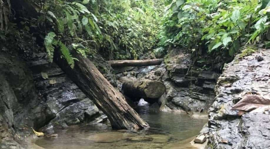
A lava tube once filled with red-hot magma flowing down a volcano dwarfs the cavers exploring it. The keyhole profile of this lava tube, on the volcanic island of Santa Cruz. suggests the floor of an upper tube may have collapsed into a lower tube from an earlier eruption. The “rope” handing down into the tube is actually a tree root. The islands have no fresh water, and the plants in the jungle canopy seek water everywhere — or just enough humidity to make it through the dry season. Credit: AARON ADDISON
(Phys.org) —Yearly expeditions to explore the lava tubes on the famed archipelago will culminate in an international symposium to be held there next year.
Whatever you did for spring break, WUSTL's Aaron Addison and Bob Osburn have you beat. They spent spring break mapping lava tubes—giant tubes through which red-hot rock once flowed—within a volcano on the island of Santa Cruz in the Galàpagos.
Despite the fame of the Galàpagos, many of its lava tubes, home to dark-adapted species unknown to science, have never been explored.
This year, during spring break, Addison, Osburn, and a team of nine cavers, were racing to map as many tubes as possible on Santa Cruz, which will be the venue for the 16th International Volcanospeleology Conference to be held March 15-22, 2014.
Totally tubular
Addison and Osburn saw their first Galàpagos lava tube during an Earth and Planetary Science field trip to the islands in the spring of 2006. Addison, Director of Geographical Information Systems & Data Services, and Osburn, a laboratory administrator for the Department of Earth and Planetary Sciences, both of whom are speleologists, made a little side trip to a lava tube called Cueva Gallardo, just to see what a lava tube looked like.
One look and they knew they would have to come back to the islands.
But getting permits to work in the Galàpagos, 97 percent of which is a conservation park, is notoriously difficult. Fortunately they made a well-connected friend on the same trip: Theofilos Toulkeridis, a faculty member at the Escuela Politécnica del Ejército who does geological research in Galàpagos.
With Toukeridis's help they were able to arrange trips in 2009, 2011 and this year.
The international conference will be hosted by Toulkeridis and co-chaired by Addison and Toulkeridis.

Osburn in a drained magma chamber on the southern flank of Sierra Negra, the largest volcano in the Galàpagos. On the island of Isabela, Sierra Negra last erupted in October 2005. Osburn says the startling colors are due to oxidation of the iron in the lava, most likely by gases streaming from the magma below. The color palette is bit wider than normal, he says, perhaps because conditions were more varied and harsher than usual. Credit: PETER SPROUSE
Into the magma chamber
The Galàpagos is a hotspot volcanic chain formed by a mantle plume, or upwelling of abnormally hot rock, in the Pacific Ocean near the Equator. As a tectonic plate drifts over the hot spot, magma ascending from below, melts, segregates from the rock and erupts to form a volcano.
A chain of volcanoes is formed as the crustal plate creeps over the hotspot. In a typical hot-spot volcanic chain, such as the Hawaiian islands, the islands at one end of the chain are older and dormant and those at the other end are younger and still active.

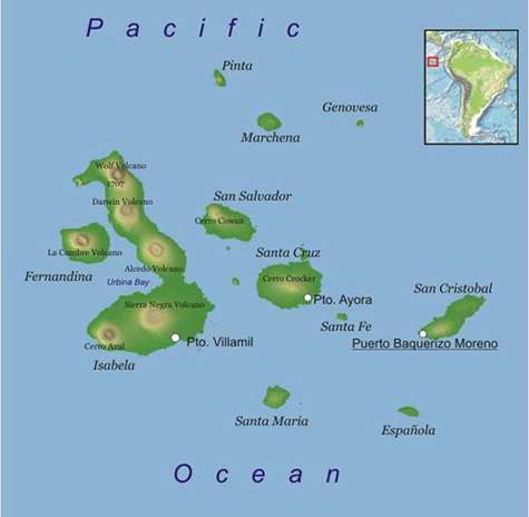
The WUSTL expeditions have been to the southern flank of Sierra Negra on Isabela and to Cerro Crocker on Santa Cruz. Most of the people in the Galàpagos live on Santa Cruz and San Cristobal islands. Access to all of the islands is carefully controlled, but especially to Fernandina both because it is an active volcano—it last erupted April 2009—and because it is the only island still without invasive species. Credit: Daniel Feher/ freeworldmaps.net, via WIKIMEDIA COMMONS
The theory doesn't quite work for the Galàpagos, however. The Galàpagos hot spot lies close to the Galàpagos spreading center, a mid-ocean ridge where the ocean crust is pulling apart, generating huge volumes of lava that is probably contaminating the hot-spot lava. The chemistry of the lavas suggests at least four reservoirs of magma are feeding the hot spot.
"Most volcanos do not produce lava tubes," Osburn says. 'To get a tube the lava has to be fluid (basaltic rather than rhyolitic) and fairly hot. The eruption has to be fairly voluminous so that the flow continues long enough to channelize and for the channel to roof over. Volcanos that erupt fluid basaltic lavas tend to form shield volcanos with flat profiles and gentle slopes, which also favor the formation of long-lasting lava tubes."
While the team was mapping the caves there was a torrential downpour unlike anything the locals had ever seen, and water came flooding into the tubes they were exploring.
"Lava tubes form because cooling lava is a fantastic insulator," Addison says. "As the lava begins to race down the slopes of the volcano, its outside cools much faster than the core, but because the cooled lava is such a good thermal insulator, the core remains superheated and can flow long distances, in some cases tens of kilometers."
Mapping the tubes
During this spring's expedition, Addison kept a blog of the team's adventures, called "Galàpagos Cave Exploration—2013"
that is full of astonishing images of the tubes (and a gorgeous photo of a fever of manta rays swimming off the pier at Puerto Ayora on Santa Cruz).
 Toulkeridis in a lava tube on Santa Cruz. The “benches”” or ridges at the sides of the tube form when lava flows at the same level for some time. On the ceiling is a blister, a pocket that somehow filled with air while the lava was cooling. Credit: AARON ADDISON")
Team members Rick Haley of the Cave Research Foundation, a nonprofit group dedicated to the exploration and conservation of caves, and (far ahead) Toulkeridis in a lava tube on Santa Cruz. The “benches”” or ridges at the sides of the tube form when lava flows at the same level for some time. On the ceiling is a blister, a pocket that somehow filled with air while the lava was cooling. Credit: AARON ADDISON
"Despite its romantic associations, the Galàpagos is a very hostile place to do research," Addison says. "The equator runs through the northern part of the archipelago, so it's very hot and the days are very long. In the highlands, it rains almost every day. It wears you down," he says.
They stayed in a hotel that cost $14 a night, with only a fan for cooling, and not even that during the three total-island blackouts when the diesel generators broke down.
They located tubes by talking to local ranch owners who were often able to lead them to openings to "tunnels" on their land. Once they found a tube, they took a GPS fix at its opening. Then, as they walked the tube, they charted the heading, elevation and distance between selected "stations," and used those measurements to draw plan and profile maps of the tube.

Addison’s field notebook. To the upper left are station numbers. From station 13 to 14, the distance was 15.87 meters, the heading was 210.5 degrees and the elevation was -2.5 degrees. These measurements were used to make the plan view of the tube. The small ovals to the side of the plan view are cross sections of the tube. The keyhole cross section and ladder to the upper right was formed when the upper tube collapsed into a lower one. The dotted circle beneath an ellipsoidal cross section downstream of that point indicates that here the two tubes run in parallel.
They'll be back to do it again for the international symposium – or sooner if they can organize the funds.
In the meantime we may all be able to participate as well, if only vicariously. In 2012 Addison made the trip to the Galàpagos as a consultant for Colossus Productions, a production company shooting an IMAX movie of the Galàpagos starring David Attenborough. The film, called Galàpagos 3D, has been screened in the United Kingdom but has yet to be released in the United States. It features appearance both by Aaron Addison and his fellow WUSTL-affiliated Galàpagos enthusiast, Stephen Blake, who studies the migration habits of the giant tortoise.
Regards


