
List members , here is an interesting perspective that reveals how flying in the far North is far from mundane , even for experienced pilots :-
Flying In The Far North: A Story Of Magnetism And Magic
By Sarah On Dec 16, 2021
0 13
One of my earliest experiences of the computer age — in college, in the early 1990s — involved repeatedly rereading (as one friend after another forwarded it to me) an article from Spy magazine that cast a doomful eye on the physics of Santa Claus’s Christmas errands.
Three decades later, whenever I set off on a flight across the far north during the festive season, I can’t help but recall that article’s portrayal of the likely fate of reindeer compelled to fly at Mach 3,000. But I’m reminded, as well, of what I didn’t know back then: that for airline pilots, routes across the Arctic have a magic all their own.
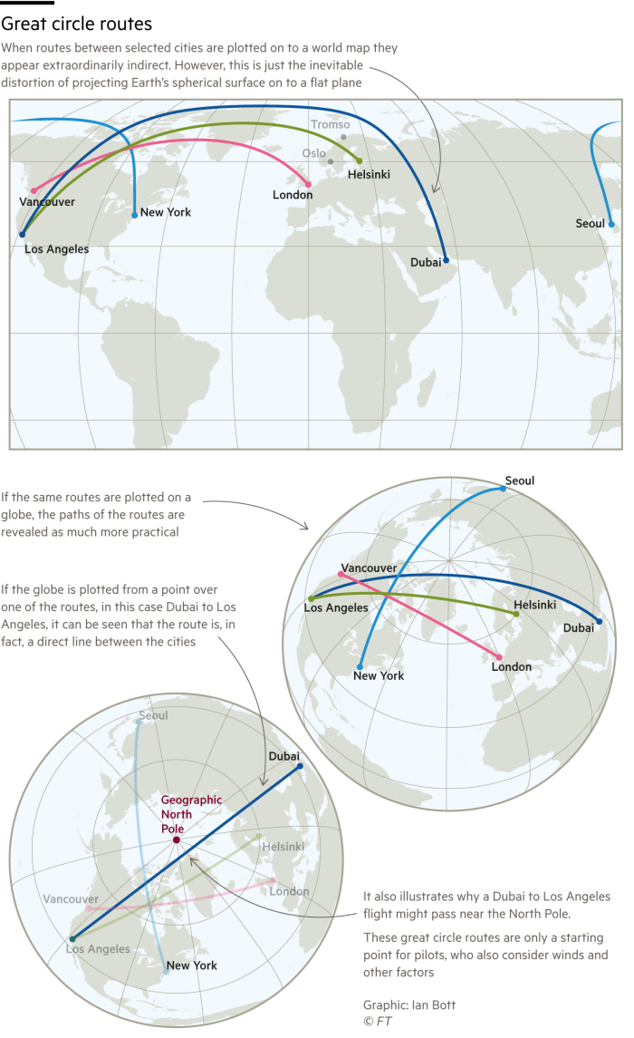
The starting point for every airline route planner is the “great circle” that connects two cities — in practical terms, the shortest path over the surface of the globe. On many great circle routes, an aircraft will reach a latitude greater than that of either its origin or its destination. A plane flying from Helsinki to Los Angeles, for example, will initially follow a northwesterly heading, despite Los Angeles being more than 1,800 miles further south than Helsinki. (A simple model — a string and an orange — demonstrates why.)
The flights on which I’m most likely to enter the Arctic are those between London and the west coast of North America. In summer, these routes offer views of some of the world’s most sparsely inhabited landscapes, and of natural phenomena such as the tree line, along which Earth’s great ring of northern forests at last gives way to tundra.
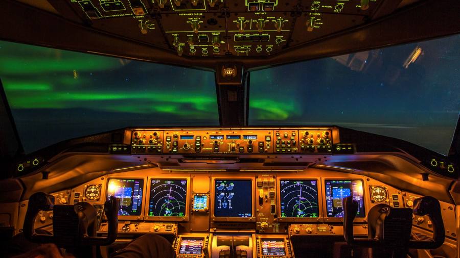
My most memorable ventures into the Arctic, however, are in winter and therefore in darkness. Vancouver to London is my favourite leg: after take-off around 9pm, we may head initially almost due north, on a route made memorable by the auroras that dance for hours between our dimmed cockpit and bright arrangements of unfamiliar stars.
In November, according to Ian Petchenik of flight-tracking website Flightradar24, an average of around 800 flights per day crossed the Arctic Circle. Some flights touch down within it: Oslo and Tromso constitute the busiest of the city pairings that straddle the Arctic Circle. Many other flights cross the Arctic without landing. JFK to Seoul was the most common such routing during Petchenik’s survey, while an aircraft travelling between Dubai and Los Angeles, two of the world’s most famously summery cities, passed within 60 miles of the North Pole.
One flight between Dubai and Los Angeles, two of the world’s most summery cities, passed within 60 miles of the North Pole
In some respects, flying in the Arctic is more straightforward than in other regions. In the far north’s uncrowded skies, our radios are mostly quiet, and we’re typically permitted to fly our most efficient routes, altitudes and speeds. Convective lift — that is, the fast-rising air that can generate precipitation and turbulence — is driven by the Sun’s warming of the Earth’s surface, and sunlight strikes the Arctic obliquely, when it strikes it at all. “Weather avoidance” is something I’ve never had to do in the Arctic.
One important consideration is the temperature of our fuel. At high altitudes the air temperature is typically around minus 57C — and it can be colder still in certain regions, as I first learnt when I flew the Boeing 747 on trans-Arctic routes from London to Tokyo. Minus 57 sounds bitter; however, the effective air temperature (what you’d feel if you stuck your hand out, and what pilots call “Total Air Temperature”) is much higher, because we’re moving so fast that the airflow warms the leading edges of our fuel-filled wings. If, nevertheless, the fuel starts to approach its freezing point, then a checklist (of course, there’s a checklist) requires us to descend to warmer air, or simply to accelerate: increasing our speed by 1 per cent of the speed of sound raises the TAT by up to 0.7 degrees.
Arctic flights also require pilots to consider various intricacies of navigation: most importantly magnetic variation — that is, the misalignment of the geographic and magnetic poles. In London, variation is conveniently around zero degrees, and in Rome about three degrees. At Iqaluit, in Canada’s Nunavut territory, variation is about 27 degrees, and at Thule, the Greenlandic airport whose name derives from Greco-Roman tales of the world’s northernmost place, it’s more than 40 degrees.

Another issue is inclination, or the angle that the magnetic field lines make with the Earth’s surface. At low latitudes, these lines can be as horizontal as telephone wires, and a floating compass needle aligns with them readily. At high latitudes — near to where the lines make their aurora-inducing vertical dives into the Earth — a compass, in the stern terminology of our Arctic charts, at first grows “unreliable” and then “unusable.”
Stretching south from the pole towards the Barents Sea is a slice of polar airspace that is curiously unclaimed and unnamed
Pilots account for these challenges in different ways. Perhaps the simplest way is to minimise our reliance on magnetic compasses. For this we depend on the brilliance of inertial reference systems, which provide us with magnetic headings that are derived, rather than sensed directly. These systems require several minutes of Zen-like perfect stillness at the gate before departure, during which they measure gravity and the direction of the Earth’s rotation — baselines from which, throughout our subsequent journey, they compute our true heading and other essential parameters. From our true heading, the aircraft’s position and a map of magnetic variation, our magnetic heading is determined. Indeed, in a modern cockpit there may be only one actual magnetic compass, mounted prominently in the centre of our forward-facing view.
In Arctic regions, where variation is both extreme and fast-altering, we swap — with a mere press of a button — these reliably derived magnetic headings for true ones. Even true headings, however, must be rapidly adjusted if we are to follow a great circle as we near the geographic pole. As a result, in the high Arctic, navigation is typically based not on headings but on paths between waypoints — such as NOPOL, which marks the North Pole.
One final fascination of polar navigation relates to the FIRs, or flight information regions (the countries of the sky, as I like to call them), into which the world’s airspace is divided. On flat charts, these regions appear to be nearly as box-like as a sequence of American states. In fact, at the North Pole, the world’s northernmost FIRs — Anchorage Arctic, Edmonton, Sankt-Peterburg and Nuuk — meet like slices of a pie.
I’m always entranced to see these far-flung place-names converge at one of the world’s ends, but more beguiling still is the slice that’s missing: a narrow arc of polar airspace labelled “No FIR.” Expanding southward from the pole towards the Barents Sea, it’s curiously unclaimed and unnamed, and it’s not hard to imagine how, on the most special night of the year, every Christmas-loving child could guess at the mystery it shelters.
Mark Vanhoenacker is a Boeing 787 pilot for British Airways and the author of ‘Skyfaring’ and the forthcoming ‘Imagine a City’ (Chatto & Windus/Knopf). Follow Mark on Twitter @markv747 or email him at [email protected]
Find out about our latest stories first — follow @ftweekend on Twitter
One of my earliest experiences of the computer age — in college, in the early 1990s — involved repeatedly rereading (as one friend after another forwarded it to me) an article from Spy magazine that cast a doomful eye on the physics of Santa Claus’s Christmas errands.
Three decades later, whenever I set off on a flight across the far north during the festive season, I can’t help but recall that article’s portrayal of the likely fate of reindeer compelled to fly at Mach 3,000. But I’m reminded, as well, of what I didn’t know back then: that for airline pilots, routes across the Arctic have a magic all their own.
The starting point for every airline route planner is the “great circle” that connects two cities — in practical terms, the shortest path over the surface of the globe. On many great circle routes, an aircraft will reach a latitude greater than that of either its origin or its destination. A plane flying from Helsinki to Los Angeles, for example, will initially follow a northwesterly heading, despite Los Angeles being more than 1,800 miles further south than Helsinki. (A simple model — a string and an orange — demonstrates why.)
The flights on which I’m most likely to enter the Arctic are those between London and the west coast of North America. In summer, these routes offer views of some of the world’s most sparsely inhabited landscapes, and of natural phenomena such as the tree line, along which Earth’s great ring of northern forests at last gives way to tundra.
My most memorable ventures into the Arctic, however, are in winter and therefore in darkness. Vancouver to London is my favourite leg: after take-off around 9pm, we may head initially almost due north, on a route made memorable by the auroras that dance for hours between our dimmed cockpit and bright arrangements of unfamiliar stars.
In November, according to Ian Petchenik of flight-tracking website Flightradar24, an average of around 800 flights per day crossed the Arctic Circle. Some flights touch down within it: Oslo and Tromso constitute the busiest of the city pairings that straddle the Arctic Circle. Many other flights cross the Arctic without landing. JFK to Seoul was the most common such routing during Petchenik’s survey, while an aircraft travelling between Dubai and Los Angeles, two of the world’s most famously summery cities, passed within 60 miles of the North Pole.
One flight between Dubai and Los Angeles, two of the world’s most summery cities, passed within 60 miles of the North Pole
In some respects, flying in the Arctic is more straightforward than in other regions. In the far north’s uncrowded skies, our radios are mostly quiet, and we’re typically permitted to fly our most efficient routes, altitudes and speeds. Convective lift — that is, the fast-rising air that can generate precipitation and turbulence — is driven by the Sun’s warming of the Earth’s surface, and sunlight strikes the Arctic obliquely, when it strikes it at all. “Weather avoidance” is something I’ve never had to do in the Arctic.
One important consideration is the temperature of our fuel. At high altitudes the air temperature is typically around minus 57C — and it can be colder still in certain regions, as I first learnt when I flew the Boeing 747 on trans-Arctic routes from London to Tokyo. Minus 57 sounds bitter; however, the effective air temperature (what you’d feel if you stuck your hand out, and what pilots call “Total Air Temperature”) is much higher, because we’re moving so fast that the airflow warms the leading edges of our fuel-filled wings. If, nevertheless, the fuel starts to approach its freezing point, then a checklist (of course, there’s a checklist) requires us to descend to warmer air, or simply to accelerate: increasing our speed by 1 per cent of the speed of sound raises the TAT by up to 0.7 degrees.
Arctic flights also require pilots to consider various intricacies of navigation: most importantly magnetic variation — that is, the misalignment of the geographic and magnetic poles. In London, variation is conveniently around zero degrees, and in Rome about three degrees. At Iqaluit, in Canada’s Nunavut territory, variation is about 27 degrees, and at Thule, the Greenlandic airport whose name derives from Greco-Roman tales of the world’s northernmost place, it’s more than 40 degrees.
Another issue is inclination, or the angle that the magnetic field lines make with the Earth’s surface. At low latitudes, these lines can be as horizontal as telephone wires, and a floating compass needle aligns with them readily. At high latitudes — near to where the lines make their aurora-inducing vertical dives into the Earth — a compass, in the stern terminology of our Arctic charts, at first grows “unreliable” and then “unusable.”
Stretching south from the pole towards the Barents Sea is a slice of polar airspace that is curiously unclaimed and unnamed
Pilots account for these challenges in different ways. Perhaps the simplest way is to minimise our reliance on magnetic compasses. For this we depend on the brilliance of inertial reference systems, which provide us with magnetic headings that are derived, rather than sensed directly. These systems require several minutes of Zen-like perfect stillness at the gate before departure, during which they measure gravity and the direction of the Earth’s rotation — baselines from which, throughout our subsequent journey, they compute our true heading and other essential parameters. From our true heading, the aircraft’s position and a map of magnetic variation, our magnetic heading is determined. Indeed, in a modern cockpit there may be only one actual magnetic compass, mounted prominently in the centre of our forward-facing view.
In Arctic regions, where variation is both extreme and fast-altering, we swap — with a mere press of a button — these reliably derived magnetic headings for true ones. Even true headings, however, must be rapidly adjusted if we are to follow a great circle as we near the geographic pole. As a result, in the high Arctic, navigation is typically based not on headings but on paths between waypoints — such as NOPOL, which marks the North Pole.
One final fascination of polar navigation relates to the FIRs, or flight information regions (the countries of the sky, as I like to call them), into which the world’s airspace is divided. On flat charts, these regions appear to be nearly as box-like as a sequence of American states. In fact, at the North Pole, the world’s northernmost FIRs — Anchorage Arctic, Edmonton, Sankt-Peterburg and Nuuk — meet like slices of a pie.
I’m always entranced to see these far-flung place-names converge at one of the world’s ends, but more beguiling still is the slice that’s missing: a narrow arc of polar airspace labelled “No FIR.” Expanding southward from the pole towards the Barents Sea, it’s curiously unclaimed and unnamed, and it’s not hard to imagine how, on the most special night of the year, every Christmas-loving child could guess at the mystery it shelters.
Mark Vanhoenacker is a Boeing 787 pilot for British Airways and the author of ‘Skyfaring’ and the forthcoming ‘Imagine a City’ (Chatto & Windus/Knopf). Follow Mark on Twitter @markv747 or email him at [email protected]
Regards